Microsoft Flight Simulator Handbook
by Jonathan M. Stern
Distance Measuring Equipment
The distance measuring equipment, or DME, can be used to display the slant range distance in nautical miles to a VORTAC or VOR-DME station. It also can be used to display the groundspeed in knots at which the aircraft is traveling directly to or directly from a VORTAC or VOR-DME station. If the aircraft is not traveling directly to or directly from the station, the speed readout is lower than the aircraft's groundspeed. The practical difference between a VOR, a VOR-DME, and a VORTAC is that the VOR does not provide DME capability.
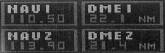
The DME operates in the ultra-high frequency (UHF) range and is automatically selected when the corresponding VORTAC or VOR-DME frequency is tuned with the NAV radio (see Figure 11.9). The DME frequencies, much like the glideslope with the localizer on the ILS system, are paired with the VOR frequencies.
The DME is far more complicated than the VOR in that it requires that the aircraft be equipped with both a transmitter and a receiver. The airborne equipment sends a signal out and receives a responsive signal from the ground-based equipment. The time it takes from sending the signal to receiving the reply determines the distance of the aircraft from the station. The airborne equipment makes the calculation of distance by multiplying rate of speed of radio waves (186,000 miles per second) times elapsed time and then dividing by two to reflect that the measurement was of a round trip.
The distance readout is a slant range—in other words, the distance from the station to the aircraft, not the distance over the ground along the same path. When an aircraft passes over a VORTAC at 35,000 feet, the DME distance readout is approximately 5.8 miles. By its geometry, the difference between slant range and distance over the ground is greatest when the aircraft is close to the transmitter.
To test this, follow these steps:
- Select the Lear 35 while at Chicago's Meigs Field.
- Pause the simulation and use the World/Set Exact Location menu to place the aircraft at 35,000 feet. The DME from Chicago O'Hare should read approximately 16.5.
- Now, return the airplane to the ground by selecting an altitude of 0 in the World/Set Exact Location menu. Note that the DME now reads 15.5.
- Unpause and rotate the OBS (omni-bearing selector) until the CDI centers with the TO/FROM indicator reading TO.
- Now, take off and select NAV Hold on the Nav/Autopilot menu to track directly to Chicago O'Hare. Set the Altitude Hold on the autopilot to 35,000 feet.
- Use the World/Set Exact Location menu to place the airplane back at 35,000 feet. When the Lear passes over the VORTAC antenna, the DME should read 5.8 miles.
Table of Contents
Previous Section: Automatic Direction Finder
Next Section: Marker Beacon Receiver