Microsoft Flight Simulator Handbook
by Jonathan M. Stern
Navigator
Navigator is a Windows-based flight planning package designed for use with Flight Simulator. Figure 15.9 shows the opening screen.
The original version of Navigator was written by Georges Lorsche, the same person who brought us Final Approach. Navigator was rewritten by Georges Lorsche and Ralf Wiegandt of Germany.
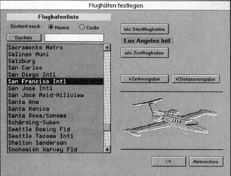
Navigator, which has a very slick look and feel, is useful for planning IFR or VFR flights for Flight Simulator. You can generate automatic flight plans simply by specifying departure and destination airports (see Figure 15.10).
Navigator randomly generates weather, which you then can accept or manually override. The program comes with data on the Cessna 182RG, Lear 35, and five other aircraft, including several Boeing and Airbus airliners. Data for other aircraft can be added by the user.
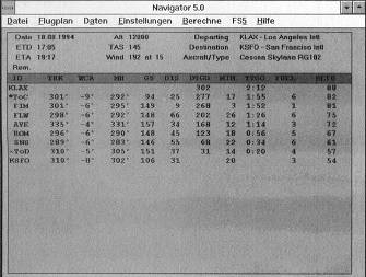
Navigator prints a comprehensive flight log, which includes each fix, the course, wind correction angles, magnetic headings, groundspeed, leg distance, distance remaining, time enroute, time remaining, fuel burned, fuel remaining, and information about the departure and destination airports. In each flight log, a top of climb and top of descent waypoint is generated automatically. The top of descent is the point at which a descent at a normal rate should be initiated. A selection of appropriate alternate airports is offered by the program.
With two clicks of the mouse, the route is displayed graphically. When the trip is so long that it cannot be displayed on a single screen, Navigator divides the route into segments, sequentially displaying each segment. Navigator's flight logs and graphics can be sent to your printer so that they are available during the planned flight.
Navigator includes all of Flight Simulator's standard airports and VORs and an unlimited number of each can be added by the user. Flight planning may be done manually or automatically.
The calculation of a flight from the East coast of the United States to the West coast takes less than 10 seconds to complete on a computer using a 486/50 processor. The number of aircraft is unlimited and for each aircraft 16 individual parameters may be specified.
Navigator programs Flight Simulator with the planned flight, if desired. In other words, it programs the specified weather parameters, season, and time of day, and places the aircraft at the appropriate departure point with the radios preset to the local ATIS and first VOR in the planned route. Moreover, Navigator includes a nifty utility that converts fuel volumes to weights, nautical miles to kilometers, Fahrenheit to Centigrade, letters to Morse Code, indicated airspeed to true airspeed, and true airspeed to Mach number.
It also calculates wind correction angles and descent rates necessary to descend a stated number of feet in a stated number of miles.
Navigator 5.1 is now available in English (among other languages). For more information in North America, call or write:
Vision Distribution INC
3787, Cote des Neiges #501
Montreal - Quebec
H3H 1V9 Canada
Phone: (514)931-4778
Fax: (514)931-4923
In Europe, call or write:
Colorado Technologies
155, rue de Rosny
Cap St. Antoine
F-93100 Montreuil sous Bois
Phone: (1)4859 2850
Fax: (1)4859 2812
Although it is also an extremely capable flight planner for flights in the United States, Navigator was used in this book for your flights in France and Germany.
Table of Contents
Previous Section: RMS Technologys Flitesoft Pro
Next Section: Flight Planner 5