Microsoft Flight Simulator Handbook
by Jonathan M. Stern
Chateaudun to Paris
Much has been written and discussed in the United States about the $100 hamburger. That's where the hamburgers at the distant airport restaurant cost $4 and the rental of the airplane to get to and fro costs $96. Perhaps, with the gastronomical experiences awaiting you in Paris, a city with 10,000 restaurants and cafes, the $100 hamburger (or salmon in hollandaise sauce) is entirely justifiable. Of course, the $100 hamburger was the result when the trip was made in the Cessna. With the flight in the Lear, you're more likely looking at the $1,000 hamburger.
You will start the flight at a small airport approximately 100 miles Southwest of Paris, at the town of Chateaudun:
- Use the World/Set Exact Location menu to place the airplane at latitude N 048° 03' 41.3377" and longitude E 001° 21' 47.0747".
- Set the altitude to 436 feet and the heading to 107°.
- Use the Options/Aircraft menu to climb aboard the Lear 35, and program the weather for a 590 foot cloud base with 7/8 broken coverage.
- Because Paris is known as The City of Light, make this a night flight by setting the clock to 2200 hours.
- Figures 17.20 and 17.21 contain the Navigator 5.0-generated flight log and graphical printout. Study the flight log and route printout.
Figure 17.20. This flight log for the trip from Chateaudun to Paris was prepared by Navigator 5.0.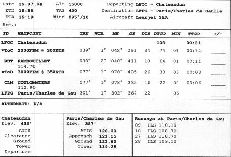
Figure 17.21. The graphical route printout for the trip to Paris.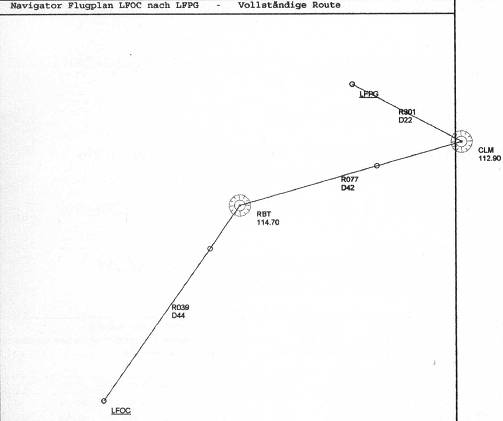
- Prepare the cockpit for departure by setting up the instruments and radios. Tune the NAV 1 to Rambouillet VORTAC on 114.7 and the NAV 2 to Coulommiers on 112.9. Squawk 1-4-1-1 for the trip.
- Set the flaps to eight degrees for takeoff and make a normal takeoff. Make a left turn to join the 219° radial Northeastbound while climbing to 15,000 feet. The small circle just Southwest of the RBT VOR marks the ToC, or top of climb. This is the point at which Navigator computes the Lear will reach cruising altitude, in this case 15,000 feet. Likewise, the small circle between RBT and CLM is the ToD, or top of descent. This is the point at which Navigator computes that you must begin your descent.
Although the ToC and ToD points are likely not precise, they provide valuable flight planning information. The ToD point is especially helpful in that it acts as a reminder that a descent should be initiated prior to reaching the initial approach fix. This is particularly true with the Lear and other aircraft that cruise at high altitudes. By using the 2,000 FPM climb rate calculated by Navigator, I found that I reached the top of climb checkpoint right around the time that I leveled the Lear at 15,000 feet.
- Continue tracking to RBT. At RBT, turn right and track outbound on the 77° radial. The changeover point is the midpoint; switch navigation to Coulommiers at 21 miles from Rambouillet. When the Lear is 16 miles out from Coulommiers, you've reached the top of descent point. Begin a descent to 7,000 feet. See Figure 17.22.
- When you arrive at CLM, pause the simulation and save the situation as City of Light. Then, exit Flight Simulator or reset the simulation to the Meigs Takeoff Runway 36 situation.
Table of Contents
Previous Section: Champaign to Chicago
Next Section: Innsbruck to Munich