Runway USA
A pilot's guide to destination cities in Flight Simulator
by Charles Gulick
Git Along
The city of Liberal, Kansas, is a good place to have pancakes for breakfast. The housewives here are experts—not just at mixing the batter but at flipping the cakes. On Shrove Tuesday (the Tuesday before Ash Wednesday) of every year, they compete with their counterparts in Olney, England, in the International Pancake Race. They run a quarter of a mile with skillet in hand, and pancake in skillet, flipping the pancake twice en route. If you think that's easy, just try it.
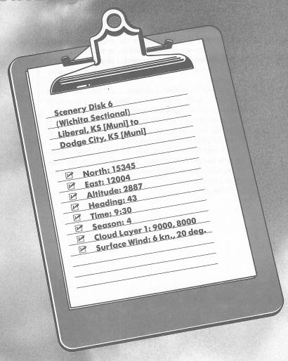
We're en route for storied Dodge City, so let's get rolling. Runway 3 here at Liberal Municipal Airport practically points to our destination.
Take off and fly straight, leveling off at a cruise altitude of 5500 feet. Remember my lyric poem:
When fly you would a heading west,
Odds are you'll evens find are best,
Plus 500.
(40 More Great Flight Simulator Adventures)
With those words engraved on your memory, you'll never be confused as to what altitudes to fly to satisfy FAA regulations. Since we're flying east this morning, you just turn the meaning of the poem around and select an altitude of odd thousands plus 500 feet—that is, 3500, 5500, 7500, and so forth. Going west, you'd select 4500, 6500, or 8500. This isn't always strictly adhered to, but it keeps the FAA happy. Below 3000 feet you can choose any safe altitude that happens to suit you.
Liberal's population is about 15,000—big enough to make it into the simulation. You can see the city off to your right and behind you as you climb.
As you approach your cruise altitude, tune Dodge City VOR on 108.2 and fly the 38-degree radial inbound.
The water you see just below the horizon is the Arkansas River. Here in Kansas, it's called the Ar-KANSAS River. And of course you can guess how it's pronounced in Arkansas. Dodge City lies alongside the river, where U.S. 56—now on your left—and U.S. 50 merge.
About a hundred years ago, Dodge City was a railhead to which herds of longhorns were driven, and a wide-open cattle town where cowpokes went to whoop it up on payday. It took lawmen of the likes of Luke Short, Wyatt Earp, and Bat Masterson to keep the peace in Dodge City, and to fill Fort Dodge jail, as well as the famous Boot Hill cemetery, with the incorrigibles.
The highway on your right is U.S. 54, which goes to Meade, Kansas, where the Dalton Gang used to hide out (there's a museum there now in their honor, complete with a tunnel they used to escape the law), and on east to Wichita.
About 35.5 nautical miles out you'll be able to see Dodge City on radar, and after another mile or so U.S. 50 will streak across the horizon, on the other side of the Arkansas River. That will be followed in a matter of seconds by the appearance of the Dodge City metropolitan area, where Highways 56 and 50 meet.
Dodge City Municipal Airport is east of the city, and your course puts you in a good position for a straight-in approach to the active Runway 2. If you fly a heading of about 60 degrees for a while, to the right of and paralleling U.S. 56, you can then make a left turn and get lined up a good distance out. Start planning this as soon as you can identify the airport, which is on the north side of the river. You might want to turn right, heading 110 degrees, which will put you on a course paralleling the base leg. Then, when Runway 2 appears nearly straight when you take a 90-degree view out the left side, turn to your long final and start your letdown.
As you get closer in, you'll have a better idea of the lie of the runway. When your DME reads about 9 NM, you'll be able to see Runway 2 on radar. The field elevation is 2594 feet. This long approach over the river, while not one of the scenic wonders of the simulator, is a pleasant and realistic one. Take a look at Dodge City out the left side as you descend.
Table of Contents | Previous Chapter | Next Chapter