Microsoft Flight Simulator Handbook
by Jonathan M. Stern
Route Selection
Before selecting the route, it is wise to get an outlook briefing from the Flight Service Station (FSS). An outlook briefing provides an overview of the weather between the destination and departure airports without getting into too much detail at this preliminary stage. Depending on what you find, you may decide that the trip cannot safely be flown, that the most direct route is too hazardous, or, most likely, that the trip can be made in a reasonably direct manner. Given the safety with which you fly your Flight Simulator trips, you need not be as concerned about this step as you would be if you were planning on flying this trip in a real aircraft.
When you select your route, keep in mind your own limitations and those of the airplane. For example, you may find that the normally aspirated engine on your Cessna 182RG may not get you over the Rockies on the most direct route available. Oxygen requirements in the FARs (which mandate the use of supplemental oxygen at altitudes as low as 12,500 feet MSL) are another limiting factor, as may be the size of your bladder for long trips. Icing is another concern in your 182, and you generally will not want to fly for prolonged periods above the freezing level in the clouds unless the temperature is significantly below freezing.
In selecting your route of flight, you must consider these items, as well as the minimum enroute altitudes along the available routes of flight and the availability of standard instrument departures (SIDs) and standard terminal arrival routes (STARs). Pilots who are not in possession of SIDs and STARs are expected to indicate "NO SIDS/NO STARS" in the remarks section of their flight plans so that ATC knows they need to have the requirements of SIDs and STARs read to them. Moreover, before the trip is actually flown, NOTAMs, or Notices To Airmen, must be checked for NAVAID outages, airport or runway closures, and other pertinent information.
The route of flight is selected from an enroute chart. Figure 15.2 is an excerpt of the L-25 chart, which contains the route of flight for a trip between Boston, Massachusetts, and Windsor Locks, Connecticut.
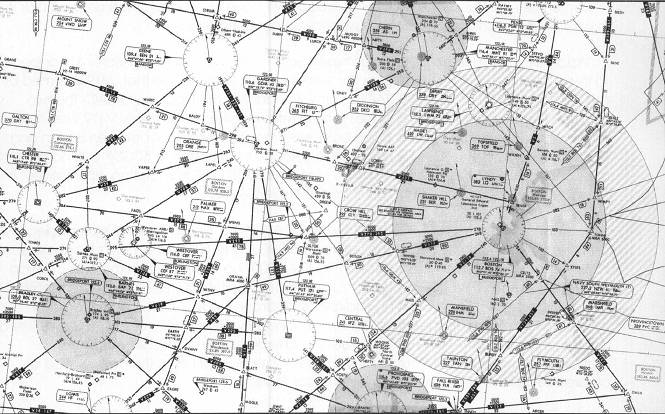
Remember that all of the charts in this book will have expired by the time the book is in print, and the charts must not be used for actual navigation.
Victor 419 is the most direct route between Boston and Windsor Locks. Victor 419 appears to the West of the Boston VORTAC on the enroute chart. You can see that V419 is formed by the 268° radial of the Boston VORTAC and the 86° radial of the Bradley VORTAC. The two degree difference results from changes in magnetic variation. If you follow V419 West from Boston, you will see a 30 in a D-shaped box below the route segment between Boston and BOSOX intersection. This 30 indicates that the distance from Boston to BOSOX is 30 nautical miles and that BOSOX intersection can be identified by 30 DME from Boston. Alternatively, it could be identified by the 151° radial from Gardner VORTAC.
You can see the MEA (3,000) and the MOCA (2,500), which is always preceded by an asterisk (*). The route segment between BOSOX and GRAYM is 19 nautical miles. Notice that under GRAYM intersection is MRA 4000. An MRA is a Minimum Reception Altitude. It means that the airplane may have to be at 4,000 feet in order to identify GRAYM intersection as a crossing radial from Gardner VORTAC. It is not necessary, however, to be able to identify the intersection to fly along V419 unless ATC requires a position report at GRAYM. You also need to check for the availability of STARs, Standard Terminal Arrival Routes, at your destination. STARs simplify the issuance of clearances. There are no STARs, however, for Bradley.
For the flight log, note the various fixes along the route of flight (Boston, BOSOX, GRAYM, WITNY, and Bradley). These are entered on the log. You also note the magnetic course of 268 and 266 (the reciprocal of 86). Finally, with respect to the LAE chart, distances between each fix should be recorded on the flight log.
Table of Contents
Previous Section: The Old Fashioned Way
Next Section: Weather Briefing