IFR Flights of 13MIKE
by Fred J. Calfior and Douglas W. Miller
| Flight Scenario Six |

Oceanside to Van Nuys |
(Southern California Area - estimated flying time 65 minutes)
Here we are back in Southern California! I was looking forward to lying on the beach and catching some rays, but it looks overcast and rather crudy! So I guess we can go flying. It's a great day for practicing your instrument flying inside a very busy airspace like Los Angeles' class B. Even though you are IMC (I can't see a thing!), you still need to stay alert for other aircraft and cumulus granite (mountains). It is totally beyond me, but some pilots will fly into places where they have no business flying, like clouds - and no one knows that they are there until it's too late. So stay alert.
This flight looks exciting. You'll leave Oceanside Airport, that's north of San Diego and south of Los Angeles, and transition through the Los Angeles busy class B airspace to shoot the ILS approach into Van Nuys. Let's look over the flight plan so you and Professor Calfior can get your weather brief. You and I will then setup some real derelict weather that you and Professor Calfior can practice in. Professor Calfior will love, just love, this flight! He will probably talk the entire flight!
Stay alert and listen to Professor Calfior. His wisdom could save your life someday.
FLIGHT PLAN -
This route of flight follows well established departure, climb, cruise, descent, and landing procedures. At 0430 Zulu, you will depart Oceanside Municipal (Airport diagram and Departure procedures in Appendix C6) on runway 6. You are going to follow its IFR departure procedure which is a climbing right turn to a heading of 235 until reaching 1500 feet. You will initiate contact with San Diego Departure Control. Once past 1500 feet, then you need to turn further right and go direct to Oceanside VOR. True airspeed at your cruise altitude of 6000 feet is 140 knots.
Look at the low altitude enroute chart L-3 in Appendix B2. Upon reaching station passage at Oceanside VOR, you will proceed outbound on Victor 23, which is the 300 radial. Los Angeles Center will be controlling you at this point. At the halfway point between Oceanside VOR and Seal Beach VOR, you will transition to the Seal Beach VOR 120 radial inbound. Since you have a clearance only to Seal Beach VOR at this time, you will have to hold at Seal Beach until further clearance is received.
The holding pattern at Seal Beach is left hand turns off of the airway, so you can enter it direct. Once your further clearance is received, continue on Victor 23 off of the Seal Beach VOR 272 radial to HERMO intersection, which is 16 DME. Then fly on the Los Angeles VOR 124 radial inbound.
Once you have station passage at Los Angeles VOR, head direct to Van Nuys VOR. Los Angeles Center will hand you off to Burbank Approach Control who will probably clear you for the ILS RWY 16R approach (Appendix C6). Van Nuys VOR is the initial approach fix for this approach, and you proceed outbound on the 324 radial, maintaining 6000 feet.
Almost 15 miles out, you'll turn right on the Fillmore VOR 054 radial for 4.3 miles, so that you will intercept the Van Nuys localizer 340 radial inbound. Once you pass UMBER intersection, you can descend to the minimum glideslope altitude of 4300 feet, where you will then intercept the glideslope. Decision height for straight in to runway 16R is 1040 feet, which with the field in sight, you will land. Van Nuys airport diagram is in Appendix C6. If the field is not in sight at decision height, you will execute the published missed approach procedure and proceed to Oxnard Airport. Your 5 hours and 50 minutes of fuel on board is plentiful enough for this 65 minute trip.
FILLING OUT THE FLIGHT PLAN -
Fill out the following Fight Plan completely, carefully paying attention to your route of flight. Trace out your route using the IFR low altitude enroute chart L-3 given to you in Appendix B2.
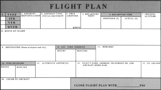
Now answer these questions from your flight plan and enroute chart.
** a) What is in block 8, Route of flight, of your flight plan?
_____________________________________________(10 pts)
** b) There are four intersections along Victor 23 from Oceanside VOR. What are they and who are they referenced from?
1.____________________________________________
2.____________________________________________
3.____________________________________________
4.____________________________________________
Referenced from_________________________________(10 pts)
** c) What kind of a navigational aid does John Wayne-Orange County Airport have that's shown on the enroute chart?
________________________________________________(10 pts)
** d) The airfield east of Van Nuys Airport is named what?
________________________________________________(10 pts)
** e) Los Angeles International Airport can accept special VFR traffic.
True or False________________________________________(10 pts)
"Something a pilot should do often is to give pilot reports on current weather. Those become so invaluable to any pilot about to fly, and they are so easy to make. There is a format to giving these PIREPS, but don't let that deter you from giving them. When all is said and done, it's what you're saying or reporting that's newsworthy, not how you say it. But so you have an understanding of a complete PIREP, here are its parts:
1) Some 3 letter station identifier nearest you
2) Whether the PIREP is routine or urgent
3) Your location in relationship to a VOR
4) Time
5) Altitude
6) Your aircraft type
7) Sky cover - in other words, cloud coverage and height
8) The kind of weather you're encountering
9) Temperature
10) Wind
11) Turbulence
12) Icing
And any other remarks which you feel are important. On some future flights which we'11 fly together, we'11 work on giving some PIREPS. But I want you to see that they are fairly easy to give and to understand.
Well, it's time for another brief. You'11 have to call San Diego this time, since Oceanside obviously doesn't have its own FSS! See you in about fifteen, twenty minutes, Okay?"
Table of Contents
Previous Section: Flight Scenario Five: Flight
Next Section: Flight Scenario Six: Weather Brief