IFR Flights of 13MIKE
by Fred J. Calfior and Douglas W. Miller
| Flight Scenario Eight |

Block Island to Marthas Vineyard |
(New York Area - estimated flying time 45 minutes)
It looks like Professor Calfior found Watsonville after all. I gave him directions that Wrong Way Corrigan could have followed! It seems just a short time ago we were on scenario one and here it is scenario eight. They have been exciting flights and I hate to see this all come to an end. But wait! I have a great idea! I'll talk Professor Calfior into helping me write another book, and we can continue our adventures with 13MIKE. I think we'll call it Airienteering with "13MIKE". What is Airienteering, you say? Well, Airienteering is the art of pilotage by way of clues. These clues come in the form of puzzles of various sorts, brain teasers, consulting your local aviation books, or fellow flyers. Most of, but not all, the answers to the puzzles will be provided. I get excited just talking about it! Before we forget, you have a flight to go on. So let's get cracking! You depart Block Island, Rhode Island and shoot the ILS into Marthas Vineyard, Massachusetts. The ceilings are going to be rather low, so be ready for anything. You will go over the flight plan, get the weather, file your flight plan, setup the aircraft, pick up Professor Calfior and have an exciting flight.
See you in the next book. Professor Miller signing off.
FLIGHT PLAN -
This route of flight follows well established departure, climb, cruise, descent, and landing procedures. It is a nice short 45 minute flight, and you have lots of fuel on board. You have computed 6 hours. You will depart Block Island State Airport (Airport diagram in Appendix C8) at 2345 Zulu on runway 28. Upon takeoff, maintain runway heading until 1500 feet, then reverse your course with a turn to the left and go direct to Block Island NDB. Climb up to 5000 feet as cruise altitude. Your true airspeed at cruise will be 120 knots.
You will contact Ocean Departure as soon as possible so they know you're airborne. Now follow the IFR low altitude enroute chart L-25 in Appendix B6. At station passage over Block Island NDB, you will proceed outbound on Victor 268 which is the Sandy Point VOR 046 radial to MINNK intersection. If Sandy Point VOR continues to be out of service, then you can expect radar vectors and a flip over to Boston Center.
Eventually, you'll intercept Victor 374, which is flown via the Marthas Vineyard 282 radial inbound. You might want to descend to 3000 feet on Victor 374 since that is its minimum enroute altitude. As you near Marthas Vineyard, you will be switched to Cape Approach Control, where you will be cleared for the ILS RWY 24 instrument approach procedure into Marthas Vineyard. From 3000 feet, you'd descend when cleared, to 1500 feet.
The ILS RWY 24 instrument approach plate (Appendix C8) shows that BORST intersection is the initial approach fix. So from Marthas Vineyard VOR, you'd turn left to track outbound on the Marthas Vineyard 058 radial for 4.2 miles until intercepting BORST intersection at 5.0 DME on the Marthas Vineyard localizer.
Now, you need to reverse course so that you can proceed inbound on the final approach course. To do that, it's a holding pattern turn as depicted, so you must shoot for the outside corner of the holding pattern shown. That takes a 30 degree cut, called a teardrop entry, to a heading of 086 for 1 minute, then a standard rate turn to the left in order to intercept the Marthas Vineyard localizer for a 236 degree inbound course.
When glideslope is intercepted, descend on glideslope to your decision height of 263 feet for a straight in landing to runway 24. Again, the cloud deck is fairly low, so be prepared to execute missed approach procedures to New Bedford Regional, if the field is not in sight. Marthas Vineyard airport diagram is in Appendix C8.
FILLING OUT THE FLIGHT PLAN -
Fill out the following Flight Plan completely, carefully paying attention to your route of flight. Trace out your route using the IFR low altitude enroute chart L-25.
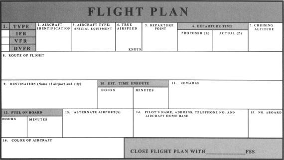
Now answer these questions from your flight plan and enroute chart.
** a) What is in block 8, Route of Flight, of your flight plan?
___________________________________________(10 pts)
** b) With a runway 28 departure from Block Island, and a left turn back to the NDB, what navaid, radial and DME would be most appropriate to also help define the NDB as a backup?
___________________________________________(10 pts)
** c) What is the airport elevation at Marthas Vineyard Airport?
___________________________________________(10 pts)
** d) What is the TACAN (Tactical Air Navigation used by the military) station frequency at Marthas Vineyard?__________________(10 pts)
** e) MLNNK intersection is what DME:
from Norwich VOR___________________________________
from Marthas Vineyard VOR____________________________
from Sandy Point VOR________________________________
from Groton VOR____________________________________(10 pts)
"Another beautiful evening in the Caribbean with floating banana boats, and a Bartles and Jaymes Pina Colada wine cooler to ease our blanched and pallid brows from the balmy sweat induced eighty plus degrees of muggy temperature! It's my fantasy, so shut up … please! Reggae music is playing in the background, and I can just hear the giggling laughter of children playing on the beach. All of a sudden, in a whirlwind, a NOTAR helicopter signals to land on our verandah, and one of those fancy hotel doormen steps down, snaps me a salute, hands me a message in a bottle, gets back in the cockpit, and disappears into the evening twilight!
Pretty dumb to send a message in a bottle, because most of the time, one has to break the dumb bottle to get it! I do! It's addressed to me in a painful script, an urgent appeal, call it a plea if you want, to put an end to the second book in the series of CalMil's flying adventures! There are tear stains on the cracked paper, no doubt due to the personage's sadness over the book again coming to an end.
Well, fear not, oh troubled heart! For there is much more to the instrument environment than one book can detail. We shall return with a following more advanced set of flight scenarios for the fourth book in the series! With a wave of my hand, an SR-71 Blackbird Stealth aircraft lands on my verandah, and at Mach some secret number, I gladly dedicate myself to Block Island, Rhode Island, to fly this last scenario with a very astute, well deserving, and emotionally relieved instrument pilot!
Weather brief, if you will.
It'll take a call in to Bridgeport, since Block Island is kind of a floating paradise of isolation in the Atlantic."
Table of Contents
Previous Section: Flight Scenario Seven: Flight
Next Section: Flight Scenario Eight: Weather Brief