Cross Country
by Alfred Poor
Caribbean
Flight 3
Flight to Visit the King
Off the eastern tip of Puerto Rico lie the chain of emerald jewels known as the Virgin Islands. The first in the chain is Saint Thomas—one of the United States islands—which is served by Cyril E. King Airport.
For this flight, you’ll travel along the rugged and beautiful southern coast of Puerto Rico, cross the Pasaje to Vieques and the Virgin Passage, and find your island in the sun.
Planning a Route
Your point of departure will be Ponce Airport, in the middle of Puerto Rico’s southern coast. You can then use pilotage to follow the coastline around to the east.
|
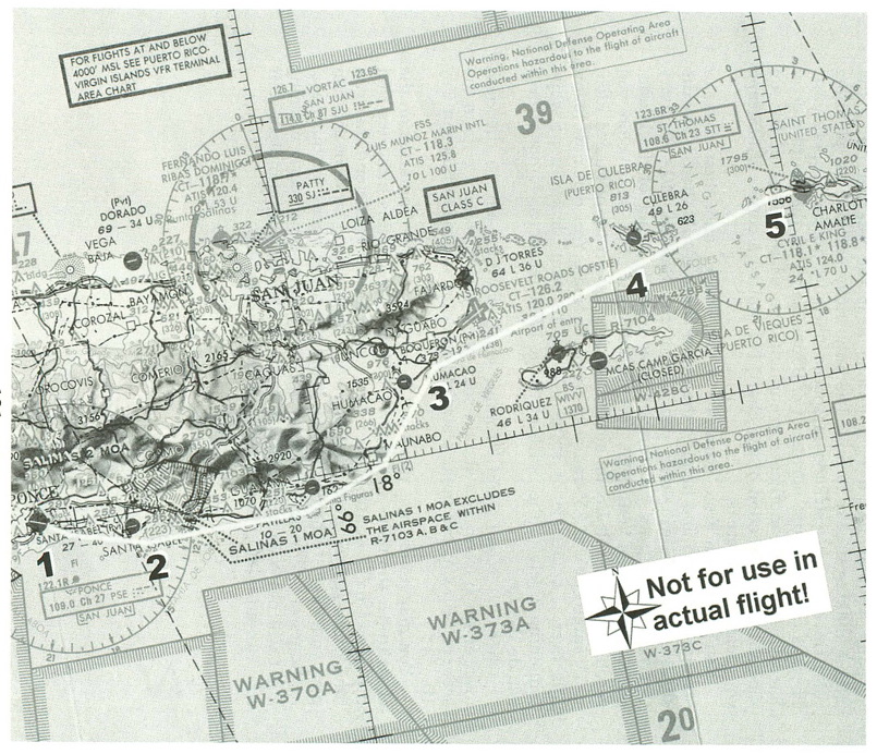
Saint Thomas has a VOR located near the western tip of the island, making it easy to find. The only tricky parts about planning this trip are the restricted airspaces used for military operations. There is one area just northeast of Santa Isabel on the south side of Puerto Rico, and another surrounding the eastern half of Isla de Vieques. On the section of the chart, I’ve plotted a course that keeps you clear of both areas.
You’ll take off from Runway 30 at Ponce, and then make a standard left turn and head to the south shore. You’ll then follow the shoreline (which will keep you out of the Salinas MOA (Military Operations Area). As you round the southeast corner of the island, the Saint Thomas VOR (STT, 108.60) will come alive. Just before you reach the Roosevelt Roads airfield on the eastern tip of Puerto Rico, you’ll intercept the 85º radial to Saint Thomas. You can now follow this over a sequence of small islands to your destination, while remaining safely to the north of the R-1704 restricted airspace over Isla de Vieques.
Once you reach Saint Thomas, you’ll want to aim to the right towards the harbor. You should soon see the airport emerge from the scenery, and you can make a straight-in approach to land on Runway 10.
You may notice that there is a “CT-118.1* 118.8*” notation on the chart under the name of the Cyril E. King airport; this indicates that the airport has a control tower. Now, you can either pretend that you have contacted the tower and received permission to land, or you can plan your flight to be completed before the tower opens for business. Its hours of operation are 7:00 am to 10:30 pm, so an early morning flight will not only be beautiful, but will also let you complete your trip without talking to any Air Traffic Control facility.
|
How High to Fly?
As with the other Caribbean flights, this trip involves a fair amount of over-water travel. The difference for this trip, however, is that you will never be out of sight of land. There is even a convenient emergency landing site halfway to your destination: Culebra Airport.
As a result, you don’t need to gain as much altitude as you have in other flights. According to the VFR guidelines of odd thousands plus 500 feet for headings in the eastern half of the compass rose, you could choose 3,500, 5,500, or 7,500. I picked 5,500 because this will give you a good view without having to climb too far up, and you will be able to keep the land in sight along your route.
As a result, you’ll need to continue your takeoff climb for about 13 minutes (assuming a standard 500 fpm cruise climb rate) before leveling off for a 130 knot level cruise speed. At the other end, you will need to lose nearly 5,000 feet to get to pattern altitude, which will take about 10 minutes at 500 fpm, which uses up about 22 miles at 130 knots. This works out to starting your descent just before you get to Isla de Culebra.
Getting Ready to Fly
It is easy to set up this flight. You can choose “Ponce - Mercedita” from the CBN-Puerto Rico list in the World Airports menu. This will place you on Runway 30, ready for takeoff.
Next, tune your NAV1 radio to 108.60 for the Saint Thomas VOR; you won’t be able to verify this setting until the signal comes alive later in your flight. Set the OBS to the 85º radial.
If you want to get in ahead of the control tower, you’ll have to take off before dawn. Choose the World Set Time and Weather command, and set the exact time to 5:50 am. This will make it tight getting in before the 7:00 am deadline, but if you fly efficiently, you can make it. This also means that you must start your trip in the dark, but you can follow the lights of the roads along the coast; keep them to your left, and you can follow the coastline until the sky gets lighter.
< Situation file: XC-CA3
Table of Contents
Previous Section: From Paradise to the Stars — Paradise to Stella Maris
Next Section: Section E: Japan