Microsoft Flight Simulator Handbook
by Jonathan M. Stern
Landing Minima
The landing minima section of the chart contains visibility and altitude minima for the approach. The minima vary by aircraft category, determined by the aircraft's approach speed, using 1.3 VSO as approach speed. Table 14.1 shows the approach categories and their corresponding speed ranges. Although the legal requirements are predicated on the 1.3 VSO figure, good judgment suggests that the minima corresponding with a higher category be utilized if the speed actually used for the approach falls in a higher category.
| TABLE 14.1 Approach Categories and Speed Ranges | |
| Category | Speed |
| A | 0-90 knots |
| B | 91-120 knots |
| C | 121-140 knots |
| D | 141-165 knots |
| E | 165 knots and faster |
The approach may not be continued beyond the missed approach point unless the flight visibility is equal to or better than the requisite visibility listed in the landing minima section, the pilot is able to see at least one of the visual references associated with the landing runway (listed in Table 14.2), and the aircraft is in a position from which a normal landing can be achieved using normal maneuvers and a normal rate of descent.
| TABLE 14.2 Visual References on Landing Runways | |
| Reference | Meaning |
| i | The approach light system, except that the pilot may not descend below 100 feet above the touchdown zone elevation using the approach lights as a reference unless the red terminating bars or the red side row bars are also distinctly visible and identifiable |
| ii | The threshold |
| iii | The threshold markings |
| iv | The threshold lights |
| v | The runway end identifier lights |
| vi | The visual approach slope indicator |
| vii | The touchdown zone or touchdown zone markings |
| viii | The touchdown zone lights |
| ix | The runway or runway markings |
| x | The runway lights |
The visibilities included in the landing minima section may be in statute miles or hundreds of feet. Visibility in hundreds of feet is based on measurement by equipment known as RVR, or runway visual range. A transmissometer compares the amount of light transmitted from one location to that received at a second location in close proximity to the runway (see Figure 14.4).
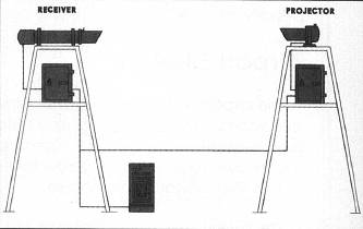
From this, visibility in hundreds of feet is calculated. Some locations will have as many as three separate transmissometers along one runway (reported as touchdown, mid-field, and rollout).
The minimum altitude associated with a precision approach (one with electronic glidepath information) is a decision height (DH). A non-precision approach utilizes a minimum descent altitude (MDA). If the glideslope is out of service on an ILS approach, the approach may be made as a localizer-only approach, in which case an MDA is used in lieu of the DH. On ILS charts, the no glideslope minima are reflected in the row labeled S-LOC, which stands for straight-in localizer only approach.
The practical difference between an MDA and a DH is a result of momentum. The FAA recognizes that an aircraft descending along the glideslope cannot arrest the descent at the DH if the decision is not made until the DH is reached.
On a non-precision approach, on the other hand, the airplane can be descended to and leveled at the MDA. Accordingly, the regulations state that "no pilot may operate an aircraft... below the authorized MDA or continue an approach below the authorized DH unless..." the requisite conditions concerning runway environment sighting, minimum visibility, and position are met.
If an approach is made to one runway with landing intended on another runway, circling minima must be used. The circling minima are always the same or higher than the minima published for a straight-in approach.
When certain components of an ILS approach are out of service (or if the airborne receiver necessary to identify certain components is absent or not working), the minima may be increased. Although there used to be a penalty for it, there is no longer a penalty for a middle marker being out of service.
Table of Contents
Previous Section: Profile View
Next Section: Airport Sketch