Microsoft Flight Simulator Handbook
by Jonathan M. Stern
RMS Technology's Flitesoft Pro
Flitesoft Pro is a flight-planning package from RMS Technology, Inc., of Oregon. Unlike the other computerized flight planners discussed in this chapter, Flitesoft Pro is a flight planner for use with real airplanes. It receives consistently high marks from reviewers in the aviation press.
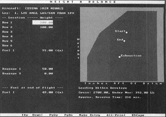
Flitesoft Pro does all the necessary flight planning, from selecting a route to retrieving weather information through DUATS. Flitesoft Pro also selects an optimal altitude, calculates performance, completes a flight log, and files a flight plan with the FSS. Flitesoft Pro calculates and graphically displays weight and balance (see Figure 15.5).
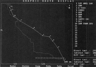
The nifty features of Flitesoft Pro include various graphical interfaces used in flight planning and course previewing (see Figure 15.6).
For example, there is a mode referred to as Virtual Flight in which the weather from DUATS and the actual topography along the flight planned route are displayed to allow a preview of the proximity to terrain and the expected weather conditions along the planned flight.
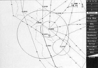
There are various ways to plan a flight with Flitesoft Pro. One way is to type the names of the departure and destination airports and let Flitesoft generate a route of flight along Victor airways or Jet routes. A second method allows the user to select the route of flight by pointing at waypoints on a detailed map of North America (see Figure 15.7).
Flitesoft chooses Great Circle routes, which, when compared with straight lines drawn on a map, reduce the distance between two distant points.
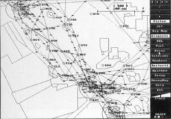
The flight planning map on Flitesoft Pro can display, at the user's selection, all Victor airways and Jet routes, airports, intersections, special airspace, and weather. See Figure 15.8.
Flitesoft Pro also knows all of the SIDs, STARs, and FAA preferred routes. Most of the maps and the flight plans and logs generated by Flitesoft Pro can be printed.
Flitesoft Pro comes with data (weight and balance and performance) for a large number of airplanes. For these purposes with Flight Simulator, both the Cessna 182RG and the Lear 35 are standard. The Lear 35, however, requires the use of a more expensive version of the software called Flitesoft Commercial. Although Flitesoft Pro is not inexpensive, it is a worthwhile investment for Flight Simulator users who also fly, or intend to fly, real aircraft.
For further information on Flitesoft, contact:
RMS Technologies, Inc.
124 Berkeley—P.O. Box 249
Molalla, Oregon 97038
1-800-533-3211
CompuServe I.D. 72163,3342.
Table of Contents
Previous Section: The Newfangled Way
Next Section: Navigator