IFR Flights of 13MIKE
by Fred J. Calfior and Douglas W. Miller
| Flight Scenario Two |

San Diego to Los Angeles |
(Southern California Area - estimated flying time 70 minutes)
Congratulations on your first venture into the world of no-see-um flying! It's not easy flying that AI is it? Well, the next flight is full of no-see-ums, so let's get at it.
This flight departs beautiful San Diego Lindbergh Field in the southernmost part of California, utilizing a SID, and concludes by shooting a VOR approach into smoggy Los Angeles International. You will need to plot your course on the Low Altitude Enroute Chart, fill out your flight plan, and answer a few questions. Then Professor Calfior will help you with the weather brief. I will step you through the setup where you will be setting the cloud level down to 1100 feet. Looks like you will be in the no-see-um conditions right after takeoff. Then back to Professor Calfior for the remainder of the adventure where he will entertain you with his easy going and humorous instruction. You need to listen to Professor Calfior's witty dialog (the jokes you can ignore) for all the good information that will help you become a better pilot and achieve a better score.
Our route of flight for this scenario has some interesting instrument procedures, so you will need to keep sharp.
FLIGHT PLAN -
This route of flight follows well established departure, climb, cruise, descent, and landing procedures. You will depart San Diego International, Lindbergh Field (Airport diagram in Appendix C2) on runway 27 at 2100 Zulu. You will fly a standard instrument departure procedure, or SID, called the HARBR TWO DEPARTURE. (Appendix C2)
As soon as practicable, you'll make a climbing right turn to a heading of 290 degrees, switch to San Diego Departure Control, and intercept Oceanside VOR's 154 radial inbound. Stay at or below 4000 feet until crossing CLSTR intersection, then continue your climb out to 7000 feet. You will be switched over to Los Angeles Center. You computed your true airspeed as 120 knots.
When intercepting the Mission Bay VOR 314 radial, turn left and track outbound until arriving at LNSAY intersection. At LNSAY, you should be at 7000 feet, and you will turn left, tracking inbound on the Santa Catalina 090 radial. Continue that track until arriving at HARBR intersection. From HARBR, proceed inbound on the Seal Beach VOR 148 radial to Seal Beach. Notice the coded name of this transition to Seal Beach.
Now Seal Beach VOR is the initial approach fix (IAF) for the VOR or TACAN or GPS RWY 25L/R instrument approach into Los Angeles. (Appendix C2) Under South California Approach Control's umbrella, you will descend to 4000 feet, flying outbound on the Seal Beach VOR 326 radial to FITON intersection, where the intermediate segment of the approach begins.
You'll turn inbound onto Los Angeles VOR's 068 radial (248 course inbound) and descend to 2000 feet by FREBY intersection. This is the final approach fix, and begins the final segment of the instrument approach procedure. At some point, you'll go to Los Angeles Tower. As long as you have DME capability, you'll descend to 620 feet by NOELE intersection, and then to your minimum descent altitude of 540 feet by the 2.7 DME missed approach point. If the field is in sight, you'll land straight in to runway 25L. If the field is not in sight, you will execute the missed approach procedure given in the profile view of the approach plate. Fuel on board is 5 hours and 50 minutes, and you've planned this out to be a 70 minute flight, so fuel is no problem. You've made a good choice in having Ontario International as your alternate.
Los Angeles International Airport's diagram is shown in Appendix C2.
FILLING OUT THE FLIGHT PLAN -
Fill out the following Flight Plan completely, carefully paying attention to your route of flight. Trace out your route using the IFR low altitude enroute chart L-3 given to you in Appendix B2.
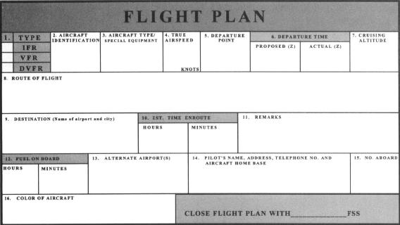
Now answer these questions from your flight plan and enroute chart.
** a) What is in block 8, Route of Flight, of your flight plan?
_________________________________________(10 pts)
** b) What restricted airspaces are to the right of you about 40 miles out from San Diego?
_________________________________________(10 pts)
** c) How many miles is it from Seal Beach VOR to Los Angeles VOR along Victor 23?
_________________________________________(10 pts)
** d) The name of the compass locator beacon southwest of Seal Beach VOR is what?
_________________________________________(10 pts)
** e) The minimum enroute altitude from Seal Beach VOR along Victor 8 to WILMA intersection is what?
_________________________________________(10 pts)
"Take a look at your airport diagram for San Diego International Lindbergh Field. On the left top corner, you will find that Lindbergh Clearance Delivery has a frequency of one two five point niner. At this airport, there is a pre-taxi clearance procedure available. That means pilots who are departing IFR can, if they want, receive an IFR clearance before even taxiing. It's not mandatory, but if one participates, they would call Clearance Delivery about ten minutes before they taxi, and the IFR clearance will be issued right then and there!
You will do just that. Before you even preflight the aircraft, you'll call up and get our clearance. Then you'll make your rounds about 13MIKE, and a taxiing we will go!
To start, you must call San Diego's Flight Service Station, and here's the local phone number: 277-3493. I happen to have it because it's listed, but from anywhere in the United States, you can always get a hold of a Flight Service Station by dialing 1-800-WX-BRIEF. You'll get relayed to the one closest to where you're calling from.
Okay! Have some fun, get the weather for this cross country flight, and file our flight plan as we've discussed."
Table of Contents
Previous Section: Flight Scenario One: Flight
Next Section: Flight Scenario Two: Weather Brief