Cross Country
by Alfred Poor
San Francisco
Flight 3
Big Mountains, Little Mountains
The last San Francisco area flight is a fairly simple, one-leg trip. The last flight ended up at Lake Tahoe, nestled among the mighty Sierra Nevada mountains. For this flight, you will head to Yuba County Airport in Marysville, California. One of the attractions in the Marysville area is the Sutter Butte, located about 15 miles from the airport. Sometimes billed as “the world’s smallest mountain range”, this is a collection of dark volcanic rock that rises nearly 2,000 feet above the otherwise level Sacramento Valley that surrounds it.
Planning a route
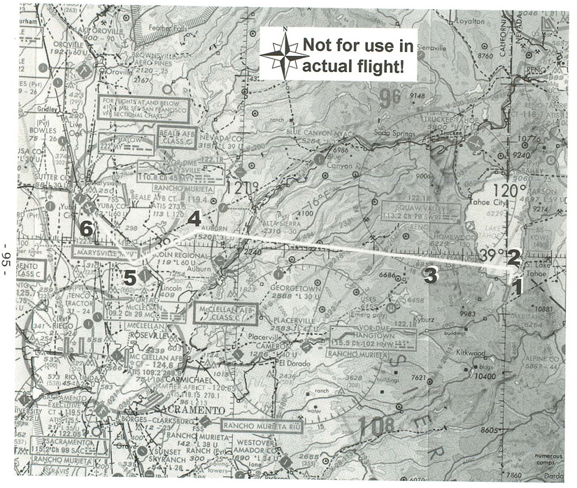
The detail from a WAC (World Aeronautical Chart) that we’ll use for our flight planning shows your route. For more detail, use the San Francisco Sectional chart, which uses a scale twice as large as the WAC.
The first thing you may notice is the dark shading all around Lake Tahoe at the right of the chart. This represents ground with high elevation, which pilots sometimes refer to as “cumulo-granite”; trying to fly through mountains is not recommended. The mountain range rises to nearly 10,000 feet above Lake Tahoe Airport—your departure point—and you’ll have to climb from the field elevation of 6,200 feet before you can head off over the mountains.
After you clear that first ridge, everything is downhill from there, to coin a phrase. The only other complication you’ll have to contend with is not physical, but legal. Notice that near your destination airport, Yuba County, there is a magenta circle around Beale Air Force Base. This indicates that there is a Class C airspace surrounding this field, and you cannot enter this airspace unless you are in contact with the air traffic controller for that area.
Since we don’t have simulated two-way radio for Microsoft Flight Simulator (well... at least we don’t have it yet!), you won’t be able to call up Beale Approach, and so you can’t go into that Class C airspace.
A look at the sectional provides some useful additional information, however. The Class C airspace goes down to the ground surface only for a five mile radius (that’s nautical miles) from the center of the Beale airfield, and for the next five miles, the airspace only starts at an altitude of 1,600 feet. So as long as you’re down to about 1,500 feet altitude before you get to within 10 miles of Beale, you’ll be okay. But in order to clear the five mile radius, you’ll have to approach Yuba County from the southeast at a heading of 290° or greater. Yuba County is relatively easy to find, since it has the Marysville VOR right on the field.
Finally, you’ll have to plan to start your descent well in advance. You’ll have to lose more than 10,000 feet between the time you cross the mountain ridges and when your wheels finally touchdown at Yuba County, so we’ll allow time for that in our flight plan as well.
|
The Flight Log
I have prepared a flight log for your trip. You’ll start on Runway 36 at Lake Tahoe, taking off towards the lake. (The lake is not present in the FS 5.1 scenery, but you can pretend that it is there.) The field elevation is 6,200 feet, so don’t be surprised if your take-off roll is longer than you are used to; the air is thinner at this altitude, so it takes a longer run to get up to speed.
You’ll also need to manage your speed carefully if you are going to make it over the mountain ridge to the west of Lake Tahoe. Trim the airplane so it flies at 70 knots, which should give you a climb rate of about 500 feet per minute or better.
Head out over the lake, and climb to at least 7,200 feet before turning on course—your heading will be about 260° or so. Maintain your 500 fpm climb rate as best you can, because you have a lot of altitude to gain before you can get over the mountains.
If you have the Mixture Control feature turned on in the Realism and Reliability command on the Sim menu, be sure to lean your engine every thousand feet or so in your climb. If you don’t, you might not generate sufficient power to make it over the mountains. Lean the engine by pulling back on the mixture control (the red knob) until the exhaust gas temperature (indicated by the EGT gauge on your control panel) hits a peak.
Don’t lean too much, or you’ll reduce power instead of increasing it. And if you do adjust the mixture, don’t forget to put it back to full rich before you get down to your landing pattern altitude at the end of the trip.
(If you see mountains around Lake Tahoe, then you probably have the FS 5.1 CD-ROM scenery enabled. If you don’t have this scenery enabled, you won’t see any mountains in the scenery, but you better climb anyway.)
How high should you climb? For VFR flights higher than 3,000 feet above the ground, you should travel at even thousands plus 500 when your heading is in the western half of the compass, and odd thousands plus 500 when headed in the eastern half of the compass. Since you’ll be flying west, the first altitude that will get you over the rocks is 10,500, so climb to that altitude before leveling off.
|
Watch out as you climb; if you use the default weather, there will be a broken cloud layer at 10,000 feet. Since you are flying under Visual Flight Rules (VFR), you must remain clear of the clouds. Find a hole to climb through in order to get on top of the layer, and then be careful not to fly over any clouds. (Unless you have the Cloud Thickness feature turned on, you won’t be able to see how high they stick up, and you can fly into them inadvertently.)
Continue on at this heading at this altitude for about 10 minutes or until you are clear the mountains. Then descend back down to 8,500 feet so that you get back under the cloud layer and don’t have to zigzag across the sky.
The pattern altitude for Yuba County is just over 1,000 feet, so you’ll have to lose 7,500 feet of altitude before you get there. It’s best to do this gradually over time rather than do an imitation of a falling brick at the last minute. A 500 fpm descent is a reasonable rate, so you will need to start at least 15 minutes before you reach the field. At 130 knots, this means starting about 35 miles from your destination. When the VOR DME readout for the Marysville VOR indicates 30 miles, just reduce your throttle to get the 500 fpm descent rate.
When the VOR DME readout shows about 20 miles, change the OBS setting to 295°; the needle will swing to the left of center. Change your course to 245° and continue straight until the OBS needle swings to the center of the gauge; it should start to show some movement after a few minutes on the new course.
When the needle centers, turn to a heading of 295° to follow the radial to the airport. When you see the field, you can swing over to the west a bit and line up for a straight-in approach for runway 32. Set up for your landing, and grease it on the runway to complete your trip.
Getting ready to fly
There is no entry for Lake Tahoe on the World Airports list, so you’ll have to use the Set Exact Location feature. Here are the values you will need to enter:
North/South Lat.: 038 52 58.1
East/West Lon.: 119 59 54.9
Altitude (ft): 6266
Heading: 360
These settings will put you on the displaced threshold of runway 36 at Lake Tahoe. While you are not supposed to land on a displaced threshold, you can use it for your takeoff run, and at this altitude, you’ll want to use all the runway you have.
Tune your NAV1 radio to the Marysville VOR frequency of 110.80 (in the real world, you wouldn’t be able to receive the signal until you clear the mountains, but FS 5.1 makes it a bit easier for you.) Set the OBS heading to 260°—the needle should be approximately centered on the gauge. And make sure that you have the DME readout for NAV1 showing nautical miles (and not speed in knots).
And with this, you should be ready to fly. Double check your settings, and then when you’re ready, advance the throttle and take off! Just remember that if you can get over these big mountains in the beginning of the trip, you can go sight-seeing and visit the little ones at the other end.
< Situation file: XC-SF3
Table of Contents
Previous Section: Lake in the Mountains — Columbia to Lake Tahoe
Next Section: Section E: Seattle