Cross Country
by Alfred Poor
Seattle
Flight 2
A Sound Plan
|
|
There’s an old folk song about Puget Sound, with a final refrain that goes “surrounded by acres of clams”. If you’re a fan of fresh seafood, from salmon to shellfish, then you’ll want to head on out to the Pacific Northwest for a visit.
For this flight, you’ll take a scenic tour of Puget Sound, flying up to Harvey Field in Snohomish, Washington. You can camp right on the field and then take the short trip to nearby Everett for a tour of the Boeing aircraft factory.
Planning a Route
You can turn off the radios on this flight because you’ll be relying solely on your DG (directional gyroscope) and your Mark I Eyeball to find your way. And in the process you’ll get an up-close and personal tour of Puget Sound.
How close? Well, the Seattle area is not known for its sunshine or arid climate. It does rain there a bit, and it’s often cloudy. For this flight, I’ve set you up with a solid overcast to fly under—there’s still plenty of room for safe VFR flight, but don’t let your altitude drift away from you or you’ll end up in the soup above or the drink below!
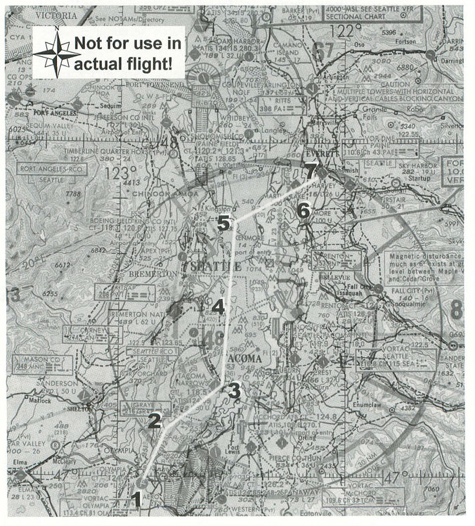
The route from Olympia to Harvey Field is highlighted on the section from a WAC (World Aeronautical Chart); in order to see more detail, you might want to use either a Seattle sectional chart or a Seattle Terminal Area Chart which show the same area in a larger scale.
You will start from Runway 26 at Olympia, then fly up towards the Tacoma Narrows Bridge. You could continue on in a straight line to go to Harvey, but this route would take you close to the heart of the Seattle Class B airspace, and you’d have to get down below 1,800 feet to avoid busting this special airspace. Instead, let’s cut you some slack so you can enjoy the flight while remaining clear of the most active airspace.
After passing the bridge, you’ll turn north and fly along the Colvos Passage between the mainland and Vashon Island. Once you reach the northern tip of Vashon Island, you will turn a bit to the left and fly past Bainbridge Island. This is easy to spot because it has three distinct bays along its eastern shore. Just beyond Bainbridge Island, there is a large point sticking out into the sound towards the east. Once you reach this, you can safely turn back to the northeast and head toward Harvey. One convenient checkpoint along this leg is Martha Lake Airport; Harvey Field is just six miles further on. The airport is nestled into a bend in the Pilchuck River, and as the old saw goes, “when you cross the river, you’ve gone too far.”
This route is all laid out for you in the flight log. Note that the headings are approximate; you’ll be relying on visual references to make adjustments to your course headings.
Next comes the question of how high to fly. The Class B airspace is arranged in layers, and the portion over Vashon Island and the Sound where you will be flying has a floor of 3,000 feet MSL. You can tell this by the “fractions” on the chart; the indication of 100 over 30 means that the airspace extends from 3,000 feet (30 hundred feet) to 10,000 feet (100 hundred feet) above mean sea level.
|
You’re not going to fly over that—not without spending an inordinate amount of time climbing and circling outside the Class B airspace—and even if you did, you’d be faced with a 10,000 foot descent at the other end to get to Harvey Field which is just under the outer edge of the airspace on the other side.
As a result, the only practical approach is to go under the airspace. Since this is Seattle, we have also dialed in a low overcast for the flight to add some realism and to help you visualize the Class B airspace; stay out of the clouds, and you stay clear of the airspace.
With a ceiling of 3,000 feet, Visual Flight Rules require that you remain at least 500 feet below the clouds (or 1,000 feet above, or 2,000 to the side). This is designed to give you and the other pilot a moment to react when a plane flying under instrument rules (IFR) pops out of the clouds headed in your direction. A look at the chart shows that there are no obstacles along your route that are higher than 1,000 feet, but you want to fly high enough to give you some gliding distance in the unlikely event that something goes wrong. So plan to cruise at 2,250 feet. (Note that the “hemispheric rule” that dictates cruise altitudes based on your course does not apply, since you will be flying less than 3,000 feet above ground level.)
We are ignoring one airspace requirement on this flight, but you can act it out if you want to remain strictly legal. The dashed line around the Tacoma Narrows Airport indicates that it is Class D airspace with a tower. The airspace extends up to 2,800 feet MSL, and you will be flying right through it. (You also have McChord Air Force Base with its own Class D airspace to the right of your course, and the Tacoma Narrows Class D airspace extends pretty far to the west, which make a detour impractical.) To stay legal, you need to be in radio contact with the Tacoma Narrows Tower before you enter the airspace. So tune your COM1 to 118.5, and give out your airplane’s N-number and your position, and ask for permission to transition the Class D airspace over the bridge. All you need to hear is the controller repeat back your N-number and you can continue on your merry way.
|
The only other point to consider is your descent at the other end. The pattern altitude for Harvey Field is 800 feet, which means that you will need to lose 1,450 feet. At a standard 500 fpm descent rate, that means you will want to start down three minutes (or more) before you enter the pattern. At 130 knots—the airspeed I used for the flight plan—that means starting 6.5 nautical miles out. Conveniently, this is almost exactly the distance from Martha Lake Airport to Harvey Field, so set up your descent before you cross Martha Lake and you should be ready to enter the pattern at your destination.
I’ll assume for this flight that the winds are light and variable out of the northwest, so you will depart from Runway 26 at Olympia, and land on Runway 32 at Harvey Field. There are a couple of details to note about your destination, by the way. First is the fact that pattern altitude is just 800 feet, which is lower than the standard 1,000 feet used at most airports, so your view of the field will be a little different than you are used to seeing. You may have a tendency to fly the pattern too close to the field. The other detail is that the paved runway is just 36 feet wide—only 25% the width of Olympia’s runways. This narrow landing strip can also mess up your visual picture of the situation, and you may find yourself flaring too late on the landing. (No, you cannot log each bounce as a separate landing, either!) You’ll be a safer pilot if you think ahead about details such as these before your flights.
Getting Ready to Fly
Set up for this trip is easy. Start up FS5.1 and choose the Airports command from the World menu. In the “Choose a scenery area:” box, select “USA - Seattle”. Then pick “Olympia - Runway 26” from the list of airports.
Next, you need to set up the cloud cover. Choose Weather from the World menu, and then Edit the cloud layer. Change the Base setting to 3000 feet, and the Coverage to Overcast. Choose OK twice to return to the simulator.
If you want to make the trip more challenging, here are two modifications. First, you can add some wind. Try a 15 knot breeze from 270°, in a layer from 1,000 to 3,000 feet. (You can even bring it down to ground level if you want to practice cross-wind take-offs and landings.) Also, you can add some patchy fog to the Sound by Creating an extra cloud layer; try a global layer from 100 feet to 1000 feet with a 100 foot deviation. You won’t have any trouble getting up and down while remaining clear of the clouds, but it can make spotting your visual references a little more difficult.
Take Off!
That’s it—you’re ready to go sight-seeing over Puget Sound. Have a great flight, and enjoy the view. But be sure to get your seafood after you get to the airport, and not en route—unless you have floats mounted, a Cessna makes a pretty poor fishing boat!
< Situation file: XC-SE2
Table of Contents
Previous Section: Airport Hopscotch — Olympia local flight
Next Section: Head for the Mountains — Harvey to Pierce County