Cross Country
by Alfred Poor
Seattle
Flight 3
Head for the Mountains
|
|
I guarantee that you’ll have a fair flight for this trip, no matter what the weather.
How can I be so certain? Because you’re going to the Fair—the Puyallup Fair. The last flight in this area ended at Harvey Field, north of Seattle, and on this flight you’ll backtrack down to Pierce County-Thun Field which is nearly due south of Seattle. This airport is located outside of Puyallup; the town name comes from a pair of native American words that mean “friendly people”.
You might want to visit Puyallup for its annual Daffodil Parade, but the big draw is the Puyallup Fair—first held in 1900—that runs for 17 days each fall, attracting more than 1.3 million visitors to its farm exhibits, crafts, food, rides, and free entertainment. Plan on riding the Ejection Seat or the Skycoaster, and then enjoying a few Fisher scones—dripping with butter and raspberry jam—that have been a tasty part of the fair since 1915.
Planning a Route
Your route is highlighted on a portion of the Seattle sectional chart. Notice the patchwork of blue lines surrounding Seattle-Tacoma International Airport (SEA). These lines mark the Class B airspace that surrounds the airport, and you cannot enter it without air traffic control’s (ATC) permission. Since we don’t have interactive voice communications with ATC in the default version of FS5.1 (well, at least not in this version), I plan your flights so you don’t have to talk to the controllers.
The “fractions” in the different Class B segments indicate the ceiling and floor of the airspace. For example, the “100/80” indicates that the Class B airspace starts at 8,000 feet (80 hundreds) and ends at 10,000 feet (100 hundreds). Right around the airport itself, the airspace extends down to “SFC”: the surface of the ground itself. Because the Harvey and Pierce fields are both under the Class B space, it makes no sense to climb over the ceiling, so instead I’ll plan a route that goes under it.
If you travel due south (true, not magnetic) from Harvey Field, you’ll notice a line running north and south. The Class B airspace extends down to 3,000 feet to the west of that line, but has a floor of 5,000 or 6,000 just to the east of it. Fortunately, there is a major landmark you can use to stay on the east side of that line: Sammanish Lake. There are also some hills—maximum elevation of 3004 feet—just east of the town of Issaquah, which should make a big target.
Once you cross the highway at Issaquah (Interstate 90), you could turn directly toward Pierce County-Thun Field, but just to make certain that you don’t tangle with any approach or departure traffic from SEA, I’ll keep your route a bit to the east. How can you know when it’s okay to turn toward your destination? You can use the VOR beacon at McChord Air Force Base; by tuning the OBS on your NAV radio to 255, you’ll know when you have crossed the 255º radial, which you can then follow until you see the airport.
|
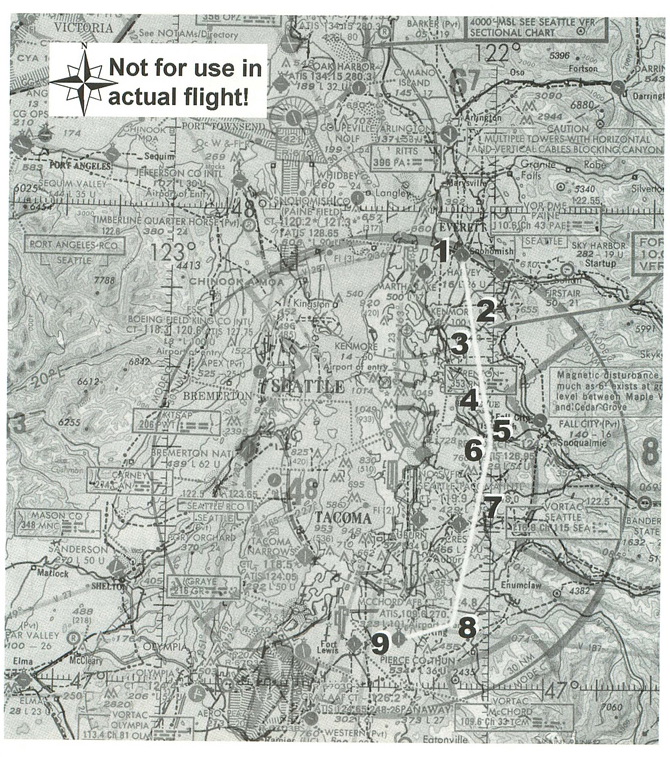
The next question is how high you should fly. You want to make sure that you have room to spare when you near the high ground at Issaquah, but this is a short flight and there’s no sense in climbing up to the base of the Class B airspace. So I’ve planned a cruise climb (at 80 knots) to 3,500 feet for the first leg; this complies with the hemispheric rule that states that VFR traffic on a heading between 0 an 179 degrees should cruise at altitudes of odd thousands plus 500 feet, and you’ll be headed slightly east of south.
Once you make it through the pass at Issaquah, you’ll need to descend to 2,500 feet, since the floor of the Class B airspace is only at 3,000 feet in places along the second leg. (The hemispheric rule does not apply here because you will be less than 3,000 feet above ground level.) And when you turn toward the airport for the final leg, descend further so that you are at the pattern altitude of 1500 feet by the time you are ready to enter your downwind leg for a landing.
Setting Your Course
I have prepared a flight log for your flight, which lists a series of visual checkpoints that you will be able to use to keep track of your position as you make your way along the route.
You’ll depart Harvey Field on Runway 14, and after you climb to 1,000 feet, turn to a heading of about 155º. This should point you roughly at the western edge of the hills at Issaquah; you’re aiming for the pass between the last two peaks on the right, but remember to stay to the left of Sammanish Lake.
You may wonder about that 155º heading; the course on the chart looks like it’s nearly vertical, which would lead you to expect a heading of somewhere between 170º and 180º. Magnetic north is not in the same location as the north pole, however, so there is what’s called a “variation” between true and magnetic headings. In some parts of the country, this variation can be quite small, or even zero. In the Seattle area, however, the variation is extreme; magnetic north is nearly 20º to the east of true north. Thus a magnetic heading of 155º will point you almost due south.
|
Your first checkpoint will be Route 522. Next, you’ll cross the road between Woodinville and Duvall. There’s a road that you’ll cross near Sammanish Lake, but the north end of the lake makes a better checkpoint. Past the southern end of the lake, you’ll cross Interstate 90 at Issaquah, and then head between the two hills. Once through the pass, turn to a heading of 170º, and start to descend. You’ll cross Route 169 near Cedar Grove, and then Route 18 near Maple Valley. Continue on course until the OBS needle centers on your NAV1 radio, and then head 255º until you see the field. Then swing to the west to make a 45-degree entry on a left-downwind leg for a landing.
Getting Ready to Fly
Harvey Field isn’t on the World Airports menu list, so you’ll need to place your airplane there yourself. Use the World Set Exact Location command, and enter the following values:
North/South Lat.: N 47 54 31.9
East/West Lon.: W 122 06 11.7
Altitude (ft): 19
Heading (deg magnetic): 140
This will place you at the end of Runway 14, ready for take-off.
Then tune your NAV1 radio to 109.60, and set the OBS to 255; this will set the radio to the McChord VOR, and you can make the turn from the second to third legs when the OBS needle centers. (If you want, you can tune your NAV2 radio to 116.80, which is the SEA VOR; you can then use the DME readout for NAV2 to monitor your distance from the airport, which can help you locate your position relative to the boundaries of the Class B airspace.
Make certain that your transponder is set to 1200, the squawk code for VFR flights. This would be a good time to use the Options Save Situation command to save these settings so that you can load them again when you want to fly this flight again.
And now you’re ready to roll. Head for those mountains, and enjoy a “Fair” day when you reach your destination.
< Situation file: XC-SE3
Table of Contents
Previous Section: A Sound Plan — Olympia to Harvey Field
Next Section: Part II: Optional Add-On Scenery Areas