Cross Country
by Alfred Poor
Hawaii
Flight 3
Vulcan Visit
Hawaii is famous for its sun, sand, and surf, but it’s also well-known for its many volcanoes—many of which are still active. This flight gives you an up-close and personal look at the highest peak on Maui, plus lands you on the “Big Island” of Hawaii at Upolu Point, birthplace of King Kamehameha who ruled the chain of islands.
Planning a Route
The section of the chart shows your route for this trip, which will combine some simple pilotage, some VOR navigation, and a long stretch of over-water flight.
The chart also shows a symbol that is a bit unusual. Notice the wedge-shaped symbols around the Haleakala volcano. These represent hang gliders, and are used to mark areas where hang glider activity is particularly heavy. With their steady winds and rugged topography, the Hawaiian mountains make particularly attractive places to jump into the sky with a large kite strapped to your back (if you are the type of person who finds that type of activity attractive). So be alert for hang gliders in your area as you fly near these regions.
|
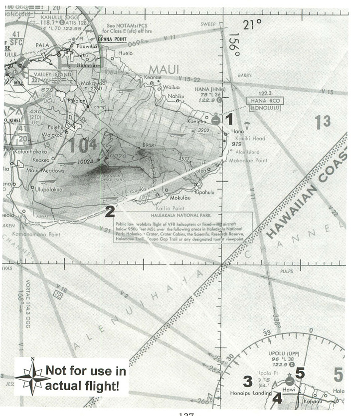
Your starting point is Hana Airport on the northeast corner of Maui, and you could simply plan a straight shot across the Alenuihaha Channel over to Hawaii, but that would give you about 30 nautical miles of over-water flight with no time to gain altitude before leaving land. Instead, I’ve planned your route so that you gain some gliding altitude before you go “feet wet” and have a chance to tour Haleakala a bit in the process.
You’ll depart Hana and head west, climbing as you go. You’ll circle the mountain counterclockwise as you climb, and then pick up the 128º radial for the Upolu VOR (112.3). You still will have a 30-mile crossing over the channel, but you will be able to climb to 7,500 feet (or higher, if you want) so that you will be able to remain within gliding distance of land for at least half of the flight.
There are a few special airspace considerations for the flight. There is a Class C area around Kahului Airport west of Hana. Two sectors stick out to 10 nm from the field, with ceilings of 4100 feet, but if you stay close to the mountain as you climb, you should remain well to the east of these areas.
You will find a dotted line inside the boundaries of the Haleakala National Park, which means that you are requested to remain at least 2,000 feet above the ground level. According to the chart, however, you must be at least at 9,500 MSL altitude over certain areas of the park, so to avoid these restrictions over the eastern side of the mountain, I have planned your route around the western side.
Flying the Plan
The flight log for this trip is fairly simple. You will depart from Runway 26 at Hana Airport, and climb as you head west. Follow the contours of the volcano as you fly, keeping at least 500 feet above the ground level as you go. (1,000 feet is even better, since this gives you more time to make plans in the event that you have to make an emergency landing.)
|
After 15 minutes, you will have traveled about 20 miles and will be at 7,500 MSL altitude. This will be sufficient to let you level off to a 130-knot cruise speed and then follow the 7,000-foot contour of the volcano around to the southwest. Note that the peak of the volcano will still be 2,500 feet above to your left. Once you clear the ridge, turn to the southeast until you intercept the 128º radial of the Upolu VOR.
At 130 knots, it will take you just under 14 minutes to cross the channel. If you were to start a 500 fpm descent the moment you left Maui’s shoreline, you’d be about at pattern altitude when you got to the other side, but you’d end up spending most of your flight out of gliding distance from land. As a result, it would be better to wait until you were within 7 miles of land before starting your descent. You can use the DME readout for the VOR to judge your distance; the VOR is about 3 miles inland, so start your descent when the DME indicates 10 nm.
Even if you slow way down during your descent, you will still have lots of excess altitude when you make landfall. Plan on making a number of slow 360-degree spiral turns once you reach land to shed this excess altitude, maintaining a comfortable 500 fpm descent rate.
You should make landfall aimed right at a tall red and white tower. Aim for this as you get down toward the pattern altitude of 800 feet, and then head east to the airport. Enter a right downwind leg (over the water) for a landing on Runway 25.
Getting Ready to Fly
There is an entry for Hana Airport in the World Airports... menu for Hawaii, but it places you on Runway 8. You can either back-taxi to the other end of the runway, or use the following entries with the World Set Exact Location command to place you in position on Runway 26.
North/South Lat.: N 20 47 41.7
East/West Lon.: W 156 00 31.4
Altitude (ft): 80
Heading (deg magnetic): 255
Then tune your NAV1 radio to 112.3 for the Upolu VOR, and set the OBS to 128º so you can intercept that radial as you round the volcano.
With that, you should be ready to rock and roll. Enjoy your flight, and be sure to say hello to King Kamehameha (or at least his statue) when you get to the Big Island.
< Situation file: XC-HA3
Table of Contents
Previous Section: Triple Play — Kapalua to Kalaupapa
Next Section: Section B: Las Vegas