Cross Country
by Alfred Poor
Hawaii
Flight 2
Triple Play
|
|
Three islands in one flight: that’s your goal on this flight. You’ll start on a private airport on the beautiful shoreline of Maui, cruise over to Lanai—one of the smallest inhabited islands in the chain—and then another short water crossing to your final destination on the north shore of Molokai.
Your landing will be at Kalaupapa National Historical Park. Among the sights there are the former leper colony, which a Belgian priest, Father Damien, helped develop in the last century. He worked among the lepers to build a hospital, farm, and other facilities. While you’re there, you can also enjoy a hike on the trails in the park.
Planning the Route
As you can see in the section of the chart, there is a VOR beacon conveniently located on Lanai, so navigation will be simple. You can fly directly to Lanai on one radial, and then back out another to find Kalaupapa.
There are no airspace restrictions that you need to be concerned about for this trip; the dotted circles around the Kapalua and Lanai airports represent Class E airspace (which is printed in magenta on the real sectional chart, but you can’t tell that from the black and white image shown here). You do not need to make any radio calls in this airspace under VFR conditions.
The only complications come from questions of altitude. The first one has to do with mountains in your path.
A direct line between Kapalua and Lanai airports takes you almost right over the 3,367 foot-high peak on the east side of Lanai. You could fly high enough to cross above it, but then you’d be faced with a slam dunk approach into the airport, about 2,000 feet below. A better idea might be to swing along the shore of the island to the south of the mountain, and get a clearer shot at the runway without having to act like a dive bomber.
There is also a sizable ridge—nearly 5,000 feet high—in the eastern half of Molokai which poses a similar problem. If you were high enough to clear the ridge, you’d then be faced with a dramatic descent down canyons to reach the sea-level airport. The lines with dots inside mark the national park boundaries, and indicate areas where pilots are requested not to fly lower than 2,000 feet AGL (above ground level) to reduce engine noises for those on the ground. So I’ve planned for you to take the long way around, swinging around the eastern end of the island to get to the airport.
The other altitude consideration is one that you must think about any time you fly over water—especially in a single-engine craft. What will you do in the unlikely event that the fan in the front stops turning? It’s an extremely rare occurrence, but it’s better to plan for the possibility and not have it happen, than the other way around.
By maintaining altitude in your water crossing and minimizing the distance over water, you can maximize your gliding distance and your chances of reaching dry land should you encounter engine troubles. Figure on about a mile per thousand feet of altitude (you can actually do better than that, and it’s something worth practicing when you have a chance).
|
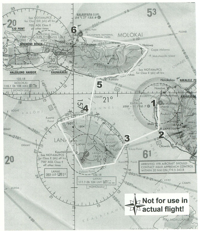
If you were to fly direct from Kapalua to Lanai, you’d travel nearly 10 nm over water. Instead, travel down the coast a bit to Lahaina, and your crossing will be only about 7 miles, which means that a 3,500 cruising altitude will put you within gliding distance of land for your entire crossing.
In a similar vein, you can follow the coast of Lanai after leaving the airport there, and then follow the 0º radial from the VOR to Molokai, for a crossing of about 7 miles which means that your 3,500 foot cruising altitude will work there as well. Once you’re safely across the Kalohi Channel and over Molokai, you can drop down to about 2,000 feet for a good sight-seeing altitude.
The flight log for this flight is fairly simple. You’ll fly down the coast of Maui until you intercept the 235º radial of the Lanai VOR, then head out across the Auau Channel. With a cruise climb of 80 knots from take-off, you will need to continue your climb for a few minutes after you make your turn at Lahaina, and then you can level off at 3,500 feet altitude and 130 knots cruise speed.
Once on the other side, follow the island coast to the south and continue around until you see the airport inland. I have not included the stop at Lanai airport on the log—if you feel like stopping off for lunch, go right ahead, and then pick up the flight after your break.
Then you’ll retune the OBS on your NAV1 for the 0º radial, and follow the Lanai coast around to the northern side. When the needle centers, strike out across the Kalohi Channel for Molokai. Then turn right and follow the coast around until you reach the Kalaupapa airfield and the park. Plan on landing in the same direction as you took off, which means you’ll want to use Runway 23. This runway has a right-hand traffic pattern, so fly out over the water to enter the pattern with a 45-degree entry onto a right downwind leg for your landing.
Remember to start your descent to the airport early enough so that you’re at the 800 foot pattern altitude by the time you reach the field.
|
Getting Read to Fly
You can use the World Airports... menu command to place your airplane on Runway 20 at Kapalua on Maui. The only adjustment you will have to make to those settings is to make certain that your NAV1 radio is tuned to the Lanai VOR (117.7) and that the OBS is set to 235º.
That’s all there is to it. Enjoy your lunch at Lanai, if you should decide to stop there, and have a great time touring the coasts of these three Hawaiian islands.
< Situation file: XC-HA2
Table of Contents
Previous Section: A Spin Around Niihau — Princeville to Port Allen
Next Section: Vulcan Visit — Hana to Upolu