Cross Country
by Alfred Poor
Las Vegas
Flight 1
Lake Cruise
Surrounded by desert, your first flight in the Las Vegas region is going to be spent largely over water. As improbable as this may seem, your route will take you along more than 30 miles of Lake Mead, a giant man-made lake on the border between Nevada and Arizona. You’ll need sharp eyes to complete this flight successfully.
Planning a route
As shown in the section of the chart, your route starts at Perkins Field in Overton, at the north end of Lake Mead. You’ll follow the western shoreline down past Echo Bay (where you can stop off at Echo Bay Airport for lunch at the Tail of the Whale restaurant if you can find the airport), then across the fork in the lake to the airport in Temple Bar, Arizona. It’s a short flight, suitable for sight-seeing along the lake. Just keep in mind that the lower you fly, the harder it can be to spot your destination.
|
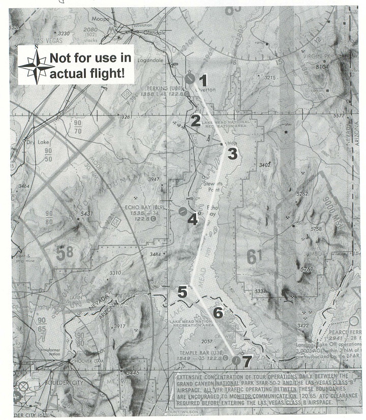
I’ve created a flight log for you that shows the waypoints that you can use to keep track of your progress. Departing from Runway 13 at Perkins Field, you’ll be able to climb out toward Lake Mead. The entire area is a national recreation area, and the dots inside the boundary line indicate that aircraft are requested to fly at least 2,000 feet AGL over those areas. Since the lake’s surface is at 1,200 feet, I’ve planned your route for 3,500 feet.
The route is fairly easy to follow. Just keep to the right-hand shoreline as you go. You’ll turn the corner at Overton Beach, across from where the Virgin River joins the lake on its eastern shore.
A bit further down the lake, you’ll see Jumbo Peak on the eastern shore, and Echo Bay below you on the western shore. If you’re feeling like taking a break, head west and land for lunch at Echo Lake Airport (the Tail of the Whale restaurant is just three miles from the field). It can be a tough airport to spot, however, so check your landmarks carefully.
I’ve assumed that you’ll continue on your way, however, without the break. Follow the western shore all the way down to the point where it turns right to the west towards Las Vegas; you’ll turn left and head out across the lake for the southern shore. Halfway across, you’ll leave Nevada and enter Arizona.
You’ll cross over a large point of land, and then a bay on the other side. Your destination, Temple Bar Airport, is located on the other side of the bay, and in a mile or two from the shoreline.
In spite of the fact that you’re flying over some pretty deserted territory, it is still difficult to spot the airports in this scenery. To prevent an unplanned trip to Phoenix, it’s a good idea to build a fence in the sky to help you find the airport. In this case, you can use the VOR at Boulder City (BLD 116.7) to keep you from going past the airport. The airport is located on the 72º radial, 25.8 nm from the VOR. So if you tune your NAV1 radio to the beacon and then set the OBS to 252º (so that you get a TO reading on the OBI), you can watch the needle to help you find the airport. When the needle centers, you should be close to the airport.
|
If the DME readout shows less than 25.8 miles when the needle centers, then the airport will be east of your position. If the readout shows a greater distance, then the airport is west of you. This extra help should make it easier to find the airport on the first try.
Flying at 3,500 feet, you’ll have just a bit more than 1,000 feet of altitude to lose to get down to the pattern altitude at Temple Bar. At 500 fpm, you’ll want to start your descent at least two minutes from the airport. According to the flight plan, starting your descent when you reach the southern shore of Lake Mead should work out fine.
Once you find the airport, plan on entering a right downwind leg for Runway 18. And don’t forget the note in your flight log—you don’t want to end up in an argument with a steer on short final, so keep a sharp lookout when you’re landing.
Getting Ready to Fly
This is an easy flight to prepare. Just pick the Perkins Field from the Las Vegas scenery list of airports in the World Airports menu. This will place you in position for takeoff on Runway 13. All you have to do is set your NAV1 radio to the Boulder City VOR (116.7) and set the OBS to the correct radial (252º).
With that, you’re all ready to fly. Enjoy your over-water flight in the middle of a desert!
< Situation file: XC-LV1
Table of Contents
Previous Section: Section B: Las Vegas
Next Section: Making a Pass — Temple Bar to Henderson Sky Harbor