Cross Country
by Alfred Poor
Las Vegas
Flight 2
Making a Pass
The Las Vegas Strip is a world-famous attraction, and you can hardly plan a trip in this scenery without getting close enough to visit it. The problem is that the downtown airport—McCarren International—is surrounded by Class B airspace. While it’s true that small general aviation aircraft are welcome there, you still must contact air traffic control for clearance into the airspace, which eliminates McCarren from our list of potential destinations.
Fortunately, Las Vegas has lots of small airports, some of which are quite close to the action. I’ve planned this trip to Henderson Sky Harbor Airport, which is less than 10 miles away from The Strip.
I’ve planned this trip for daylight, but you can increase the challenge and enjoy a view of the lighted city from a distance by flying at night.
|
Planning a Route
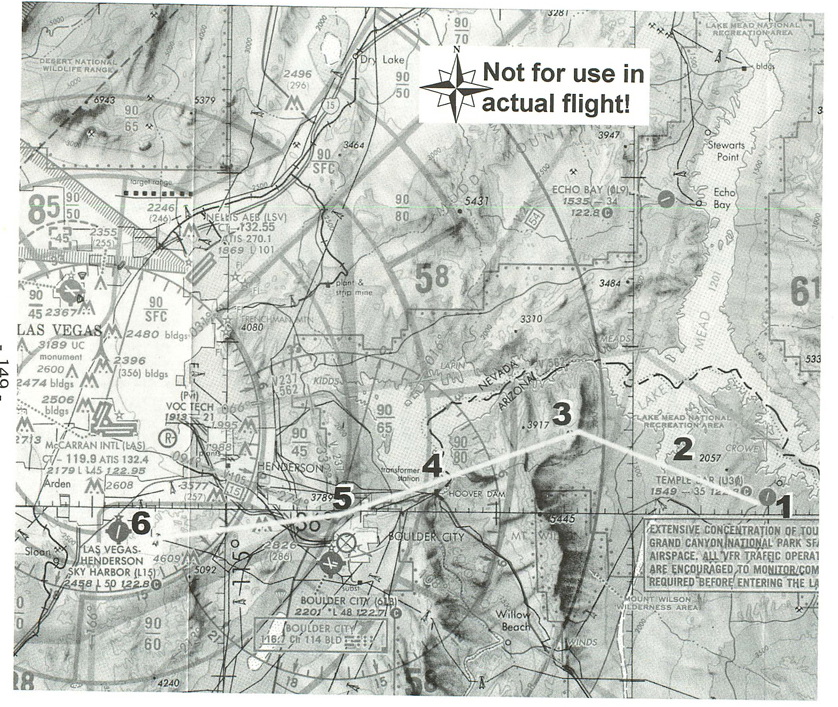
The flight begins in Temple Bar, where the last flight ended. A look at the section of the chart shows the route I have planned for you.
Notice that the trip could have been shorter if I had taken a straight line between the two airports. The problem with this route is that it would take you over the high point on the mountain ridge east of Boulder City. At 5,445 feet in elevation and surrounded by national recreation area, this bit of rock would mean that you’d have to climb to at least 7,500 feet for just a forty-mile flight.
A detour to the south of the ridge would let you fly a lot lower, as would a route that would take you back along the southern shore of Lake Mead. These both add a lot of extra distance to your route, however. Instead, I’ve chosen a path that goes through a notch in the ridge, called Indian Pass. (The pass is shown in greater detail on the Las Vegas Terminal Area Chart, which comes as part of the documentation for the scenery package.) The pass has a maximum elevation of just 3,268, which means that a cruising altitude of 5,500 feet will keep you above the recreation area, but you won’t have to go too far out of your way or spend the whole trip climbing.
The flight plan that I have prepared for this trip shows you the key checkpoints and headings for the flight.
You’ll take off from Runway 36 at Temple Bar, and climb as you head for the pass. You’ll head about west until you intercept the 235º radial for the Boulder City VOR (116.7). Turn to follow the VOR, and it will take you right through the pass. Continue to track the VOR radial, past the Hoover Dam, until you reach the beacon.
Then reset your OBS to 250º, and follow that heading. Henderson Sky Harbor is 13 nm from the VOR.
|
Your cruise altitude of 5,500 feet should be adequate for all of the en route portions of the trip. As shown on the chart, the floor of the Las Vegas Class B airspace is down to 5,000 feet by the time you reach Henderson Sky Harbor, but you will have started your descent to pattern altitude well before that, so you should have no problems with the special use airspace requirements.
Pattern altitude at the airport is 3,200 feet, so you’ll have nearly 2,500 feet to lose from your cruising altitude. At a 500 fpm descent rate, you’ll want to start at least five minutes before you arrive at the airport, which works out to about 11 miles at a speed of 130 knots. So plan to start your descent when you make your turn at the Boulder City VOR, and you should be at pattern altitude within a couple of miles of the airport.
When you get there, watch out for the heavy sight-seeing traffic bound for Las Vegas and the Grand Canyon, as well as airline service. You’ll be landing on Runway 36, but keep in mind that the Class B airspace goes all the way down to the surface just about a mile north of the airport, so be careful not to bust the boundary if you have to go around on a landing attempt. It’s a standard left traffic pattern for Runway 36, so plan on entering a left downwind leg as you approach the field.
Getting Ready to Fly
Preparation is simple; pick Temple Bar from the Las Vegas list in the World Airports menu. The only other setting you have to make is to tune the NAV1 radio to the Boulder City VOR (116.7) and set the OBS for the 235º radial.
With that, you’re ready to head to The Strip and try your luck. Just remember to keep some get-out-of-town cash safe in your shoe, so you can pay the FBO fee when you’re ready to leave town.
< Situation file: XC-LV2
Table of Contents
Previous Section: Lake Cruise — Perkins to Temple Bar
Next Section: Leaving Las Vegas — Henderson Sky Harbor to Tahoe