Cross Country
by Alfred Poor
New York A
Flight 2
I Follow Roads
Los Angeles may have the reputation of “Freeway Capital of the World”, but metropolitan New York is a prime contender for the title. There are enough highways, freeways, beltways, parkways, turnpikes, and other fancy-named rush-hour parking lots to confuse even the native drivers.
Not only does flying let you rise above the mundane frustrations of bumper-to-bumper transportation, it also lets you take advantage of those concrete ribbons to help you find your way. Granted, the roads are not labeled so you can identify them from 2,000 feet up (and they’re rarely identified by name or number on charts, either) but they still can be useful for navigation.
Unfortunately, not all the roads are shown in the New York add-on scenery, so you’ll have to add some ded reckoning and radio navigation to the mix in order to make it from Linden Airport to Lincoln Park.
|
Planning a Route
It would be great if you could simply head off in a straight line from Linden to Lincoln, but the FAA regulations don’t make that easy. In addition to the complex Class B airspace that blankets the area, you also have other special use airspace to consider.
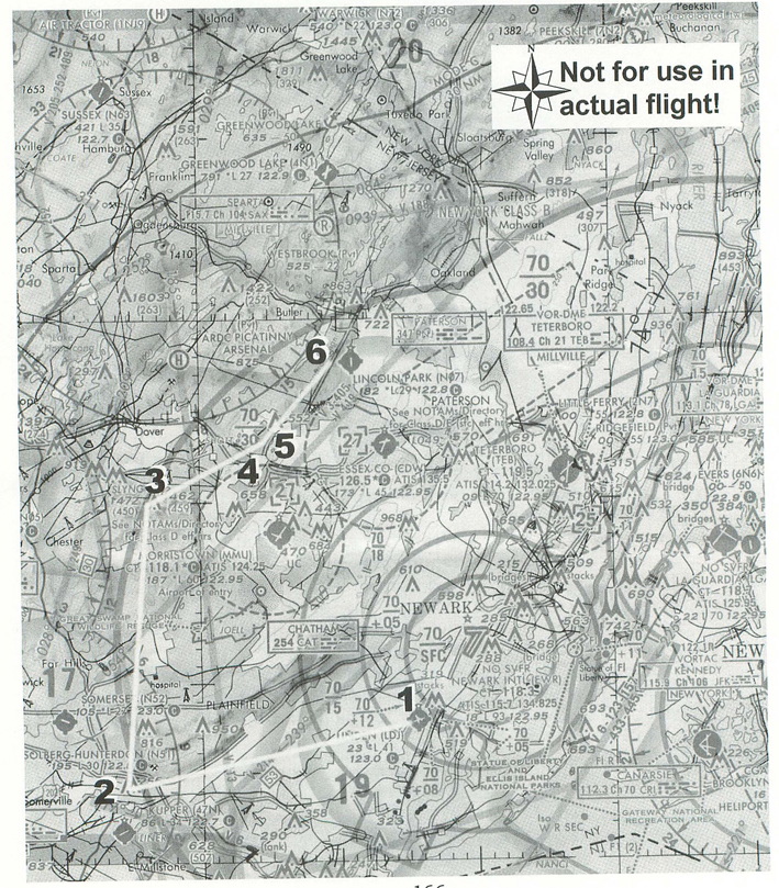
The section of the chart shows the route I have chosen for your flight. Notice the dotted circles around the Morristown and Essex airports; these represent Class D airspace, and the “27” notations within the broken squares indicates that the airspace extends up to an altitude of 2,700 feet. The floor of the Class B airspace in this area extends down to 3,000 feet, which offers only a thin layer for passage where you don’t have to talk to an air traffic controller.
Notice also that Lincoln lies just to the north of the Essex Class D airspace. To fly over Essex at 2,800 feet would mean that you’d have to spiral down over Lincoln in order to land.
An easier path is to simply sidestep all these restrictions, and go around them to the west. As a result, I have figured out a route that takes you west from Linden, then you turn roughly north until you can turn again to the northeast to find your destination.
The flight log shows the different checkpoints along your route. The first leg starts with a straight-out departure from Runway 27 at Linden. If you head about west, you will see the ridge northwest of Plainfield, and will find that you’re traveling between Route 22 to your right and I-287 to your left. Your route should take you right over their intersection (where they abruptly end in the scenery, but they do continue on in real life). Soon after, you will intercept the 15º radial of the Sparta VOR (SAX 115.7). You can follow this, and it will keep you safely to the west of the Morristown Class D airspace.
Once you get within 14 nm of the Sparta VOR (use your DME readout to track the distance), you can turn northeast toward Lincoln.
|
You’ll fly over Route 46, and then I-80, at which point you will be able to see I-287 heading off to the northeast. You must stay west of the intersection of I-80 and I-287 in order to stay clear of the Morrisville Class D airspace. Fly over to I-287 and you’ll be able to follow it to Butler; Lincoln Park will be just southeast of the town, waiting for your arrival. Enter a left downwind leg and land on Runway 19.
How High to Fly?
The Class B airspace puts some limits on how high you can fly. Right after you depart Linden, the floor of the space is at 1,200 feet, then 1,500 feet. When you reach your turning point to follow the Sparta VOR radial, it is at 3,000 feet. As a result, you should climb to an initial altitude of 800 feet for the first leg—this doesn’t give you much time to react in the event of a mechanical problem, but it gives you plenty of cushion below the Class B airspace.
You’d need more than a cushion, however, to complete this flight at an 800 foot altitude. The ridge north of Basking Ridge along your route has a high point of 870 feet, and your route takes you within a couple of miles of this point. To be safe, climb to 2,000 feet after you make your turn toward the VOR, and you’ll have plenty of air above and below you at that altitude.
The next question is when to start your descent. At a planned speed of 130 knots and a cruising altitude of 2,000 feet, you’ll need to lose less than 1,000 feet to get down to the pattern altitude of 1,180 feet at Lincoln Park. That will take less than two minutes at a 500 fpm descent, which translates to just over four miles. This means that you should start your descent just before you reach I-287 north of I-80, and you should be at pattern altitude by the time you reach the airport.
Getting Ready to Fly
There is an entry on the World Airports menu for Linden, but it places you in the takeoff position for Runway 9, and this flight is planned for Runway 27. You can either use the Airports menu to go to Runway 9 and then taxi to the other end, or you can enter the following items in the World Set Exact Location window:
North/South Lat.: N 40 37 04.0
East/West Lon.: W 074 14 18.3
Altitude (ft): 29
Heading (deg magnetic): 272
Then, tune your NAV1 radio to the Sparta VOR (115.7) and set the OBS to 15º.
With that, you should be all set to fly. You’ll get a good view of some of the major roads in northern New Jersey, and with a little imagination, you can just see all the cars stuck in traffic jams down there as you soar over them in your plane.
< Situation file: XC-NYA2
Table of Contents
Previous Section: On the Beach — Republic to Linden
Next Section: Dawn Patrol — Lincoln Park to Westchester