Cross Country
by Alfred Poor
New York A
Flight 1
On the Beach
On aviation charts, built-up areas are represented by solid yellow fills. I’ve always figured that this choice was made because all the lights at night make city areas glow yellow at night.
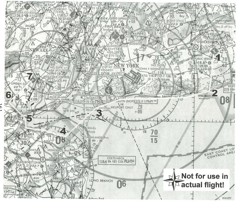
The New York Terminal Area Chart is largely covered with light blue for the water and bright yellow for New York City and surrounding areas. Long Island is part of that area; a long, broad yellow finger pointing eastward from Manhattan. Not until you get out near the eastern tip do you reach areas where the suburban sprawl finally surrenders to the remaining potato farms and other rural land uses, and the yellow ink is replaced with the pale green of low-lying land. Your flight will take you around the busiest, most densely-populated portions of New York City, from Republic Airport on Long Island, to Linden Airport under the shadow of Newark International. And you’ll be able to make the flight without contacting Air Traffic Control.
|
Planning a Route
The section of the chart shows the route for the flight; for a better look at the area, you might want to use the New York Terminal Area Chart which shows more detail. There is a complex of intertwining Class B airspace sections over all three of the major New York airports, making VFR navigation a bit trickier than in most other parts of the country.
The portion of the Class B space that has the most impact on this trip is the section surrounding Kennedy Airport on the south side of Long Island. Some sections have boundaries that follow the coastline, and it is possible to fly just off-shore and remain under the Class B floor. Right next to Kennedy, the floor comes down to 500 feet, which means you will need to get down on the deck at 400 feet (to give yourself a little room at the top) but you’ll have to be sharp about holding your altitude.
Once you get past Kennedy, you can climb to 800 feet and head 240º to cut across the mouth of the Hudson River to Sandy Hook, which is a spit of land that runs north and south. Sandy Hook is also a national recreation area, which means that you are requested to stay at least 2,000 feet above it when flying over it. The Class B airspace floor is only at 1,500 feet just to the east of it, however, so you won’t be able to climb over it. As a result, you can stay just to the west of it.
Once you make landfall at New Jersey, you can follow the coast around to Perth Amboy. There is a swampy area at the west end of Raritan Bay, where you head northwest until you intercept the 45º radial of the Teterboro VOR (TEB 108.40). You can then follow this radial, which will keep you safely to the west of landing and departing traffic at Newark International.
Linden Airport is about 16 nm from the Teterboro VOR, so you can use your DME readout to warn you as you get closer to the airport. You can’t go very far beyond it without busting the Class B airspace around Newark, so be careful. Once you reach the airport, enter a left downwind leg for Runway 27, and you’ll be all set to land.
|
I’ve created a flight log with key checkpoints and headings. One major problem with the flight as planned is that you will spend a lot of time over water at very low altitudes. For the portion along Long Island, you will be able to set down on the beach in case of trouble, but the densely-packed buildings in Jersey would make it a big challenge to find a safe place for an emergency landing. So keep your life vest handy over the water, and think kind thoughts about your engine once you get over the city.
Getting Ready to Fly
You can get ready to fly by choosing the Farmington Republic entry from the World Airports menu under the “USA - New York Addon” list. This will place you in position for takeoff on Runway 1 at Republic.
Republic does have a Control Tower, from which you must get clearance before you depart. You can pretend to make contact with the tower, or you can pretend that you received a clearance by telephone before you left (and are using light gun signals), or you can set your clock back to 6:30 am. The tower doesn’t open until 7:00 am, so you can depart without any clearance at all before that hour.
You’ll also want to tune your NAV1 radio to the Teterboro VOR (108.40), and set the OBS to 45º so you can intercept that radial when you get to the Jersey side.
Other than that, all you have to do is watch your altitude and be careful about staying out of the Class B airspace. Be sure to take a few moments to enjoy the beach and the approach to New York Harbor; at 400 feet, you’re going to get a close-up view!
< Situation file: XC-NYA1
Table of Contents
Previous Section: Section C: New York Add-on
Next Section: I Follow Roads — Linden to Lincoln Park