Cross Country
by Alfred Poor
Caribbean
Flight 1
Keys to the Bahamas
Follow the Florida Keys northeast then cross the Gulf Stream, and you’ll find the Bimini Islands—gateway to the Caribbean. Many pilots use Bimini as their first stop on the way to other islands in the Bahamas, because it is just about a 50-mile hop from the Florida coast, and is a good way to get your feet wet (or keep them dry, as the case may be) for a long over-water crossing.
This flight uses a combination of pilotage and radio navigation procedures, and the most difficult parts of the trip will be having the patience to hold your course and the confidence to trust your navigation when you’re trying to spot a small island in the middle of a large ocean. Just remember that there’s a beautiful beach and a tall, cold rum drink (or other beverage of personal preference) waiting for you at the end of your flight.
|
Planning a Route
This is an international flight, and as a result, there are a number of requirements that I won’t bother simulating here—especially since most of them can be handled on the ground. To make this flight in real life, you’d have to file a flight plan before leaving the United States, and you’d have to have paperwork in order for both Bahamian and US Customs officials. There are also requirements for details such as the size of the numbers on the side of your aircraft, life-saving equipment such as rafts and flotation devices, and other details that you’d have to attend to before departure.
Also, while I have planned all Cross Country flights so that you are not required to communicate with Air Traffic Control facilities, I personally recommend that pilots take advantage of ATC services whenever possible for all flights. This is especially true for a long over-water flight such as this one. If you’re getting traffic advisories from Miami Center as you fly over the ocean, it means that you’ll already be in communication with them in the unlikely event that you encounter mechanical problems. This in turn means that it will take that much less time for help to arrive if you are forced to turn your Cessna into a seaplane.
So keep in mind that this flight and the others in this section are simplified a little more than the flights that remain within the boundaries of the United States.
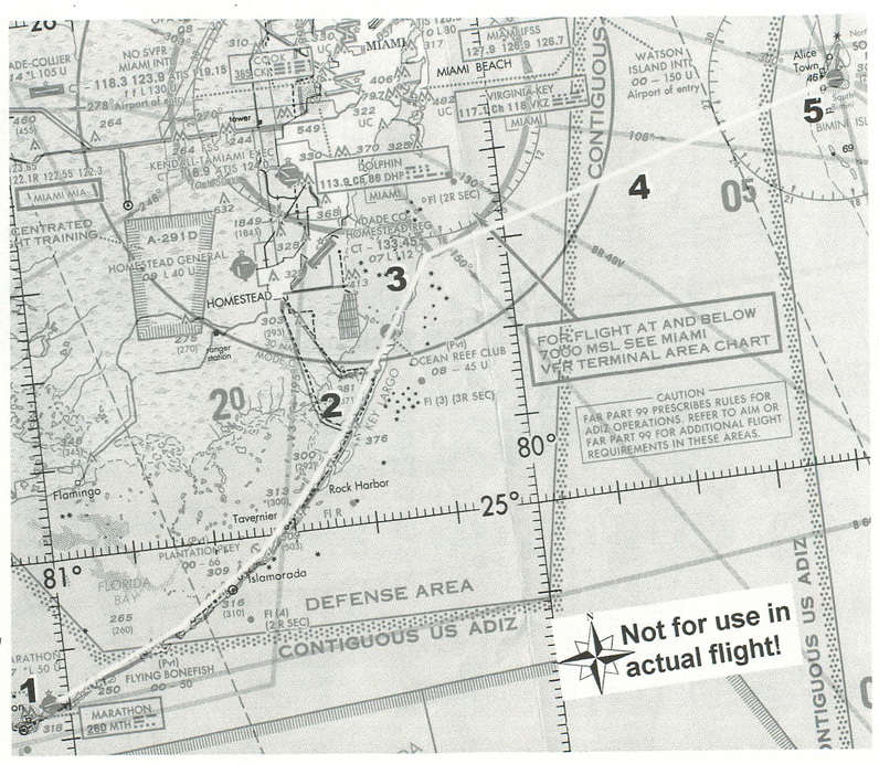
You’ll start your flight from Marathon Airport, halfway down the Florida Keys. You’ll depart Runway 7 straight out, and follow Route 1 as you cruise-climb to your crossing altitude.
The only special use airspace that you need to consider is the Class B airspace that sits over Miami. There’s a piece that juts out over Elliott Key in Biscayne Bay, but it only extends up to 7,000 feet. Since you’ll want plenty of altitude for your crossing, you’ll be higher than that when you leave Florida behind.
|
How high should you fly? The VFR guideline for travel in the eastern half of the compass headings is to fly at odd thousands plus 500 feet. To stay above the Class B airspace, your choices would include 7,500, 9,500, and 11,500 feet. To maximize gliding distance, you’ll want to go as high as practical. There’s another limit to consider at the top, however—and that’s oxygen.
The air gets thinner as you go up, which reduces the amount of pressure of the air in your lungs. This in turn reduces your lungs’ ability to absorb the oxygen and pass it along to your blood; too little oxygen leads to a condition called hypoxia, which can impair your thinking and perception. The FAA regulations require that aircraft crews use supplemental oxygen when the aircraft cabin pressure is at an altitude of 12,500 feet to 14,000 feet for more than 30 minutes. The Aeronautical Information Manual (AIM) is only advice—not regulations—but it recommends that “for optimum performance, pilots are encouraged to use supplemental oxygen above 10,000 feet during the day”. (At night, the effects of reduced oxygen are more pronounced, especially in terms of vision, and the AIM recommends supplemental oxygen for flights above 5,000 feet.)
Based on all the AIM’s advice, I’ve planned your flight for a cruising altitude of 9,500 feet. This strikes a compromise between maximizing gliding distance while minimizing the effects of hypoxia (also you stand a better chance of spotting that island in the ocean).
At a 500 fpm cruise climb as you leave Marathon, you’ll take 19 minutes of climbing to reach this altitude. At 80 knots, you’ll cover 25 nm in this time, which should bring you to Plantation Key—about halfway from Marathon to Key Largo. From there, you can transition to a straight and level cruise at 130 knots.
Remember that the thinner air at this altitude will also affect the performance of your aircraft’s engine. For best performance (and lowest fuel consumption), you’ll want to lean the engine using the mixture control. Don’t forget to enrich the mixture to full rich again before you land at the end of the trip. (For more information on how to use the engine mixture control, see Appendix C.)
Key Largo is the last large island at the northeast end of the Keys, followed by the thin, sandy Old Rhodes Elliott Keys. As you near the end of Elliott Key, you will intercept the 78º radial for the Bimini VOR (ZBV, 116.7). Yes, there’s a VOR right off the end of the airport on South Bimini Island, so you can track your way straight to the field.
When the needle centers for this radial, turn your back on Florida and head out over the water. It’s a 50 mile stretch, which will take just 23 minutes to cross at 130 knots, so you won’t be out of sight of land for very long, if at all. Still, straining to find the island may cause you some anxious moments.
In the real world, you’ll often find clouds building over the Bahama Islands, making it easier to spot them, though it is not uncommon to mistake the shadow under a cloud for land. The water color changes from dark blue to light blue or green around the islands, so watch for these shade changes to help spot land.
You’ll have a lot of altitude to lose as you near Bimini, but you won’t want to descend so fast that you can’t reach land if something goes wrong. As a result, I have planned for you to slow to 80 knots when you’re still 24 nm out, and then start a 500 fpm descent from that point. It will add about seven minutes to your crossing time, but it would work out about the same if you were to spiral down over the island once you got there.
As you approach your destination, you’ll see that there are two islands. The airport is on the southern one, to your right. Fly toward the red and white radio tower on the western shore, and you’ll see the airport directly beyond it. Go ahead and make a straight in approach for Runway 9.
Getting ready to fly
To start, you can use the World Airports menu, and pick the “CBN - USA - Florida” list to find the Marathon Runway 7 option. Then tune your NAV1 radio to the Bimini VOR (116.70) and set the OBS to the 78º radial. At this point, you will be more than 110 nm from the VOR, and you won’t be able to pick up the signal. As you travel up the Keys, the needle will come alive, and you can then verify that you have the correct VOR tuned in (see Appendix C).
You’re ready to rock and roll. It will be a little tricky to see where you’re going as you climb out from Marathon, but you can lower the nose from time to time as you go along to make sure that you’re still on course.
And if you start to wonder whether the Bimini Islands will ever show up on the horizon, just remember that you’ve got a tropical paradise waiting for you at the end of your flight where you’ll be able to relax in the sun.
< Situation file: XC-CA1
Table of Contents
Previous Section: Section D: Caribbean
Next Section: From Paradise to the Stars — Paradise to Stella Maris