Cross Country
by Alfred Poor
Japan
Flight 1
Mt. Fuji Fly-By
One landmark stands out as a unique part of the Japanese landscape: Mt. Fuji. This sacred and beautiful mountain is located on the main island of Honshu, near the southern shore at the middle of the island.
Japan is a country of varied terrain, with rugged mountains, long river valleys, and smooth coastal plains. This flight starts on one of the small islands near Tokyo—Oshima—and takes you past Mt. Fuji and on to Matsumoto in the middle of Honshu. And to make your trip even more beautiful, you’ll get to see a new day dawn as you fly by Mt. Fuji.
Planning a Route
This flight can be completed using nothing more than basic pilotage skills, though you’ll use the VOR beacon at Matsumoto as a backup. Your route is shown on the section of the Operational Navigation Chart (ONC), which provides coverage for areas that are not covered by World Aeronautical Charts (WACs) or sectional charts. ONC charts use the same scale as WAC charts.
|
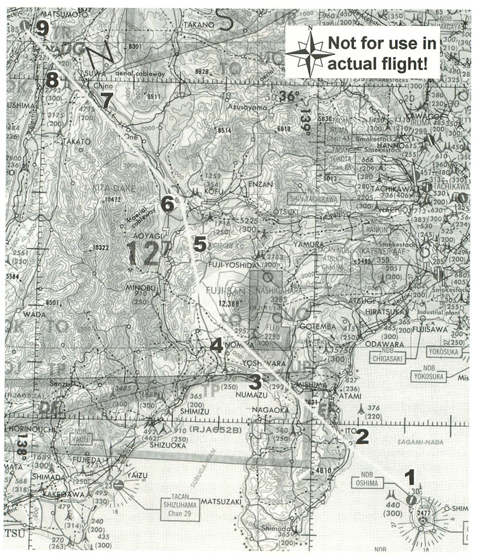
You’ll start from Runway 3 at Oshima Airport, and then turn to the northwest as you climb out. The peak of Mt. Fuji is above 12,000 feet, so it doesn’t make sense to try to climb high enough to fly over the summit. Instead, I’ve planned your cruise altitude at 7,500 feet which is high enough to give you time to find a place to land even when traveling through the mountains, but not so high that you’ll need oxygen. This means that you’ll have about 15 minutes of climbing after take-off, assuming a 500 fpm cruise climb at about 80 knots.
You won’t see Mt. Fuji right away, so just head for the mountainous peninsula and Ito. As you get closer to land, Mt. Fuji will appear; adjust your course (if necessary) so that you are headed to the left of the peak.
As you climb, you’ll be able to see the lights of Fujisawa and Yokohama off your right wingtip, across the bay. You’ll also be able to see Numazu and Yoshiwara at the head of the peninsula once you get past the first mountains.
As you fly over the southern edge of Mt. Fuji, you’ll find a valley headed north, with a road running down the middle. Follow this valley, and you’ll pass a large lake near Kofu. The valley then takes a turn to the left, and you can follow a pair of roads up this valley.
There aren’t many checkpoints along this leg, until you reach Suwa and its large lake. Follow the valley as it bends to the right beyond the lake, and Matsumoto will be waiting about a dozen miles ahead, just beyond the built-up areas and to the left of the two roads that are headed north.
The airport at Matsumoto is at 2,185 feet, so planning on a standard pattern altitude of 1,000 AGL (above ground level), you’ll need to lose about 4,500 feet before you get to the airport. At 500 fpm, that will take nine minutes, and at a 130-knot cruise speed, that means you must start your descent about 20 miles out. So plan on starting your descent about 10 miles before you reach the lake at Suwa. When you arrive at the airport, you can make a straight-in approach to land on Runway 36.
|
A Look at the Log
I have prepared a flight log for your trip. The checkpoints are easy to find, and they are fairly far apart, so you will have plenty of time to enjoy the sights along the way.
Each checkpoint has the distance and estimated time shown, as well as approximate headings. Your actual heading will depend on where you make your turns along the route; follow the instructions and keep track of your position on the chart, and you should make it to your destination without any problems.
As I mentioned at the start of this flight, you will have a radio navigation backup for this flight. There is a VOR at Matsumoto (at least, there is in the FS5.1 add-on scenery), which you can tune in to give yourself an idea of where you are; if you get lost, you can always tune the OBS until the needle centers, then follow that heading to the airport.
The other advantage of tuning in the VOR is that it can tell you when you are 20 miles out—using the DME readout—so that you can judge when to start your descent to Matsumoto.
Preparing to Fly
There is an entry on the World Airports menu for Oshima Airport, and it will place you on Runway 3, ready for take-off. Tune your NAV1 radio to the Matsumoto VOR frequency: 117.60. Don’t be concerned that the OBI dial shows an “OFF” reading; you’re more than 100 miles from the beacon, and you can’t get the signal that far away. The needle and DME readouts will come alive before you reach Mt. Fuji.
The only other setting that you need to make is to use the World Set Time and Season command to pick Dawn for the Time of Day. This will let you enjoy the full majesty of Mt. Fuji as a new day starts.
Enjoy your flight.
< Situation file: XC-JA1
Table of Contents
Previous Section: Section E: Japan
Next Section: Peace Pilgrimage — Okayama to Hiroshimanishi