Cross Country
by Alfred Poor
Japan
Flight 2
Peace Pilgrimage
“Hiroshima.” It is more than the name of a city; it’s a symbol of the horrors of war, known throughout the world. And it’s the home of a shrine dedicated to peace, a monument to those who died and a tangible hope that atomic weapons are never used again.
This trip takes you on a flight from Okayama, along the inland sea around the island of Shikoku, to Hiroshimanishi Airport in Hiroshima.
Planning a Route
The Japanese scenery for FS5.1 is so rich that this is another flight that can be completed entirely using pilotage techniques, relying on visual references. You’ll start from Runway 7 at Okayama, and then turn south to follow the shoreline.
The inland sea area is full of islands; if you’re careful, you can use individual islands as checkpoints along your route, but they form a maze of channels and correctly distinguishing one from another can be difficult. As a result, I have planned your route to take a broader view of the landscape, as shown on the section of the chart.
|
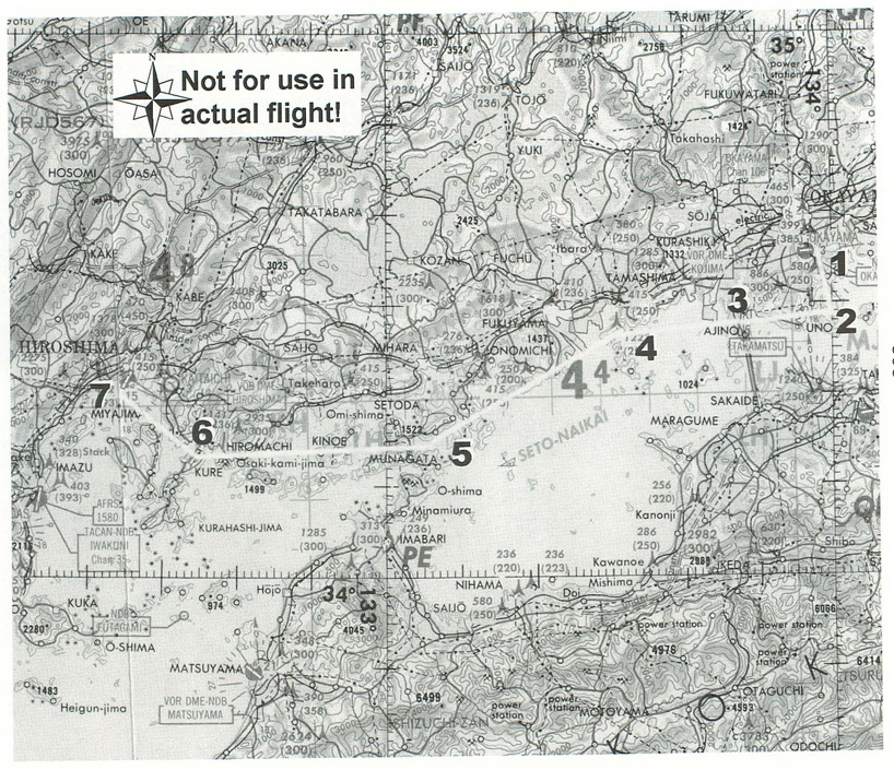
After leaving Okayama, you’ll make the turn to the west at the end of the peninsula near Uno. Shortly after making this turn, you’ll see the impressive bridge joining Ajino on Honshu (the “mainland” of Japan) and Sakaide on Shikoku.
From this point, you’ll simply follow the coastline westward. You’ll next encounter a small clump of islands west of Tamashima—about 15 nm west of the bridge, and then a larger mass of islands around Setoda, about 15 nm beyond that.
Once you’re past this second set of islands, the shoreline turns almost due north at the city of Kure, and that leads you straight to Hiroshima.
Hiroshimanishi Airport can be difficult to spot. It is located toward the western side of the harbor area, and runs almost at right angles to the shoreline. The problem is that there numerous rivers and inlets in the area, and it can be difficult to spot the correct spit of land where the airport is located.
To help you out, there is a VOR on the field (109.85). Dial this into your NAV1 radio, and you’ll be able use the OBI needle to lead you straight to the field.
Since you’ll be close to land the entire flight, and since there is no terrain along the route that poses any particular hazard, I have planned the flight at a low cruising altitude of 2,500 feet, suitable for sight-seeing. This can make it a little more difficult to pick out your checkpoints, but if you get confused, just climb to gain altitude and a better perspective. You’ll need to descend to 1,000 feet to enter the pattern when you reach the airport; plan on entering a left downwind leg for a landing on Runway 4 when you arrive.
I have also created a flight log for this trip, showing your checkpoints along the route. The distances between checkpoints is a bit longer than you might want, but there is little chance of you’re becoming lost when following a shoreline; the biggest danger from the widely-spaced points is that you might become bored or impatient for the next point to arrive.
VFR Flight Log
(1) Navigate using pilotage; all headings are approximate Hiroshimanishi Airport |
Preparing to Fly
Flight preparation is simple for this flight. There is an entry on the World Airports menu under the Japan Add-On for Okayama Airport, which will put you on Runway 7, ready for take-off.
All you need to do is tune your NAV1 radio to 109.85, for the Kanon VOR at Hiroshimanishi Airport. You might want to tune the OBS to a heading of 315º, because that will be the approximate heading to the airport when you round the point at Kure. Having the approximate heading set will make it easier to make a quick adjustment to the OBS if you decide you need the radio’s help in locating the airport.
There’s a lot of beautiful scenery to enjoy along this flight, and for a treat, try flying it at dusk, and watch the cities along your route light up as night falls.
< Situation file: XC-JA2
Table of Contents
Previous Section: Mt. Fuji Fly-By — Oshima to Matsumoto
Next Section: Concrete Compass — Nyutabaru to Kanoya