Cross Country
by Alfred Poor
Japan
Flight 3
Concrete Compass
During the “Golden Age” of aviation in the United States, there were few aeronautical charts, and even fewer navigational aids. Barnstorming pilots would find their way from town to town using whatever they could, including road maps. One of the best navigation aids of all, however, was what the early pilots called “the iron compass”: the steel rails of the railroads that connected many towns throughout the country.
On this flight, you’ll follow a “concrete compass” instead. If you’re good at judging your airspeed and altitude simply by the sound of the engine and the view out the window, you’ll be able to complete this flight without looking at any of your panel gauges. So hit the W key (for the full-screen view) and take off for a scenic flight the old-fashioned way.
Picking a Route
Your flight will take you nearly to the southern tip of Honshu, the main island of Japan. You’ll depart from Nyutabaru Aero, on the eastern shore, and fly down to Kanoya on Kagoshima Bay.
|
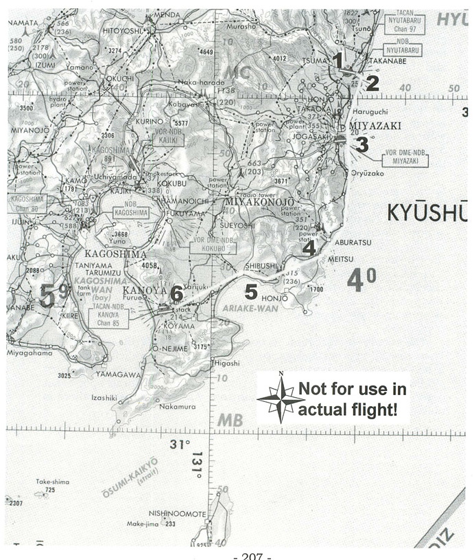
Your sole navigation aid for the trip will be a coastal highway. The section of the ONC chart shows the road and your route. You’ll take off from Runway 28 at Nyutabaru, and then make a left 180º turn to head east toward the coast. You’ll see a pair of roads running north and south; follow the one closest to the ocean.
The road passes through Miyazaki, and then to the west of the airport located just south of the city. One of the safest ways to transit an airport’s airspace is to fly well above pattern altitude, and right across the center of the field; this way, you are least likely to conflict with an aircraft approaching for a landing or climbing out on take-off. So plan to veer a bit to the left so you can cross over the middle of the runway.
The road then skirts a series of mountains that come right down to the water’s edge. It then turns to the west, around Ariake Bay and through the town of Shibushi. Finally, it cuts across the plain separating Kanoya from Airake Bay, and leads you straight to the airport. When you see the airport, assume that the tower has cleared you for a direct approach and landing on Runway 26 Right—this is the shorter of the two runways, but it’s long enough for the Cessna.
I have prepared a flight log for this flight, and it shows all the checkpoints and distances between them. You should also follow along on the chart to keep track of your progress; situational awareness is an important element in navigating solely by ground references.
The remaining question is how high you should fly for this trip. There are no over-water legs, so gliding distance to reach land is not a factor. We’ll assume that you’ll be able to make an emergency landing on the highway if you can’t find any other suitable spot to set down. Also, there is no high terrain that you must cross, so there is no reason to fly high.
VFR Flight Log
1) All headings are approximate; use pilotage for navigation Nyutabaru Aero |
The main factor is being able to see the road in order to follow it. The textures used for the Japan scenery in FS 5.1 are incredibly rich, and it can be difficult to spot the roads and other features if you’re too high. As a result, I have planned this flight for a low 2,500 foot cruising altitude.
Preparing to Fly
There is an entry in the World Airports menu for Nyutabaru Aero that will put you on Runway 28, ready for take off. There’s nothing else that you need to set.
If you want to increase the challenge factor for the flight, dial in some haze. About 10 miles of visibility (use the World Weather Visibility option) will make it difficult to see too far ahead, and will force you to keep a sharp watch for your road so that you stay on course.
< Situation file: XC-JA3
Table of Contents
Previous Section: Peace Pilgrimage — Okayama to Hiroshimanishi
Next Section: Appendix A: Situation Files and the Disk