Microsoft Flight Simulator Handbook
by Jonathan M. Stern
Port Angeles to Everett
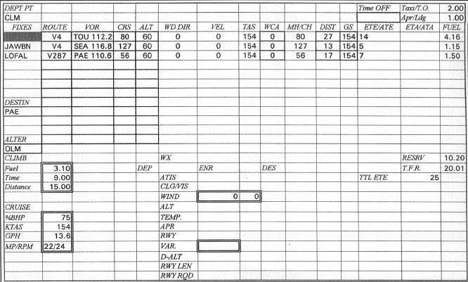
The flight log for the trip from Port Angeles to Everett is already prepared and appears in Figure 17.13.
I selected Olympia, Washington, as the alternate, which was required by the destination weather. The flight planning is predicated on the following weather conditions:
PAE M3 BKN 7 OVC 2 1/2R-F 51/50/3505/012
This indicates that the weather at Everett is a measured ceiling of 300 foot broken, 700 foot overcast, visibility 2 1/2 miles in light rain and fog, temperature 51, dew point 50, surface wind from 350° at 5 knots, and altimeter setting 30.12" Hg. The departure airport has neither a control tower nor a weather observing station and, accordingly, there is no official weather report. I estimate, however, that the weather at Port Angeles is 600 broken, 1,000 overcast, 2 1/2 miles visibility, 52°, surface winds from 350° at 5 knots, and, by setting my altimeter to field elevation, I can determine that the altimeter setting is, in fact, 30.12.
Winds aloft are reported as follows:
| 3,000 | 3013 |
| 6,000 | 9900 +01 |
| 9,000 | 1508 -03 |
| 12,000 | 1613 -09 |
The cloud layers, temperature, wind, and barometric setting should be programmed in accordance with the procedures described in the chapter "Meteorology."
Because Flight Simulator utilizes MSL altitudes to program clouds, the height of the cloud layers (reported in AGL altitudes) must be added to the field elevation. It so happens that the MSL altitude of the clouds reported both at departure and destination are the same. The field elevation at Port Angeles is 287 feet. Added to a 600 foot broken and a 1,000 foot overcast yields layers at 887 feet and 1287 feet.
At Everett, the field elevation of 605 feet is added to 300 feet and 700 feet to yield layers at 905 feet and 1305 feet MSL. Likewise, standard temperature lapse rate explains the slight difference in surface temperatures at the two airports, Accordingly, the weather may be programmed under a global setting to cover both airports.
Having found the highest MEA along the route of flight to be 5,400 feet and the temperature at that altitude forecast to be above freezing, I selected 6,000 feet as a cruising altitude. The 9900 shown for the winds aloft indicates light and variable. Accordingly, winds at 6,000 are programmed as 0.
You are cleared by ATC as follows:
Cessna November 2-0-0-1-Z is cleared to the Everett Airport via V4 LOFAL V287. Climb and maintain 6,000. Departure frequency will be 119.2. Squawk 1-2-7-7.
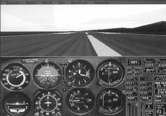
Establish the airplane at the Port Angeles Airport by using the World/Airports menu and selecting from the Seattle scenery area (see Figure 17.14).
Study the route of flight on the flight log and the excerpt of the L-1 LAE chart contained in Appendix B. Set up the cockpit of the Cessna for the trip. Tune the NAV 1 to the Tatoosh VORTAC on frequency 112.2. Victor 4 is formed by the 080 degree radial from Tatoosh, so the OBI should be set to 080°.
The NAV 2 can be set to the Seattle VORTAC, 116.8, and the OBI set to 127°, which is the course to be flown after passing JAWBN intersection. Make sure the altimeter is set to the current barometric setting by pressing B. Set the transponder to 1277. Enable the mixture control and set Prop Advance to Manual in the Sim/Realism and Reliability menu.
Given that you can do little harm with Flight Simulator, I'd like to try something that I saw many years ago in an Al Pacino movie named And Justice For All. In the movie, Jack Warden played a suicidal judge who flew helicopters in Korea and continued to do so in civilian life. One day he finally convinced Pacino's character to fly with him; he explained a bizarre practice in which he regularly engaged. He would calculate exactly how far he could fly and still return before running out of fuel. Then he would fly a little bit beyond that point.
Instead of going beyond what you calculate to be necessary, load the exact amount of fuel that you calculate to be necessary to arrive at the destination. According to my flight planning, you need 9.81 gallons of fuel for taxi, takeoff, climb, cruise, approach, and landing. Use the Sim/Engine and Fuel menu to load five gallons in each tank. You can see how much you have left upon arrival at Paine Field to test the flight planning. Keep in mind that reserve fuel is required in a real airplane:
- Make a normal takeoff from runway 8 and use a cruise climb speed of about 90 KIAS to climb to 6,000 feet.
- When the airplane shows a positive rate of climb and there is insufficient runway remaining on which to land should the engine fail, retract the landing gear.
- Join V4, which is only slightly left of the position on takeoff. When you climb through 3,000 feet MSL, lean the mixture.
- Use normal VOR tracking procedures to follow V4 to JAWBN intersection, which is 73 DME from Tatoosh. Arrival at 73 DME should coincide with the NAV 2 display CDI moving from left to center.
In the Cessna, you should lead the turn onto the route segment between JAWBN and LOFAL by about one-half mile. In other words, at a DME distance of 72.5 miles, begin the right turn to the 127 degree course (see Figure 17.15).
Figure 17.15. By leading the turn onto the new airway at JAWBN intersection, we can roll out on the airway centerline.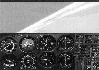
The Seattle VORTAC is used to track V4 Southeast of JAWBN. This is so because the COP is Northwest of JAWBN at 50 DME from Seattle.
- After you are established on V4 Southeastbound, tune the NAV 1 to Paine VOR-DME, frequency 110.6. Rotate the OBI to the inbound course on V287 of 56°. LOFAL is at 29 DME from Seattle.
- When the DME reads 29.5, start a left turn onto V287 and track inbound to Paine.
- When the TO/FROM indicator flips to FROM, press P to pause the simulation, and use the Options/Save Situation menu to save this situation as No Paine, No Gain.
- Exit Flight Simulator or, if you are going immediately to the next subchapter, select the Meigs Takeoff Runway 36 situation from the Options/Situations menu.
Table of Contents
Previous Section: Los Angeles to San Francisco
Next Section: Champaign to Chicago