Microsoft Flight Simulator Handbook
by Jonathan M. Stern
Los Angeles to San Francisco
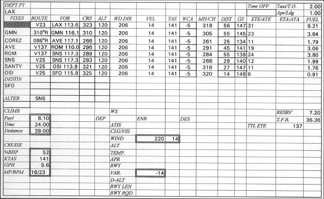
Los Angeles has a published SID that takes you in the general direction of San Francisco. It's called the Gorman One Departure and it has a transition to the Avenal VOR (coded GMN1.AVE). I did all of the flight planning for you; you can have the benefit of my work. I have reprinted the IFR clearance that I received from ATC and the flight log that I prepared appears in Figure 17.7.
You are cleared by ATC as follows:
Cessna November 2-0-0- 1-Z is cleared to the San Francisco International Airport via Gorman One Departure Avenal Transition Avenal V137 Salinas V25. Climb and maintain one two thousand. Departure frequency will be 124.5. Squawk 2-3-7-3.
As an example, set up for a flight from Los Angeles International Airport to San Francisco International Airport. Use the World/Airports menu to select Los Angeles International Airport from the Los Angeles area database.
Both for purposes of programming Flight Simulator and for knowing the weather, the following is the pertinent weather information received from the FSS right before the flight. These elements should be programmed into Flight Simulator before you take off from LAX:
LAX SA 1250 CLR 12 130/60/55/0000/992
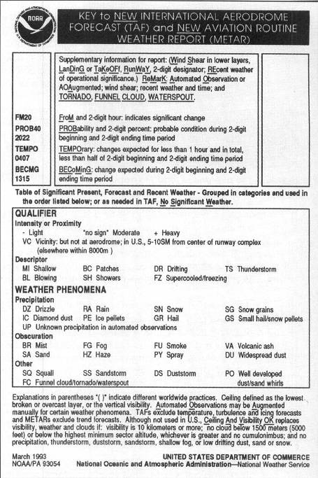
This is the Los Angeles International Airport 1250 UCT surface observation, You can use the Key To Aviation Weather reprinted in Figure 17.8 to decode the report.
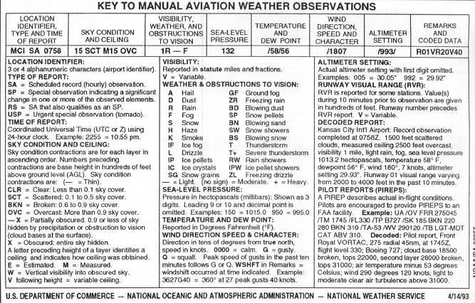
It signifies that the skies are clear; visibility is 12 statute miles; you're not particularly concerned with the sea level pressure in millibars; temperature is 60° Fahrenheit; dew point is 55°; the wind is calm; and the altimeter setting is 29.92.
Of these elements, the sky condition, temperature, wind, and barometric setting should be programmed into Flight Simulator using a global setting.
Winds aloft are forecasted as follows:
| 6000 | 3013+14 |
| 9000 | 2310+10 |
| 12000 | 2214+7 |
The wind direction and speed is coded by omitting the last zero from the direction followed immediately by the velocity. Therefore, 0112 means that the direction from which the wind is forecast to blow is 10°, and the velocity is 12 knots. The numbers following wind direction and velocity for 6,000, 9,000, and 12,000 are temperatures in Centigrade. These winds and temperatures (after converting to Fahrenheit) should also be programmed into the global weather on Flight Simulator.
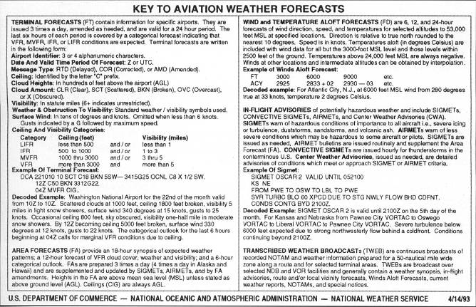
The weather forecasted along the route of flight is generally clear skies and visibility greater than seven miles. The forecast for San Francisco, however, is not as nice, The forecast for San Francisco at the time of the expected arrival is as follows:
SFO FT C9 OVC 3013 OCNL 5 OVC
This forecast indicates that the cloud ceiling is expected to be at 900 feet as an overcast layer, occasionally going down to a 500 foot overcast. The surface wind is expected to be from 300° at 13 knots.
Now you can program as area weather the SFO ceiling and wind by doing the following:
- Select Weather from the World menu.
- Select Add Area.
- Name the new area by typing SFO in area name.
- Type N 037° 51' 18" as beginning latitude.
- Type W 122° 31' 24" as beginning longitude.
- Type N 037° 23' 30" as ending latitude.
- Type W 122° 16' 54" as ending longitude.
- Enter 50 as the width of the area.
- Enter a 10 mile transition.
- Select OK.
- Select SFO from weather area.
- Program specifics of weather using normal procedures.
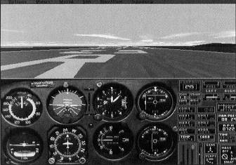
As is normal practice, you should ready the instruments for the flight before you are airborne. Figure 17.10 shows the ready airplane.
Set the NAV 1 to 113.6 and the NAV 2 to 116.1. Set both OBIs to 323°. Study the excerpts of the LAE chart you will use on the flight from LAX to SFO, the L-3 and L-2 charts. They appear in Appendix B.
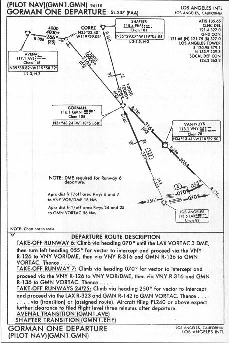
Follow the route of flight, as indicated by the clearance or the flight log, on the chart excerpts. The chart for the Gorman One Departure is depicted in Figure 17.11. It, too, must be studied.
I selected 12,000 feet as a cruising altitude for the flight. If you study the weather, the route of flight, and the Federal Aviation Regulations that address cruising altitudes and oxygen requirements, you will see that you have little or no choice. The MEAs along the route of flight are 9,500, 11,000, 4,000, 6,500, 6,000, 5,000, and 4,500. The courses are all between 180 and 359°, suggesting that the assigned altitude is an even thousand.
If you remain above 12,500 feet for more than 30 minutes, you need supplemental oxygen. From the perspective of avoiding icing, 12,000 feet is likely okay, because the temperature at that altitude is forecast to be seven degrees Centigrade, well above freezing.
Take off from runway 25R and fly a 250° heading while climbing to 12,000 feet. As the air thins in the climb, use a climb speed lower than your normal 90 knot cruise climb speed. By the time you reach 12,000 feet, use a climb speed of about 75 KIAS. Given the nice weather prevailing in the valley, I can instruct you to make a right turn to a heading of 360 when you cross the coastline. Fly heading 360 until you intercept the LAX 323 degree radial, and then track it Northwestbound.
On the Gorman One Departure chart, V23 contains a changeover point (COP) 36 DME from LAX and 20 DME from Gorman. This is the point where you should discontinue navigating from the LAX VORTAC and begin navigating to the Gorman VORTAC. In the absence of a COP, this change should be made where the course changes between NAVAIDS (if it changes) or at the halfway point. If the flight planning is correct and the climb speed is by the book, you should still be in the climb at the COP.
Before you reach Gorman, however, you should be level at 12,000 feet MSL with power set to 16" manifold pressure and 2,300 RPM with the mixture leaned. The Prop Advance control in the Sim/Realism and Reliability menu should be set to Manual to allow full control of engine functions.
You should use the autopilot at your discretion during these trips. For single-pilot operations, the autopilot allows you to perform other tasks without deviating from the course or altitude.
Passage of Gorman is indicated by the TO/FROM flag changing from TO to FROM and the DME indicator increasing rather than decreasing (although, because of slant range, it does not go all the way down to zero). Upon station passage, you need to alter course to the left and track the Gorman 310° radial outbound. On this leg of the flight, the point at which you switch over from navigating from Gorman to navigating to Avenal is, by necessity, at COREZ intersection. This is because the course change is not over a NAVAID.
COREZ can be identified either by 55 DME from Gorman or by interception of the Avenal 86° radial. As you are enroute to Avenal, established inbound on the Avenal 86° radial, you should put away the Gorman One Departure chart and open the L-2 chart.
The remainder of the flight is contained on the L-2 chart. An excerpt is contained in Appendix B.
Depart Avenal on the 296° radial. There is no course change or COP on this leg, so the half-way point, 22.5 DME, is where the switch should be made. When you change to Priest, you should track inbound on the 115° radial (with the OBI set to 295). Because Priest is a VOR, not a VORTAC or VOR-DME, distance information is not available with the DME.
The route segment from Priest to Salinas is 55 miles long and, again, contains no COP. The change to SNS should be made at 27.5 DME. Necessarily, Salinas must be tuned in to one of the NAV radios so that the changeover point is identified. Track to Salinas with the OBI at 287. The leg from Salinas to Woodside along V25 changes course at SANTY intersection. Use normal VOR tracking procedures to arrive at Woodside.
As you approach Woodside, you should run the Descent checklist (contained in Appendix D), because you are going to start your descent shortly.
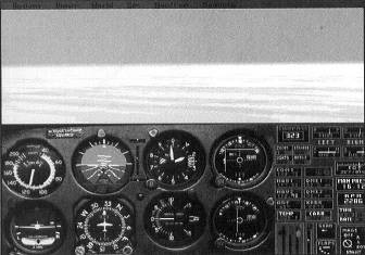
When you arrive over Woodside, press P to pause the simulation. Figure 17.12 shows your arrival over Woodside.
Then save the situation as BayWatch, using the Options/Save Situation menu. Exit Flight Simulator or, if you are going to continue, recall the Meigs Takeoff Runway 36 situation.
Table of Contents
Previous Section: Boston to Windsor Locks
Next Section: Port Angeles to Everett