Runway USA
A pilot's guide to destination cities in Flight Simulator
by Charles Gulick
The Lowdown
In the early days of flying there weren't many airports, so pilots got used to setting their airplanes down wherever there was a stretch of grass, or beach, or any other clearing.
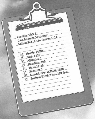
I've set the plane down on this stretch of grass to show you southeastern California's Salton Sea and tell you about its unusual history. But before I begin, let's take off. Don't fly very far upwind. As you can tell from your chart and a study of your location on radar, we're very close to the trailing edge of the Los Angeles sectional, and, for that matter, of Scenery Disk 3 itself. So forget formalities, and as soon as you settle into your 500-FPM climbout, turn left out over the lake and get on a heading of about 315 degrees.
Go ahead when you're ready.
This is a short trip, so we'll fly under the weather. Plan to level off at 1000 feet. Then, when you have reached your desired altitude and you are on heading, tune your NAV to Thermal VOR on 116.2, center the OBI, and fly the needle.
This whole area used to be a desert called Salton Sink, with some depressed sections as low as 280 feet below sea level. Your altimeter read 0 feet on the ground because that's as low as it can read, but you were actually below sea level.
The Colorado River, about 70 miles east of here, flooded its banks in 1905 through 1907, causing 300 square miles of Salton Sink to become a shallow salt lake—now called the Salton Sea. Today's residents in the area don't mind the incursion of the water at all, for they've created beaches and marinas here and prize it as a recreational area.
Over to your right is the Chocolate Mountains Aerial Gunnery Range, so if you see any explosions you'll know what's happening.
About halfway up the western “seashore” is Salton City, and a few miles further is the town of Salton Sea Beach, and above that Desert Shores. On the eastern banks lie the small towns of Niland Marina, Bombay Beach, and, up near the northern tip, North Shore.
The highway that enters the scene as you get closer to Thermal Airport is Interstate 10; it goes to Santa Monica. Your destination airport and the Torres Martinez and Santa Rosa Indian Reservations are all on this side of the highway. Northwest of the airport is the Agua Caliente Reservation.
We'll land on Runway 12. And guess what the field elevation is?
How about below zero for starters?
Table of Contents | Previous Chapter | Next Chapter