Runway USA
A pilot's guide to destination cities in Flight Simulator
by Charles Gulick
Out of the Night
Let's find out what night looks like in the San Francisco Bay area. And from where else but in the air?
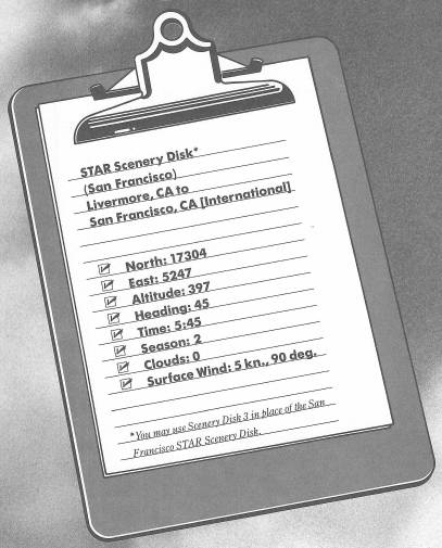
You're looking at the numbers for Runway 7, at Livermore Airport. That white structure on the other side of the airport is—believe it or not—an actual control tower; the building itself is very unusual in the simulator. Even more unusual, for a tower, is that it's permanently empty; you couldn't contact anyone up there if your life depended on it. However, there is an ILS on this field, and you'll hear its middle marker signal as you depart.
Without further ado, let's get up in the air. I want you to get a good idea of nightflying around here. Dawn will break at 6 a.m. sharp, and by then we should be over the San Francisco area.
Take off, climb straight out to 900 feet, then do a 180-degree turn to the left and get on a heading of 260 degrees. Continue your climb to a cruise altitude of 2500 feet.
Take a look back at that beautiful field and the tower as you climb out.
Once you're on your heading, the highway you're paralleling is Interstate 580. It goes the way you're going to San Leandro, then turns north through Oakland, and eventually crosses the water into the city of San Rafael, forming the Richmond-San Rafael Bridge. The bridge divides the water into two bays, San Francisco Bay to the south and San Pablo Bay to the north.
Just below you, on this side of Interstate 680, is a U.S. Army Reserve Center.
Tune your NAV to Oakland VORTAC, 116.8, crank the OBS around to center the needle, and take up the indicated heading. The radial I'm turning for is 254 degrees.
When your DME reads about 5 NM from the Oakland station, change your NAV frequency to 116.2, reset your OBS, and get on an inbound radial for the Sausalito OMNI. I'm doing this so that we can see the Golden Gate Bridge at night. Oakland International will show some of its blue-lit taxiways as you start your turn toward Sausalito. The radial I'm turning to is 278 degrees.
Hold your altitude within 100 feet of 2500. Your instrument scan should remind you of this regularly—and that's another reason why you should scan regularly. In today's busy skies, the ability to manage altitude is mandatory, and you should be conscious of it all the time.
The first bridge that comes up on the horizon is the San Francisco-Oakland Bay Bridge. After a disk access, you'll get a riot of color out your windshield—Nimitz Field right off your nose, the Bay Bridge on your right, San Francisco in the distance, and the Golden Gate Bridge beyond it. I hope you're seeing this at night; and if you got off from Livermore promptly you should be, though with only seconds to spare. My clock reads 5:59:50.
Tell you what. If dawn has come already for you, you can go into the Editor and change just the time, to 5:58. That way, when you exit, you'll get the night view.
And be ready for the dawn, which turns on at 6 a.m. And that's another grabber, isn't it? Much of San Francisco is just beginning to stir at this hour, but the crab fishers of Fisherman's Wharf started their day about four hours ago, in hundreds of little one-man boats. By now they're 15 miles out on the ocean you see lying there so mutely, beyond the Golden Gate Bridge. Ernie Pyle, the great newsman, describes their 14-hour day memorably in his book, Home Country.
When you can no longer see Alcatraz beneath your nose, reduce your power a couple of notches and start a 500-FPM descent to 1000 feet.
When you can no longer see the north end of Golden Gate Bridge, make a standard-rate turn to the left, to a heading of 190 degrees. You'll get a panoramic view of the bridge as you turn and then a great view of the western shore of San Francisco at dawn.
Furthermore, you'll be on an extended base leg for a landing on Runway 10R at San Francisco International Airport. Retune your NAV to San Francisco VOR, 115.8, so you can check your distance on the DME. You're probably 10 to 12 miles away from the airport.
Your best checkpoint here is San Bruno Mountain, because the airport is south of it. You'll see the mountain over to your left. But also observe it carefully on radar. When you're past the near corner of the rectangle symbolizing the mountain, and about opposite the southern tip of the small body of water (Lake Merced) which appears on the display, you should be able to spot the near end of the parallel east/west runways at San Francisco International.
You'll see that you should turn final just a short distance beyond the southern edge of San Bruno Mountain. It'll be a long final—an airline approach—perfectly acceptable at a major airport like this. In fact, you may want to try a slightly different kind of landing here.
Don't transition to slowflight and don't use any flaps. Put on carb heat, and make a long, flat approach like the airlines fly. Try to judge your approach to descend right to the threshold at a VSI rate of about 200 to 250 FPM, and at or near your cruising speed. Make your flare gently and cut your power just before you touch down. You have over two miles of runway, so with a little care you should come in fine, and you'll have a new experience as well as a new skill in your repertoire. Further, the tower will appreciate how you expedited your landing. A KIAS of 70-odd knots is not a favorite pastime at big airports like this.
If you miss the airport entirely, don't be dismayed. You won't be the first. The disk access changes the perspective of things, and it's easy to get disoriented. Just add power, go around, and try the approach again.
Table of Contents | Previous Chapter | Next Chapter