IFR Flights of 13MIKE
by Fred J. Calfior and Douglas W. Miller
| Flight Scenario One |

Islip to Westchester County |
(New York Area - estimated flying time 60 minutes)
Well, here we go again! Hi, Professor Miller here! Let's jump right into the first IFR flight and get our feet wet. This flight departs Islip which is on Long Island, New York and arrives at Westchester County which is northwest of Islip across the Long Island Sound. First we will trace our route of flight, fill out the flight plan, and play 20 questions or something like that! Afterwards, Professor Calfior will help you with a rather extensive weather brief, followed by my skillful guidance through the initial setup. By this time you will be ready for Professor Calfior to assist you with the Preflight, Taxi, Runup, Departure, Cruise, Descent, and Approach to your destination airport. Remember to listen to Professor Calfior, he is trying to help you obtain the best possible score.
Let's look at our route of flight for this scenario. It has some interesting instrument procedures and an unusual approach.
FLIGHT PLAN -
This route of flight follows well established departure, climb, cruise, descent, and landing procedures. You will depart Islip, Long Island MacArthur Airport (Airport diagram and Takeoff Minimums in Appendix C1) on runway 6 at 1430 Zulu. With radar vector assistance from New York Departure Control, you will track inbound to Calverton VOR. Cruise altitude will be 5000 feet with a computed true airspeed of 130 knots.
From Calverton, you will slip into the BOUNO TWO ARRIVAL (STAR diagram in Appendix C1), which is a Standard Terminal Arrival Route, or STAR, into White Plains, Westchester County Airport, New York. You will be in contact with Boston Center as you fly the Calverton 002 radial through ZAHNN intersection, turning inbound on Bridgeport's 104 radial at EILEN intersection. Track inbound to Bridgeport until station passage, and then proceed outbound on the Bridgeport 288 radial. You'll go through ALIXX intersection until arriving at RYMES intersection. The weather seems to look good over Westchester County, so you will request a vectored descent from New York Approach Control, and when you see the field, you will cancel your IFR clearance. With a fuel on board of 6 hours, and enroute time of 55 minutes, that's plenty of fuel for an alternate plus 45 minutes FAA minimum. Danbury Municipal is a good alternate airport.
Looking at your airport diagram for Westchester County Airport (Appendix C1), you will come in visually for landing either on a left 45 degree traffic pattern entry or a left base to runway 16, depending on Westchester County Tower's instructions. Keep in mind it is a Class D airspace, so you can't come within 5 nautical miles of it until you have established radio communications and been cleared to continue inbound.
FILLING OUT THE FLIGHT PLAN -
Fill out the following Flight Plan completely, carefully paying attention to your route of flight. Trace out your route using the IFR low altitude enroute chart L-28 given to you in Appendix B1.
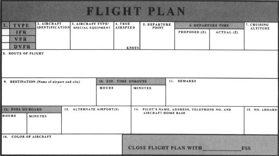
Now answer these questions from your flight plan and enroute chart.
** a) What is in block 8, Route of Flight, of your flight plan?
_______________________________________________(10 pts)
** b) The leg from Bridgeport to RYMES intersection crosses what Victor Airway?
_______________________________________________(10 pts)
** c) From Long Island MacArthur to Calverton, what NDB do you pass to the right of you?
_______________________________________________(10 pts)
** d) What is the minimum reception altitude at RYMES intersection?
_______________________________________________(10 pts)
** e) List the Victor airways that RYMES intersection is on.
________________________________________________(10pts)
"If you make believe that the Long Island Sound is the Atlantic Ocean, and Westchester County is Paris, France, then this will become a fun intensive transatlantic IFR cross country flight! Before we get too deep into the nuts and bolts of this specific jaunt, I want to brief you on proper Flight Service Station etiquette when calling them, and what they expect to hear from you. You are expected to supply them with a certain amount of background data, so that they can input it into their computers in a logical and no nonsense fashion. I'll write the desired sequence of information in order for you on this white board, and you will, after our eight flights together, be able to verbalize it in your sleep! Here we go!"
1. Type of flight (whether IFR or VFR)
2. Aircraft ID
3. Type of aircraft
4. Departure airport
5. Proposed time of departure
6. Desired cruise altitude
7. Route of flight
8. Destination
9. Estimated time enroute
10. Remarks
"What I want you to do is go and visit Islip Flight Service Station right here, and enjoy the luxury of a face to face briefing. Practice this background data that I've shown you, and get yourself a weather brief and file our flight plan that we discussed a little while ago. Hup, two, three, four, what are you waiting for? We 've got an ocean to cross!"
Table of Contents
Previous Section: The Instrument Environment
Next Section: Flight Scenario One: Weather Brief