40 More Great Flight Simulator Adventures
by Charles Gulick
Sentimental
Journey
Journey
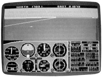
| North Position: 17031 | Rudder: 32767 |
| East Position: 21073 | Ailerons: 32767 |
| Altitude: 12 | Flaps: 0 |
| Pitch: 0 | Airspeed: 0 |
| Bank: 0 | Elevators: 32767 |
| Heading: 315 | Time: 18:00 |
| Airspeed: 0 | Season: 3-Summer |
| Throttle: 0 | Wind: 4 Kts, 275 |
Important: Change Slew to 1 for this mode. |
|
| Follow me on this strange little
trip, and you may learn a couple of
things. Such as how to use slew if you haven't tried it. And mostly,
how to put yourself in a place that's important to you personally, if
there's any such place in the simulator world. For example, how to put
yourself and your airplane in your own garage or backyard. Or how to
create an airstrip that's significant in your experience, but maybe
wasn't significant enough to make it into the simulator. After we get where we're going this summer evening, I'll tell you why we went there. Or anyway, why I went there. I'm writing this in the act of going. In other words, I first do what I'm instructing you to do, then I write it, bit by bit. So we discover together how it all works. The parameters we've set up put us at JFK, at the tie-down we created in an earlier adventure, but with a very small difference in heading. These will not be our final parameters. They're just a place to start. For this sort of operation we need a place to start. When you exit the editor, you'll hear the engine stop and you'll see the north and east coordinates at the top of the screen. Your heading may or may not be 315. But that's the heading we want exactly. |
|
 |
Open your manual to the page
which illustrates slew controls, and if
your heading isn't 315, use the Heading Slew keys to get on that
heading. Next, press the altitude Up slew key once (on the PC there's no up label, but it's the F2 key), and look at your altimeter. You'll be gaining altitude at 50 to 100 feet a second. (With the Piper you'll need some more presses to get up to speed.) Poise your finger over the Freeze or Slew Freeze key, and press it when you show about 5000 feet of altitude. No need to be exact. At this point you'll see a bit of La Guardia Airport off to your right. The highway is Interstate 495. It points to and goes through the QueensMidtown Tunnel. That tunnel to Manhattan and then the Lincoln Tunnel to New Jersey are straight ahead. The blue you see is, on the near side, the East River, and on the far side, the Hudson River. |
|
Now tune your NAV to Kennedy
VORTAC, 115.9. Your DME will indicate that
you're about a mile from the OMNI station. To be as precise as
possible, we'd like to be right over the OMNI station. Because where
we're going is exactly 28 miles from there and on a heading of 315. We're a little north and a little east of the OMNI dead center, so let's first slew a little south. Press the South key several times and watch the DME reading. Also keep an eye on the OBI, which will read FROM for a bit, and then at about 0.6 nautical miles will change to TO. Freeze the slew when you have that reading. Now press the West key a number of times, and shortly you'll get an additional countdown. Poise a finger over the Freeze key, and press it when the DME reads 00.0. How's that for precision? If it didn't work exactly for you, use your Recall key and try again. You'll quickly nail it down. Now we're at 5000 feet over the Kennedy VORTAC and on the 315 radial. Next we want to slew ahead exactly 28 miles. Not north, south, east, or west, but ahead. To do this if you're flying Cessna, enter the editor and change the slew parameter to 2. Then exit. If your version of the simulator doesn't have the ahead feature, just read along until the next instruction to enter the editor, then change the parameters to those given at that point. Pressing the North key will propel us forward on the 315 radial. You can press the key numerous times to slew faster and faster, or you can take it easy and see the lower end of Manhattan pass under you. You'll pass directly over Manhattan Bridge and the World Trade Center towers, with the Statue of Liberty over there to your left, and then across the Hudson to Weehawken. Watch your DME as you build up distance, and ready your finger to freeze the slewing when the DME reads 28.0 nautical miles. You can slow up, remember, by pressing the South key. Do that as you near 28 to avoid whizzing right past it. But even if you passed it, simply slew south to get back. You can even slew back a tenth of a mile. Now we're exactly over our destination, but at 5000 feet. So press the altitude Down slew key (unlabeled in the PC illustration, but it's the F10 key). You'll lose those 5000 feet in a big hurry, but you won't crash. |
|
One more thing we want to do
here on the ground is change heading to
280 degrees, the reason for which will soon be apparent. To do this,
use the left Heading Slew key, and freeze it at 280. Again, you can use
the opposite key if you go past. Now exit to the editor and you'll see the parameters of your present location. Follow down the list with me and change just what's indicated: • Change slew to 0 • Change flaps to 0 • Change heading to 280 • On page 2, change minutes to 0 Save the mode as it now exists. The only differences are the north and east parameters and the altitude. These are now on or very close to North, 17104; East, 20881; Altitude, 410 (if you had no Ahead slew, enter these values). |
|
Exit the editor. Be advised: You're sitting on a piece of geography of the greatest interest to this writer. But of interest to you, too, because getting here taught you how to get to any specific place, a place that matters to you. It could be, as suggested earlier, virtually your own front yard. Or a farm where you spent time as a youngster. Any spot, so long as the simulator encompasses it, which is meaningful to you personally. To determine where I wanted us to get to in this slew operation, I used a combination of tools-a map of the metropolitan New York area, showing the key routes and roads; a copy of the FAA New York sectional chart; a ruler to pinpoint what radial from Kennedy would cross the location I wanted to reach; and the same ruler to determine the nautical mileage from Kennedy VORTAC to this place. Just what is this place? It's a place where a runway used to be, but is no more. You're positioned backward in time about 20 years so that you're sitting at the threshold of runway 28 at Totowa/Wayne Airport, Totowa, New Jersey, ready for takeoff. You may see only green and blue out there. I see a lovely, lonely runway in the grass, with a sunset at the end of it. And hear and feel the engine of a rented Cessna 150 out in front of me. And I run her up to 2200 rpm. I feel the flap handle in my fist as I watch the flaps come down: 10, 20, 30, 40, and back to 0. Between my thumb and forefinger I can feel the magneto switch, and then the knob of the carb heat, and see the rpm drop when the heat comes on. Everything checks out fine. My instructor, Arnold Kufta, has just told me, "You've been safe a long time. Tonight, you're precise." He got out of the airplane a few minutes ago, back there on the tarmac in front of the office. I'm alone in this airplane. The first time that right seat's been empty. "Remember, you'll be a bit lighter without me in there. You'll climb faster." I'll save this mode for myself, just the way we've created it. I know how to fly from here to Danbury or Westchester or Republic, or a dozen other places in the simulator, in the world it recognizes. Even though my takeoff is from somewhere it doesn't recognize. As for you, why not use this technique to create a Totowa/Wayne of your own? And let that be this mode rather than the mode set up at the start of this adventure. So you're off a few tenths of a mile in your calculations. Who'll ever know? As for the geography you're looking at, today there are houses sitting there. And no hint of the runway I remember. But the grass-the green-in this simulator scene has some real justification. As students, we used to land on the grass instead of the runway. Easier on the tires, the airport operator said. And easier on the runway, too. So I'll take off from the grass. And, as Arnold used to say, see the sun rise in the west. |
Table of Contents | Previous Section | Next Section