40 More Great Flight Simulator Adventures
by Charles Gulick
Headin'
Uptown
The Manhattan Project III
Uptown
The Manhattan Project III
| North Position: 17065 | Rudder: 32767 |
| East Position: 20996 | Ailerons: 32767 |
| Altitude: 23 | Flaps: 0 |
| Pitch: 0 | Elevators: 32767 |
| Bank: 0 | Time: 15:00 |
| Heading: 41 | Season: 4-Fall |
| Airspeed: 0 | Cloud Layer 1: 9000,6000 |
| Throttle: 0 | Wind: 3 Kts, 35 |
| Here's an optimum position for
takeoff in the uptown direction from your grass strip on the East River. By the way, this is as good a time as any to explain something about the elevation here. You may have an altimeter reading that's far from 23 feet. This is a simulator peculiarity-sometimes it doesn't get its altitudes correct, particularly when on the ground and not on familiar turf. Obviously, the simulator doesn't know you've turned this little green spot into an airport. Your altimeter may read in the 100's, 200's, even 500's, or more. But there's no question that you're on the ground. If you weren't, you'd fall from the sky. Obviously. Don't worry about such elevation discrepancies. Once you land somewhere else and then fly back here, this grass will settle down to its true altitude so that when you land it'll be where it's supposed to be. Probably. I say probably because I can't be sure that's always the case. I've tried various tricks to make the altitude read right, but the only thing that seems to work-and that only sometimes-is landing elsewhere and returning. If you discover a better method, let me know. (Usually, once the simulator establishes that your strip is at 20 to 23 feet elevation, it remembers that as long as you fly in the area.) |
|
 |
Let's find out what it's like to
take off in this direction. Go ahead,
but pause once you dump your flaps and admire the view ahead. How sweet
it is! Every bit as interesting, graphically, as a takeoff to the
south. The East River stretching ahead to your right and curving off
where it passes La Guardia. Queensboro Bridge crossing your windscreen,
connecting Queens and 60th Street. FDR Drive (which becomes East River
Drive north of the Queensboro Bridge), just one of a number of
perspective lines meeting at the horizon. The overcast this afternoon
only adds to the scene. The money I put into this great site was well
spent. And you're worth every penny of it. Unpause and continue climbing straight ahead, trimming for 500 fpm at 2105 to 2050 rpm as usual. As you reach about 1000 feet, you can see the Hudson on the other side of New York. Out to the left, Central Park. That mesh of lines to the far right is the Bronx-Whitestone/Throgs Neck bridges complex with its connecting highways. And out the right side, you see the bridges where they are, just beyond La Guardia. |
 |
Plan to get straight and level,
and in slow flight, at 2000 feet. When
East River Drive disappears under your nose, turn left to a heading of
310. Then pause and look out the left side at a fine vista of
Manhattan. Queensboro Bridge, again, is nearest you. The bridges
crossing the bottom of the East River are the other key group of
bridges. If you look closely, you can probably make out the spot where
Manhattan juts over to meet the river, just this side of the
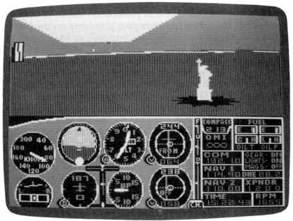
Williamsburg Bridge. Right there at Edge Road. Fly on, turning left to track down the Hudson River with the Statue of Liberty a bit to the left of your nose. Any heading that accomplishes this is fine. Reduce your power to descend to 1000 feet for a close-up flyby of Liberty. If you aim at that portion of the New Jersey shoreline just about opposite the statue, you should be able to get fine views out the left side as you go by. You'll be just about over the New Jersey coast. When Liberty is off to your left you may want to go into a bank for the best view. You're going to turn and head 130 degrees here, so you'll have seen the landmark from several sides. |
|
Heading 130, continue to keep a
lookout to your left, and prepare to
turn and shoot your first landing to the north. Use radar if desired to
help you get your bearings and get lined up. Don't forget carb heat and your flaps. This time and always, land as close to this end of your airport as possible, so long as you're beyond the pavement area of the city. Remember that your airport lies this side of where the pavement juts out toward the river. Also, the closer you are to the river, the more grass you have, and the more likely you are to come to a stop this side of Edge Drive, which wins you a ribbon and the gratitude of the neighborhood. Finally, remember that your best guide to elevation here is your eyesight. You're down when your wheels say you're down, whatever your altimeter reads. When you're down, you're 20 to 23 feet above sea level, depending on exactly what part of the real estate you're on. If you have any doubts, look out the window. |
Table of Contents | Previous Section | Next Section