40 More Great Flight Simulator Adventures
by Charles Gulick
Reverse
English
The Manhattan Project II
English
The Manhattan Project II
| North Position: 17577 | Rudder: 32767 |
| East Position: 21524 | Ailerons: 32767 |
| Altitude: 246 | Flaps: 0 |
| Pitch: 0 | Elevators: 32767 |
| Bank: 0 | Time: 5:00 |
| Heading: 240 | Season: 3-Summer |
| Airspeed: 0 | Wind: 3 Kts, 230 |
| Throttle: 0 |
| Dawn at the Windham Airport,
Willimantic, Connecticut, finds you on the
threshold of runway 24 (6/24 is only one of three strips here). You
want an early start because you've more than a hundred miles to fly.
You know your destination. As promised, you're headed for your first
official landing at your airport in downtown Manhattan. (If you haven't
already named it, that's a name for you: Manhattan Airport.) Some
friends are meeting you there for a celebration breakfast. Now, there are many ways you could fly from Willimantic to New York City. Just find Windham on your chart, unless you're flying Cessna, in which case your chart doesn't favor you with any but a handful of major airports. For you, be advised Windham Airport is roughly 18 nautical miles northeast of Hartford OMNI. Anyway, look at all those OMNI stations on your chart. You could map out an OMNI route easy as pie. Or three or four of them. But this morning I'll be navigator. And I'll show you, using a single OMNI radial, not only how to fly to Manhattan, but how to fly absolutely positively straight to your new airport, as if on a homing beacon all the way. And when we get there, I'll tell you how I worked it out, and how you can do the same for any special flight you want to make in the simulator world. |
|
 |
Prior to
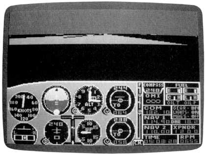
departure, tune your NAV to Hartford, 114.9, and center
the OBI needle with a TO reading. The OBI will show that you're sitting
on the 262-degree radial from the Hartford VOR station. But set your
OBI to 244 degrees. It'll still read TO, and your DME will show a
distance of about 18 miles. Since we want to fly across the "spokes" of
the OMNI station-say, 10-15 degrees south of the hub, until the OBI
tells us we're on the right radial-to intercept radial 244, we'll take
off and turn right to a heading of 250. We'll fly that heading until we
intercept 244, then track that radial all the way to the strip on the
East River. (If we flew right over the hub, it wouldn't help much,
since all the radials come together there.) |
 |
Assuming you've readied the
aircraft, go ahead and take off. Turn to
head across the radials after you have 700 feet of altitude. With a power setting of 2105 rpm in the Cessna, or 2050 in the Piper, trim to climb at 500 fpm to a cruise altitude of 4500 feet. We choose this altitude because, above 3000 feet, the formal altitude for aircraft heading between 0 and 179 degrees should be an odd number plus 500 (3500, 5500, 7500, and so on). For headings from 180 to 359, it's an even number plus 500, such as 4500 and 6500. In a general sense, these headings may be thought of as eastward and westward respectively. I've written a short poem to make these regulations unforgettable and dispel any possible confusion once and for all: When fly you would a heading west, Odds are you'll evens find are best, Plus 500. Nice lilt to it. You might want to get it lettered in Olde English style on parchment by a calligrapher and have it framed for your wall. I'd be honored. |
|
Although you're heading 250
degrees, your OBI is set for the 244
radial. To have some fun, set NAV 2-not 1-to tune the same Hartford
VOR, 114.9, and set OBI 2 to center the needle. The OBI 2 reading will
tell you what radial you're crossing at the moment. If you keep
centering that needle, you'll have a steady check of the radial you're
on and will be able to "see" 244 coming up. Note that each dot on the
OBI scale corresponds to 2 degrees. Don't be thrown by the fact that the radial numbers increase. You'll see that they increase faster and faster as we get closer and closer. So you'll keep pressing the key more and more often to keep the needle centered. Eventually, you'll pass zero and beyond. When you're approximately four miles from Hartford OMNI, your OBI 1 needle will switch from off scale to center, and the indicator will read OFF. Soon after that it'll read FROM, and the needle will go off scale to the right once more, indicating the 244 FROM radial is still to your right. The rate at which your OBI 2 needle, pointing to the station, changes indicates how close you are to that station, where the radials get closer and closer together. Note that OBI 2 still shows a TO indication. It'll continue to do that, indicating on what radial we are from moment to moment, as long as we keep the needle centered. The OBI 2 reciprocal heading, at the bottom of the instrument, steadily indicates the "from" radial. So as we get closer and closer to 244, that's indicated by the reciprocal reading. When, for examplewith the OBI 2 needle centered-the OBI reciprocal reads 216, we're crossing the 216 FROM radial, when it reads 230, the 230 radial, and so on. As we fly away from the station, the OBI 2 needle activity slows up correspondingly. Keep the needle on scale and center it frequently. |
|
When your DME reads about 13.5
nautical miles from Hartford OMNI, note
that the needle on your primary OBI creeps on scale from the right.
Note, too, that the secondary OBI, when its needle is centered,
confirms that you're about ten degrees from your target, the 244 radial. As you get closer to 244, it seems like an eternity between each two-degree change of the OBI. This is because you're only six degrees off the actual radial heading, so you're roughly paralleling it. Using the spoke-and-hub analogy, you're aiming at only a slight angle toward the two hundred forty-fourth spoke. You'll thus be quite far out on its span before you actually intercept it. We could easily correct for this by turning at a sharper angle inward in relation to the radial, thus hastening the meeting. But for the demonstration purposes of this flight, just hang in there at your 250 heading. You're flying in the direction you want to go anyway, within a few degrees. And somewhere along the way, the sun comes up, too. If you were approaching the 244 radial at a considerable angle, it would be a good idea to anticipate it, say, about two degrees before you get there. But since you're entering almost parallel to it, wait until your primary OBI needle is centered and then make a shallow turn to the left, subtracting just six degrees from your heading. Notice now that your two OBIs agree. The primary OBI says you're on the 244 radial FROM Hartford to Manhattan. OBI 2 says that same radial TO Hartford is on the reciprocal heading, 64 degrees. So what's that water out there, the Hudson River? Is this another trick? If it's the Hudson, it looks like we're flying up it. But your instrument panel tells you otherwise. You're on a southwesterly course, 244 degrees, a . an altitude of 4500 feet. |
|
Go into radar and take a high
altitude view, one that shows you an
airport this side of the water. That airport look familiar? Now go a
notch or three higher and everything jives. At your altitude you can
see across the Sound to Long Island, and the Atlantic beyond it. Out
the windshield you can see almost to Manhattan. The Hudson River is
visible as a pencil line to the right front. Your airport on the East River is exactly 84 nautical miles from the Hartford OMNI station (if you're flying with an Apple simulator, it's 88.1 nautical miles). I'll explain how I know that (and it wasn't by making the flight we're making now) a bit later on. |
 |
Your heading is taking you right
along the north shore of Long Island Sound-a nice picturesque route. Should be able to raise the JFK tower somewhere along here, on 119.1. Do it. And note something interesting. Kennedy is landing on 22. Of course. Kennedy's 4/22 runways (there are two of them, left and right) agree with the landing/takeoff headings or "runways" of your airport. So anytime you don't know the weather or wind, you can check Kennedy. If they're using 4 or 22, you follow suit. If not, you can land/takeoff whichever way gives you the most favorable oncoming wind. Soon La Guardia comes into view. You can even begin to see where the East River, rolling past the airport, swings south toward Upper Bay. Sure enough, you're in there somewhere. You have about 4000 feet of altitude to lose between here and your airport. Our formula for start-descent distance tells us we'll want to begin our letdown about 16 nautical miles from your field. We can use that formula's information going from a VOR station as well as to it if we know how far our destination is from the station. Since 84 minus 16 equals 68, start a 500 fpm descent when your DME reads 68. But at 1000 feet, hold that altitude and establish pattern airspeed. We won't land immediately. (Again, since the Apple version distance is a bit more-88.1 to be exactyou need to start your descent at about 72 miles from Hartford.) Our course takes us just about dead center over La Guardia's 4/22 and 13/31 runways. And you'll find we're just a little to the left of your airport, for reasons I'll explain once we're on the ground. But we're pretty precise nonetheless, after a flight of more than a hundred miles in a virtual straight line. Watch your field go by out the right side. |
|
After radar shows you're past
Manhattan Bridge, fly a big circle to the
left and get downwind for a landing on runway 22 nominal, your airport.
Try turning base opposite the Empire State Building. Your friends are all watching, so make it a good one. You'll be rewarded with a celebration breakfast. If it looks like you'll mess up, go around (in which event wag your wings so you can tell them you just wanted to overfly the site as part of the celebration). |
|
After you've celebrated, access
the mode where you saved Adventure 25,
"Splendor in the Grass," and I'll show you how I decided on the heading
to take from Hartford OMNI, and the distance, if you haven't already
figured it out. When you exit the editor (double-check that your heading is 220), look at your DME. If you haven't detuned Hartford, you'll see that it reads 84, within a tenth or so (a bit over 88 on the Apple). So you can check the distance from an OMNI just as you check it to an OMNI, to or from anywhere in range. Now look at the OBI. If the radial we flew244-is still there, you'll see that the needle is approximately centered. Approximately, but not precisely. Reset it to one radial higher, and note that it goes off-center the same distance in the opposite direction. This is because the OBI reads in increments of two degrees. So the exact radial your airport is on in respect to Hartford is between 244 and 246. Or 245. We flew 244 for our demo purposes, which at this distance from Hartford represents the geographical distance you observed from the air, in other words, the amount of geography you were to the left of where you are right now. We could have flown the 245 radial, if there were such a thing, by flying with the needle held a little left of center. We'd have been closer to overflying your airport. But even then, that 245 could represent several hundreds of feet. Anyway, you get the idea. |
Table of Contents | Previous Section | Next Section