Cross Country
by Alfred Poor
Hawaii
Flight 1
A Spin Around Niihau
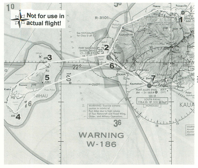
Kauai Island anchors the northwest end of the Hawaiian archipelago, with little Niihau dangling off its western tip. There are four airfields on the island, but only two without control towers. And one of those two is a private field.
For your first flight in Hawaii, I have planned a simple sight-seeing jaunt around this left-end of the island chain. You’ll start at the private Princeville airport on the north shore of Kauai (we’ll assume that you have permission from the owners to be there), and you’ll fly around the island of Niihau, and on around to Port Allen on the south shore of the Kauai.
Planning a Route
There are not many radio navigation aids on the island, but it’s easy enough to use standard pilotage techniques in this feature-rich environment—there’s something identifiable just about everywhere you look.
|
I’ve planned the flight for calm conditions, but that is not all that realistic—trade winds often blow 20 knots or more. You can dial in some wind if you want to increase the challenge.
The flight starts at Princeville with your plane positioned on Runway 23. The picture of the sectional for this area shows your route. After take-off, you’ll proceed along the rugged north shore of the island, making your way around to Barking Sands airport on Mana Point, then across the Kaulakahi Channel to Niihau. There you’ll flight out along the north shore, then back along the south side of the island, and then back across the channel. Then you can follow the Kaumaulii Highway (Route 30) along the south shore to Port Allen airport near Hanapepe.
Port Allen is on a point, and can be a little tough to spot on your first trip to the field. You can help yourself out with a radio beacon. Note that the South Kauai VOR is located a bit beyond Port Allen. The airport is located 4 nm from the VOR on the 256º radial, so you can tune a NAV radio to that station (115.4) and then watch the DME readout; if you get to within 4 miles of the VOR, the airport is somewhere close by.
Danger, Will Robinson!
The sectional also has a number of warnings that you must consider when planning this trip. First and foremost is the question of special use and restricted airspace. The “25” in the segmented square near Barking Sands indicates that the Class D airspace around that field has a ceiling of 2500 feet. You must be above that altitude when you pass within the dotted line around the airport, or else you need to be in radio contact with the control tower there.
You’ll also notice a lot of parallel-hatch shadings on the sectional; these indicate Restricted and Warning areas which are reserved for military aerial operations. I’ll assume that you’re told that these areas are not “hot” (meaning that there are missions going on in them) when you check for your weather briefing, but I’ll still plan to keep you out of the restricted area as much as possible. This means that you’ll stay over the land as you approach Barking Sands from the northeast. (If you want to add a navigating challenge, adjust your flight so that you stay over Kauai until you are south of Barking Sands and clear of the R-1301 restricted space, and then plan your return across the channel so you remain clear of that space again.) Even though you’ve been told that there is no activity, don’t count on it; plan on keeping your head on a swivel as you scan the skies for hot shot fighter aircraft.
Other notes on the sectional (some of which do not show here) provide additional warnings for heavy “Tour Aircraft” traffic along the north shore and again around Port Allen. You’ll do well to keep a sharp eye out for other aircraft all the way along your trip.
Finally, there’s an unusual warning on the chart. The page here in this book was not big enough to include it, so here is what it says:
“Electromagnetic radiation will continuously exist within a 2500’ radius and 2500’ above unified s-band antenna located at 22º07’N, 159º40’W near Kakee NASA Telemetry Station, Kaui.
“Helicopters and slow speed aircraft flying within above airspace will be exposed to direct radiation which may produce harmful effects to personnel and equipment. Radiation is not visually apparent and must be presumed by all pilots to continuously exist.”
That sounds like a good place to avoid. Fortunately, that location is easy to stay away from, since it is located up on the ridge, well away from the shoreline.
The Flight Log
I’ve prepared a flight log that takes all these different factors into account. It lists your checkpoints, the distances, and an estimate of the amount of time it should take to complete the flight.
|
Note that the log shows an airspeed of “80 /130” knots for the second leg. You’ll be departing Princeville about on your desired heading, so I have planned on a cruise climb at 80 knots until you reach your cruising altitude of 3,000 feet. This is high enough to put you above the helicopter traffic and the Barking Sands Class D airspace, but low enough to still enjoy the sights. At a cruise climb of 80 knots (about 500 feet per minute), that should take about six minutes after take-off. Then you can transition to a level cruise at 130 knots.
The only other altitude issue is coming back down. From your cruising altitude of 3,000 feet, you’ll need to lose 2,200 before you enter the pattern at Port Allen. (Plan on making the landing in the same direction that you took off in Princeville, so plan on entering a left downwind leg for Runway 27 when you get to Port Allen.) At a typical 500 fpm descent rate, that means you must start down at least 4.5 minutes before you arrive at the pattern, and at 130 knots, this means starting down when you are at least 10 miles from the airport. The simple solution is to start your descent as soon as you reach Barking Sands—just make sure that you are over the highway before you get down below 2,500 feet so that you don’t bust into the Class D airspace.
Getting Ready to Fly
Princeville is on the World Airports... menu for the Hawaii add-on, but for the wrong runway. You can either use the menu and then back-taxi to the other end of the runway, or you can use the World Set Exact Location menu to place your airplane at the right spot. Here are the values to enter for the exact location:
North/South Lat.: N 22 12 36.8
East/West Lon.: W 159 26 28.8
Altitude (ft): 344
Heading (deg magnetic): 232
If you want to use the South Kauai VOR as a backup to find Port Allen, tune your NAV1 radio to 115.4, set the OBS to 76º, and make sure that the DME readout is set to show the distance (and not your speed).
With this, you should be ready for your first flight around this Pacific paradise. Just remember not to get distracted by the beautiful surroundings, and keep your mind on your flying!
< Situation file: XC-HA1
Table of Contents
Previous Section: Section A: Hawaii
Next Section: Triple Play — Kapalua to Kalaupapa