Cross Country
by Alfred Poor
Las Vegas
Flight 3
Leaving Las Vegas
Feeling lucky today? Fate has something in store for you today, but whether it is good luck, bad luck, or some combination of the two remains to be seen.
I have planned a trip where you won’t reach the intended destination; there’s a surprise or two waiting for you along the way. The trip is designed to take you from Las Vegas to Lake Tahoe, though you’ll be making an unscheduled stop before you get there.
Planning a Route
A look at the chart shows your route for this flight. You’ll take off from Henderson Sky Harbor, and then follow US Route 95 northwest out of Las Vegas. Though the chart doesn’t show the entire route, you can follow the road up through Tonopah and Hawthorne, Nevada, until you can pick up the Mustang VOR outside of Reno. From there, you can find your way west to Lake Tahoe and the Truckee-Tahoe Airport northwest of the lake.
|
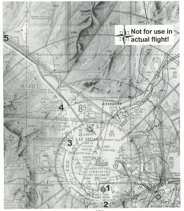
You can’t just blast off from Henderson Sky Harbor, however, and go along your merry way; there’s that big inverted wedding cake of Class B in your way. You’ll have to find a way to circle it to the west before you pick up your heading out of town.
This flight is another example where flying in FS 5.1 scenery can be much more difficult than navigating in the real world. The real world has roads and buildings and other landmarks that make it much easier to know where you are; not all of these details are present in the Las Vegas scenery, so you’ll have to resort to a mix of pilotage, radio navigation, and ded reckoning techniques to steer clear of the Class B airspace.
You’ll depart on Runway 18 from Henderson Sky Harbor. An altitude of 3,500 feet will give you sufficient room above the ground, but will still keep you low and out of the way of the commercial airliner traffic headed in and out of McCarren International. This will also keep you below the 4,000 foot floor of the Class B space to the southwest of the airport.
The outside edge of the 4,000 foot area of the Class B space is 8 nm from McCarren, which is also where the Las Vegas VOR (NEV 116.9) is conveniently located. You can use the DME readout on your navigation radio to help you stay 8 nm away from the VOR, which will give you a two-mile cushion from the Class B space.
As you swing around Las Vegas, keeping your 8 nm distance from the VOR, you will eventually come to a radio tower that is northwest of the city. If you were to continue on your curved path, you would run the risk of busting the Class D space around North Las Vegas Airport. To avoid this, you’ll change your heading to 345º (nearly true north) and take up a position parallel to Route 95. When the road turns northwest beyond North Las Vegas, you’ll intercept it and can follow it out of town. At that point, you’ll want to gain some altitude as the terrain rises; go on up to 4,500 feet to start.
|
Spotting Route 95 is much more difficult in FS 5.1 than it would be in real life. Instead of showing up as a road, it looks more like a faded or flattened patch in the scenery. The fact that it is in a fairly straight line helps you find it, and you can also use the map view zoomed out a bit to help see the big picture. Even so, I get a feeling that I’m flying over a post-apocalyptic, Mad Max landscape, following a road that has long-since disappeared.
The flight log that I have prepared shows the flight plan to this point. If you want, you can work out the rest of the details for the route to Lake Tahoe.
As promised, however, you won’t get there. When your DME readout shows 37.5 nm from the Las Vegas VOR, turn off your engine (use either mixture to full-lean cutoff, or switch off the magnetos by pressing M then the Minus key until the engine stops. You are now the pilot of a glider, and not a very good glider at that. Trim your airplane for the best glide speed—70 knots should work—and start figuring out where you’re going to put it on the ground. The desert can be an unforgiving place to lose an engine in a single, but who knows? Maybe this will be your lucky day....
Getting Ready to Fly
Henderson Sky Harbor Airport does have an entry on the World Airports list, but it is only for Runway 36. You can either use that choice to place your plane on the runway, then back taxi all the way to the other end, or you can enter the following values in the World Set Exact Location menu:
North/South Lat.: N 35 58 58.4
East/West Lon.: W 115 07 50.8
Altitude (ft): 2463
Heading (deg magnetic): 179
Then set your NAV1 radio to the Las Vegas VOR (116.9). You don’t have to be concerned about the OBS setting, because you’re only interested in the DME readout.
With that, you’re ready to roll. Just make sure that you stay clear of the special use airspace, watch for traffic, find that elusive Route 95, and don’t forget to kill your engine at 37.5 nm from the VOR. Let’s hope that Fortune smiles on you....
< Situation file: XC-LV3
Table of Contents
Previous Section: Making a Pass — Temple Bar to Henderson Sky Harbor
Next Section: Section C: New York Add-on