Realistic Commercial Flying with Flight Simulator
by John Rafferty
Chapter 14
Air Express Service: San Diego to Van Nuys
Climbing out of the right-hand seat of the Mission Aviation's number three trainer, a blue-and-white Cessna 152, you're happier than usual to be back on solid ground.
Your student is a nine-year-old “whiz kid” who's just had his third flying lesson, and you stand there shaking your head in quiet amazement as you watch him edge off the pillow that had him propped up on the pilot's seat. He stretches his left leg down through the open door to locate the footrest, manages to swing himself onto the pavement without a mishap, turns back to you with a satisfied grin, and snaps you a military salute.
You return the salute with a chuckle, and the two of you start across the ramp toward the office. He's a great kid, and you're delighted to be his instructor, but he's proven to be a handful. Since he seems to know as much about flying as you do and is always one step ahead of you, every minute of the one-hour lesson is much harder work for you than it is for him.
So now you're ready for a change of pace. That's the only reason you don't object as Sadie, the dispatcher, immediately accosts you when you arrive in the office. She has a rush-express assignment—a solo job with no student to coach or passengers to entertain—and it's just what you need right now when you're feeling so completely talked out. Sadie gives you the particulars and advises you that Four Six Fox, the new Cessna Skyline, is gassed up and ready to go.
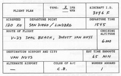
Your rush assignment is a Mission Express delivery to Van Nuys. A local firm is negotiating a subcontract on a large government research project, but their FAX machine has just broken down and they need to have a document at the Van Nuys Airport as soon as possible. Ordinarily, you would view this as a dull and routine assignment, but right now the solo flight fits your mood just fine. Besides, it's a gorgeous afternoon for the scenic ride up along the coast.
Preflight
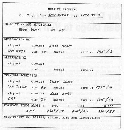
Pilot's Analysis of Preflight Weather
It's clear all the way, except for the usual scattered cumulus. Of course, here along the coast you can always get some local cloud developments that are not in the forecasts, but you can expect excellent VFR conditions for most, if not all, of the trip.
You have the usual winds from the southwest. This gives you a crosswind to compensate for, but you have a tailwind component as well to speed you along.
Pilot's Overview of Flight-Planned Route
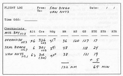
It looks like Victor 23 from Mission Bay through Oceanside to Seal Beach. From Seal Beach, you'll try flying direct to the Van Nuys VOR. With westerly courses on each leg, 6000 looks like the obvious altitude.
The wind at your cruising altitude should be about 210 degrees at 20 knots, so you use that forecast with your 120-knot airspeed to estimate the probable heading and ground speed for each leg—using a pencil when you enter those estimates on the log.
|
Departure
On the Ramp, When Ready to Copy
Cessna Three Zero Four Six Foxtrot
Cleared to the Van Nuys Airport
Flight-planned route
Maintain six thousand
Squawk one two three three.
You read back and indicate ready to taxi.
Four Six Foxtrot
Cleared to taxi for Runway 13.
You turn right, briefly paralleling the main runway, and turn right again to 310 degrees to taxi along parallel to Runway 13.
Approaching the Threshold of Runway 13
Four Six Foxtrot Tower on one eight point three.
Switch
Four Six Foxtrot position and hold.
When the Main Runway Is Clear of Traffic
Four Six Foxtrot cleared for departure
Runway 13
Altimeter three zero point one zero
Wind one seven zero degrees at ten
Visibility twenty-five miles
Temperature 63
Caution wake turbulence.
Upon Liftoff
Four Six Foxtrot turn left
Heading zero five zero degrees
Climb and maintain two thousand
On 500 FPM Climb, Heading 050 Degrees
Four Six Foxtrot turn left
Heading three five zero degrees
Contact San Diego Approach on one two zero point six
Good day.
Switch.
On Heading 350 Degrees
Four Six Foxtrot San Diego Approach
Turn left heading two niner zero degrees
Vector to the Airway.
On Heading 290 Degrees
Four Six Foxtrot San Diego
Climb and maintain six thousand
Resume normal navigation.
10 Miles DME Before Oceanside
Four Six Foxtrot San Diego Approach
Contact San Diego Center on one twenty-four point seven so long.
Switch.
15 Miles DME Before Seal Beach
Four Six Foxtrot Los Angeles Center
On one twenty-seven point one bye now.
Switch.
18 Miles DME from Van Nuys
|
Four Six Foxtrot Burbank Approach
Turn right heading three three five degrees
Vectors to the localizer
Descend and maintain four thousand seven hundred
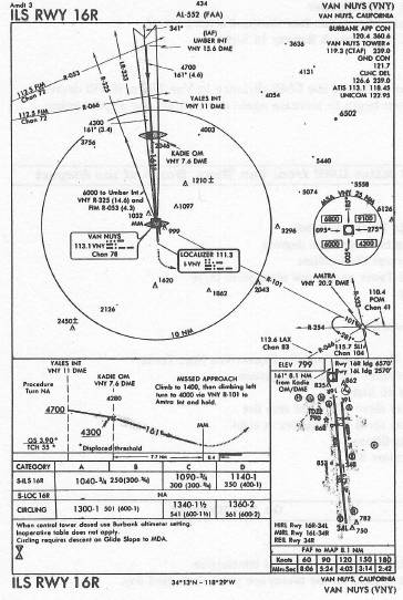
Expect ILS approach Runway 16 Right.
You monitor the DME distance to Van Nuys; it will decrease and then begin to increase again as you pass the airport going north.
15 Miles DME from Van Nuys, North of the Airport
Four Six Foxtrot turn left
Heading two four three degrees
To intercept the localizer
Contact Tower on one one niner point three
So long.
Switch.
Cessna Three Zero Four Six Foxtrot Van Nuys Tower
You're cleared for the ILS approach
Runway 16 Right
Altimeter three zero point zero five
Wind one seven zero degrees at eight
Visibility fifteen
Temperature 67.
On the Runway
Four Six Foxtrot turn left next intersection
Contact Ground on one twenty-one point seven good day.
Four Six Foxtrot ground where to?
You tell them you're heading toward the Butler hangar.
Four Six Foxtrot you're cleared to taxi straight across to Butler
Briefing 14
Wind and Altitude
As you climb from the surface to higher altitudes, the wind velocity usually increases and the wind direction shifts to the right. If you know the direction and speed of the wind on the ground, you can make a rough estimate of the wind conditions aloft. Generally, you can expect the wind at 2000 feet above the surface to be about double the surface wind speed and to have a direction 20 to 40 degrees to the right.
For example, if the wind at the airport is from the north at 15 knots, the wind at 2000 feet above the field is probably from the northeast at about 30.
Solving Wind Problems
Flight calculator. When planning a flight, it's helpful to estimate in advance the heading you need on each leg to compensate for the wind. If you have the winds-aloft forecast and a conventional flight calculator, you can make such an estimate for each leg of the flight in just a moment or so.
If you'd like to experiment, you can buy a simple mechanical flight calculator at any airport pilot shop. It's basically a kind of circular slide rule, and the instructions that come with it should be easy to understand—at least for the more basic kinds of calculations concerning you here.
Wind triangles. If you don't have a flight calculator, you can solve the same kinds of wind problems for flight planning purposes with just a sheet of paper, a ruler, and an ordinary dimestore protractor. Given your airspeed, course, distance of the leg, and the wind at your cruising altitude, you can easily draw a wind triangle that gives you two things:
- The heading you need to track the desired course.
- The resulting ground speed.
This approach is almost as quick as using a calculator—once you get the hang of it. You can even use it in flight (on the simulator) when flying a long leg, if your other cockpit duties permit. To solve the wind-corrected heading and ground speed on any given leg of a flight, follow the steps outlined below.
- From your chart, determine the compass course and the distance of the leg in nautical miles. Also obtain the forecast wind direction and speed for your cruising altitude.
- Near the middle of a sheet of paper, draw a vertical line for the north-south axis. Place a reference point P near the center of the line, as shown in Figure 14-5.
- With the aid of the protractor, draw a line from point P in the direction of your course. Label the line Course. For example, in the illustration, the course is 090 degrees.
- With the protractor, draw another line from point P, but this time in the direction of the wind. Label this line Wind. In the illustration, the wind is from 045 degrees.
- Determine that one inch on the ruler equals a speed of 20 knots. (Or you can adopt any other scale you find convenient.)
- Lay the ruler along the Wind line. From point P, measure along the Wind line a distance representing the wind speed and mark the point W. For example, in the illustration, the wind speed is given as 40 knots; since one inch equals 20 knots, W is placed two inches out from point P.
- On the ruler itself, measure from the zero mark a distance representing your airspeed and place a pencil dot at that point. For example, if one inch equals 20 knots and your airspeed is 120 knots, make the pencil dot at the six-inch mark on the ruler.
- Place the ruler on the diagram with the ruler's zero mark at point W.
- Keep the ruler's zero mark on point W while you rotate the ruler, so the pencil dot is right at the Course line. Place a mark at that point on the Course line and label it C.
- Draw a line connecting points W and C.
- Heading. The angle of the line from W to C is the heading, enabling you to track the specified course in this wind. In the example, the heading is found to be 076 degrees.
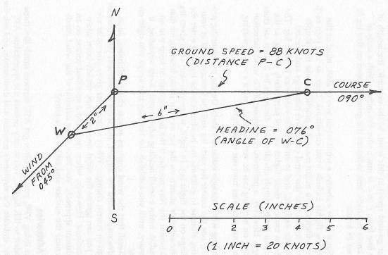
- Ground Speed. The length of the Course line from P to C indicates your ground speed in this wind. In the example, the length of the line from P to C is just under 4½ inches. With a scale of 20 knots per inch, this indicates the ground speed on this leg is about 88 knots.
Since there's always a wind when you're aloft, most of the remaining flights include wind conditions. Thus, as you plan each of these flights, you might make it a practice to use this simple method to estimate the wind correction headings and ground speeds for each leg, and to enter those estimates in your log. The winds on most of these flights are not particularly strong, so the ETEs you get by simply dividing the distances by 2 often are close enough. However, a preliminary estimate of the wind correction heading on each leg can be very helpful, and it's very satisfying when your estimates turn out to be right.
Using wind-triangle estimates aloft. During the planning procedure, use the course for each leg and the forecast wind at your cruising altitude to estimate the heading for the leg, and enter the headings on the flight log. In flight, when you start on a given leg, use the estimate shown on the log as your initial heading for that leg. Monitor the Nav needle; if the heading fails to keep you on the radial, make a small heading adjustment. Keep adjusting, if necessary, until you establish the heading that keeps you right on course.
Recall that the wind changes as you change altitudes, so as you descend toward the airport, the wind adjustment you need for any given course changes. When a controller gives you radar vectors, you can ignore the wind since that has already been taken into account. However, when you need a specified course on an instrument approach, you have to be mindful of the wind conditions near the surface and adjust as required.
VFR Advisories
When flying VFR, you can often get ATC services much like those provided to IFR flights. You simply contact the appropriate ATC facility, indicate the airplane's position and destination, and ask the controller to provide you VFR advisories. If the workload permits, the controller can give you a transponder code, monitor your flight on radar, and advise you of other traffic along the way.
In particular, as you approach your destination, you'll auto-
matically be handed off to Approach Control for vectors to the airport. Approach hands you off to the Tower for a landing clearance, very much like an inbound IFR flight.Wake Turbulence
When an airplane's wings develop lift, a vortex is created—a kind of violent whirlpool descending downward from each wingtip. If the airplane is on or near the ground, the vortex drops down and moves out to each side.
Such wake turbulence is especially dangerous when produced by a heavy, relatively slow aircraft, easily causing a light plane to spin about and invert if caught in such a disturbance. As a result, tower controllers often caution pilots about possible wake turbulence when large aircraft are operating in the area. (Of course, if you do encounter such a wake, there's not much you can do except hold on tight.)
Table of Contents | Previous Chapter | Next Chapter