Realistic Commercial Flying with Flight Simulator
by John Rafferty
Chapter 4
IFR Check Ride to Hartford
Well, maybe it was a little early for lunch, but what the hay, we've earned it. Now let's get ready to head for Hartford.
Preflight
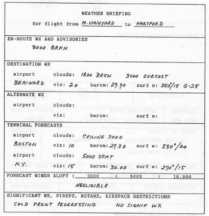
Preflight Weather
Take a look up there: They're still calling it broken, but from here it sure looks like a solid overcast—not that it really matters, though.
It looks like we can expect two thin cloud layers at roughly 2000 and 3000 feet—at least around here. So if we request 6000 feet, we should be in VFR conditions on top for most of the trip. Also, with ceilings of 2000 feet or so, no airport is likely to be close to minimums, so we needn't be concerned about an alternate airport.
It's a bit gusty at Hartford right now, but that's probably the front moving through; it might calm down by the time we get there. The main thing is that no thunderstorms have been reported in connection with the frontal movement.
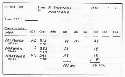
Flight Log
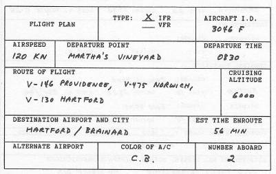
We can figure on the same route back—at least as far as Norwich, where we'll head up to Hartford instead of Madison. This makes the flight log easy to prepare: Except for the last leg to Hartford, we already have the checkpoints set up, the distances are figured out, and the return headings are just the reciprocals of those we used on the way out.
|
Departure
On the Ramp at MVA, After Contacting Ground
Four Six Foxtrot Ground ready to copy?
Reply affirmative.
Cessna Three Zero Four Six Foxtrot
Cleared to Hartford Brainard
Victor one three zero to the Hartford VOR
Maintain four thousand
Squawk two three three zero
Ready to taxi?
Such is life! They've given us V-130 all the way—the routing we probably should have requested in the first place.
Don't start to taxi until you know which way you want to point the airplane after takeoff. Instead, tell Ground Control, “Ground, Four Six Foxtrot, stand by one,” and pull out your chart.
- Note that V-130 runs from MVA to Norwich on heading 294 degrees.
- Set Nav 1 to 108.2 for MVA.
- Set the Nav 1 bearing to 294 degrees for the Airway.
- Tell Ground Control, “Ground, Four Six Foxtrot ready to taxi.”
- You can figure out the rest of the log later on.
Four Six Foxtrot cleared to taxi for runway 24
Turn right there on the ramp and follow the parallel taxi strip.
Near the End of the Taxi Strip
Four Six Foxtrot Tower on one twenty-one point four.
Switch.
Four Six Foxtrot Vineyard Tower position and hold.
In Position and Holding on Runway 24
Four Six Foxtrot cleared for departure
Runway 24
Altimeter two niner point zero six
Wind two three zero degrees at seven
Visibility ten miles
Temperature 61
Departure heading two niner four degrees
- Note the time, and take off when ready.
- After liftoff, turn right to 294 degrees.
At Altitude 1000 Feet
Four Six Foxtrot
Climb and maintain three thousand
Contact Otis Approach on one twenty-four point seven good day.
Switch.
Four Six Foxtrot Otis Approach
Turn right heading three two zero degrees
Vector to Airway Victor one thirty
Climb and maintain four thousand
Resume normal navigation
- Turn to 320 degrees and monitor Nav 1.
- When the Nav 1 needle centers, proceed on R-294.
- Note that they've given us 4000, not the 6000 we requested.
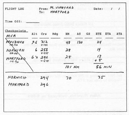
When you have a chance, work out your revised flight log. Just use Norwich as the first checkpoint.
20 Miles DME from MVA
Four Six Foxtrot Westchester Center on one thirteen point niner So long.
- If you wish, set Nav 2 to 115.6 for Providence.
- Toggle the Nav 2 OBS to center the needle with the flag reading FROM.
- From time to time, recenter the Nav 2 needle as a position check.
What's our ETA at Norwich?
About Halfway to Norwich
- Set Nav 2 the same as Nav 1.
- Leave the Nav 1 OBS set to the Airway radial.
- Switch Nav 1 to 110.00 for Norwich.
- If necessary, make turns to recenter the needle.
10 Miles DME from Norwich
Four Six Foxtrot Westchester Center
Descend and maintain three thousand
Contact Bradley Approach on one twenty three point eight five
Good day.
2 Miles DME Before Norwich
- Set Nav 1 bearing to 296 degrees, the outbound course.
- Prepare to note our ATA.
After Norwich, Outbound on R-296
- Set Nav 2 the same as Nav 1.
- Set Nav 1 to 114.9 for Hartford.
- Turn as required to recenter the Nav 1 needle.
- Reset Nav 2 the same as Nav 1 again, as backup.
ETA at Hartford?
Four Six Foxtrot Bradley
Descend and maintain two thousand four hundred
Expect the VOR-A approach to Brainard.
Find the approach plate and begin studying it.
10 Miles DME from Hartford
Four Six Foxtrot Brainard Tower on one one niner point six.
Switch.
At this point, users with ADF equipment can skip the remaining instructions and try the NDB-B approach to Brainard, if desired.
Cessna Three Zero Four Six Foxtrot Brainard
Maintain twenty-four hundred
Hold at the Hartford VOR
On Hartford R three three four
Right-hand turns
Expect VOR-A approach to Brainard.
- Check Nav 1 and Nav 2 on 114.9 for Hartford.
- Switch the Nav 1 bearing to 334 degrees, the approach heading.
- Fly Nav 2 to the VOR.
Locate the holding pattern on the approach plate.
Upon Arriving at the Hartford VOR
- Start a half-standard-rate right turn to heading 154 degrees.
- Remain on heading 154 degrees for one minute.
- Start a half-standard 180-degree right turn to 334 degrees.
- Intercept R-334 and track inbound.
- At the VOR, start another 180-degree right turn to 154 degrees.
- Repeat the pattern until cleared for the approach.
After Three Times Around the Holding Pattern
Cessna Three Zero Four Six Foxtrot Brainard Tower
You're cleared for the VOR-A approach
Altimeter two niner point niner zero
Winds calm
Visibility twenty miles
Temperature 63.
- Continue in the holding pattern until inbound on R-334.
- At the VOR, begin a 500 fpm descent on heading 334 degrees.
- Keep the Nav 1 needle centered.
- Level off at 1100 feet—unless the airport is in sight at that point.
- If the airport isn't visible at DME 7.3, you have a missed approach.
There's no wind. Pick your runway and land.
On the Runway
Four Six Foxtrot Ground on one twenty-one point six so long.
Four Six Foxtrot Ground
You're cleared to taxi to transient parking.
Briefing 4
VOR Approaches
Many airport runways have no ILS system, but there are other kinds of published instrument approaches. Most of these use one or more conventional VORs to guide the pilot to the runway. The exact procedures vary widely from one VOR approach to another, but each will provide at least three main elements. These are:
- The final approach fix (the point at which you begin your descent).
- A VOR radial that you track upon descent.
- A minimum altitude to which you may descend unless you have the runway in sight.
Most VOR approaches guide you down to a specific runway on a heading that's at least approximately lined up with that runway. However, sometimes the VOR location and runway direction make a straight-in approach unfeasible; in such cases, there may be a VOR approach that gets you down to the airport but not to a specific runway. Once you have the airport in sight, you then have to circle to land on one runway or another, depending on the wind. Such an approach is referred to by a letter instead of a runway number, such as a VOR-A or VOR-B Approach.
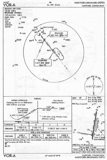
The VOR-A Approach to Hartford/Brainard
As the approach plate shows, this approach begins at the Hartford VOR. You arrive at the VOR on R-334 at 2400 feet. You begin your descent at station passage, track outbound on R-334 as you descend, and go no lower than 1100 feet until you have visual contact with the airport. A standard 500 fpm descent usually works out just right.
As you come in over the airport, you won't be aligned with any particular runway. So when the airport is in sight, consider the direction of the wind and circle to land on the runway of your choice.
Holding Patterns
At various points on aeronautical charts, you see a racetrack-shaped oval identifying a holding pattern. For example, on the plate for the VOR-A approach to Hartford notice such a pattern at the Hartford VOR. IFR flights are often assigned to hold in such a pattern to allow ATC to regulate the flow of traffic.
If you're assigned to hold, the controller indicates each of the following:
- The navigational fix at which you should hold.
- The VOR radial you're to hold “on” (the radial you'll be on when you're in the oval and inbound to the holding fix).
- Either right-hand or left-hand turns to make.
For example, instructions for the holding pattern shown on the Hartford VOR-A approach would be:
Hold at the Hartford VOR on Hartford R-334, right-hand turns.
Thus, you would fly directly to the VOR and turn right to heading 154 degrees. That would put you on the outside of the oval, heading outbound. You would fly that outbound heading for one minute, make a 180-degree turn to the right to intercept R-334, and track inbound to the VOR. At the VOR, you would again make a 180-degree right turn to the outbound heading of 154 degrees and repeat the process.
Then, when traffic permits, ATC would clear you to leave the holding pattern and proceed in accordance with your clearance.
En-Route Altitudes and Headings
On IFR flights above 3000 feet, the altitude selected depends on the heading:
- On easterly headings (000-180 degrees), use odd thousands of feet (5000, 7000, 9000).
- On westerly headings (180 to 000), use even thousands of feet (4000, 6000, 8000).
VFR flights use the same rules but add 500 feet to the altitude (such as 5500 on an easterly heading or 6500 on a westerly heading).
Going on Instruments
When there's no visible horizon, you must control the aircraft by reference to instruments alone. (Of course, to fly in such conditions, you must be on an IFR clearance.) When you enter clouds, the windshield becomes all gray and your first concern is not to panic. If the airplane is straight and level when you enter the clouds, it will probably stay that way at least for a while.
Instrument flying is an art with a number of important ingredients. One is that you must develop complete and total trust in what the instruments tell you. Another is that you must develop a smooth, consistent pattern for scanning all the instruments—keeping your eyes and attention constantly in motion, never allowing your attention to become fixed on any one particular instrument or another.
Perhaps the easiest flight instrument to use when you're “socked in” is the artificial horizon. It's very much like having a periscope that pokes up through the clouds, giving you a view of the horizon you can't see through the windshield. Still, you shouldn't depend on it entirely; keep scanning all other instruments as well—airspeed, altitude, heading, RPM, attitude, airspeed, altitude…and so on.
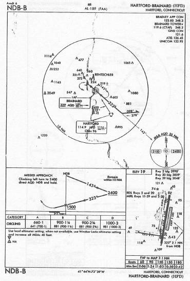
NDB Approaches
A less popular type of instrument approach is one based on a non-directional beacon (NDB) instead of a VOR. NDB approaches, which are also called ADF approaches, require the aircraft to be equipped with ADF. The IBM version of the program is not so equipped, but users of other versions might want to experiment.
At Hartford, there's an NDB-B approach. Arrive at the Hartford VOR at 2400 feet and start your descent as you proceed outbound, using the ADF to home on the Brainard NDB. Stay at 1500 feet or above until station passage. At the NDB when the needle drifts around to the bottom of the window, turn left to heading 323 degrees and continue the descent.
Automated Terminal Information Systems (ATIS)
At many large airports, pilots can tune in a special Com frequency to get a recorded announcement giving the current altimeter setting, wind, visibility, and so on. The ATIS announcements are updated frequently, and each revision is given a code-letter identity, such as Information Kilo or Information Charlie.
To save time, pilots are encouraged to get the current ATIS information before they contact the tower and to advise the controller that they have “Information Kilo,” or whichever update is current, so the controller won't need to repeat it.
In practice, the ATIS frequency at any given airport is different from the control tower frequency. For the program, however, where control tower frequencies are given on program charts, entering that Com frequency usually provides a text display of the current ATIS recording. The message is consistent with any cloud or wind conditions you've set up on the program, and the runway in use will be consistent with the wind direction.
Table of Contents | Previous Chapter | Next Chapter