Runway USA
A pilot's guide to destination cities in Flight Simulator
by Charles Gulick
Tale of Two Cities
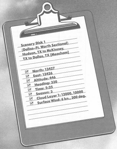
Why are we starting a tour of the western U.S. from Hudson, Texas?
Back in the days before the word “hippie” meant anything, there was a musician and philosopher named Moon Dog who used to be seen on the streets of New York City. Clad usually in a sheet, wrapped about him like a Roman toga, he had a classic air. He invented his own instruments, and was also a pianist of sorts. One night, while playing flute on the shore of the Hudson River, he recorded a duet with the Queen Mary's haunting whistle as it plowed its way upstream. On the same disk he recorded a soliloquy while improvising at the piano.
Two of the thoughts in the soliloquy were memorable. One went something like “people ask me if I dress the way I do to attract attention.” (Pause, with piano filigree.) “I attract attention because I dress the way I do.” The other was, “To square a circle, start anywhere.”
I'm not sure the last quote was original with Moon Dog. But it explains why we're starting a tour of the western U.S. from Hudson, Texas, doesn't it?
I must say that of the hundreds of places I've flown to and from in the simulator, Hudson is the only town I am unable to locate in any of eight atlases, an almanac, and six or seven other place references I use. Some of the atlases list towns with populations as low as 50 people, but no Hudson. Yet this town is big enough to have an airport of its own, and even an NDB (Non-Directional Radio Beacon). Perhaps it isn't a town at all, but simply an airport location.
Anyway, this is what Runway 35 at Hudson Airport looks like at dawn. Daylight will come at 5:30 a.m., so don't take off until then, because I would like to show you a couple of lakes on our way to McKinney Airport, and the simulator doesn't depict misty lakes at dawn very well.
Switch on radar and zoom up until you see five lakes, two cities, and some highways. The cities are Dallas (to your immediate left) and Ft. Worth, Texas, which we'll fly by on the second leg of this morning's triangular flight. The lakes just ahead of you are named Lake Ray Hubbard and Lavon Lake. The one to the north of Dallas is Lake Dallas.
Return to your out-the-windshield view.
We want to fly a heading which will take us directly over Lakes Hubbard and Lavon, and if you look at your sectional you'll see that we can track a Blue Ridge VOR (Very High Frequency Omnidirectional Range) radial to do just that.
Tune Blue Ridge on 114.9 and center your OBI (Omni-Bearing Indicator) needle.
Okay. So we want radial 8, and unless or until the wind tells us differently, 8 degrees will be our heading. Plan a cruise altitude of 2000 feet, and take off when you're ready.
Climb out to about 900 feet, then make a shallow turn to the right to intercept the OMNI spoke.
The highway you see crossing Lake Ray Hubbard, or trying to, is Interstate 30. Whoever digitized the highways and lakes in this Scenery Disk apparently first laid down the highways, and then put the lakes on top of them. In real life, of course, it's the other way around.
Since the wind is from your left, you'll no doubt wind up crabbing to the left to keep the needle centered.
By the time you reach Lake Lavon, you'll be flying along its eastern shore. Take a left front view and you'll see McKinney Airport. But stay on your heading.
When you reach the northern tip of the lake, turn left to a heading of 260 degrees. Then you should see McKinney Airport ahead of you. Correct your heading as needed to keep the runway well to your left, and again get on a heading of 260 degrees. You'll be flying an extended crosswind leg for Runway 35, but above pattern altitude. We're going to fly beyond the runway, then enter the downwind leg at a 45-degree angle.
As you approach the airport, transition to slowflight. After you pass the end of the runway, begin a gradual letdown to pattern altitude. Since the elevation at McKinney Airport is 581 feet, figure a pattern altitude of 1500 feet.
Seeing that the downwind leg heads 170 degrees, you know your entry heading should be 170 minus 45, or 125 degrees. Based on your relationship to the strip, decide whether circling to the left or right will put you in optimum entry position. The exact heading on entering downwind is not the critical thing. The reason for entering a pattern at a 45-degree angle is so you can see other aircraft which might be flying the pattern, and they can see you.
Take any views you need to stay aware of the runway position in relation to your position. Remember you'll have to fly far enough beyond the runway to turn back and approach it properly. If you miss, keep flying and repositioning yourself until you get it right.
Once downwind, go ahead with your approach (base leg heads 80 degrees) and use full flaps for your landing. But wait! We're going to “touch and go.” Here's how.
Once in the landing roll:
- Take off carburetor heat. (I hope, you had it on!)
- Trim your elevator to its usual takeoff position. (Approximate it as best you can.)
- Change your flap setting to 10 degrees (takeoff setting).
- Add full power.
- Proceed with your normal takeoff.
That's called “touch and go.” It's like a kiss and a promise. We landed at McKinney Airport and took off again, all in one smooth operation. Right?
If by any chance you failed, don't worry; I won't leave you behind. Go into the Editor, press Recall to return to the Hudson mode, and set the standard North and East parameters for McKinney Airport given in your manual (13616N, 13419E), and you'll be at McKinney Airport with no change in weather or wind. Then just taxi to Runway 35 and rejoin the group.
If you touched and went okay, you can fine-tune your elevator setting as you climb out, checking for operational neutral at your usual climbout RPM (2105 in Cessna, 2250 in Piper, unless altitude dictates otherwise). You should be climbing, eventually, at 500 FPM.
Our destination now is Dallas Meacham Airport. We'll use the same cruise altitude of 2000 feet.
As you climb, make a left turn to head approximately 185 degrees. This should point you toward the approximate center of the city of Dallas. Use radar to check on your position and direction. We'll fly contact from this point on, the idea being to follow the northern outskirts of Dallas and Ft. Worth so we can view them out the left side.
Your standard cruise RPM for this altitude (1905 in Cessna, 1950 in Piper) should get you straight and level at 2000 feet without any further elevator adjustment (given, again, that you're at operational neutral).
Dallas, which Texans call “Big D,” is a giant stage-set for a popular television series. When and if the series is ended, Dallas will be taken down and stored in a warehouse somewhere.
Kidding aside, it's been said that Dallas grows so fast that the skyline changes every week. Three-quarters of all known U.S. oil reserves are within 500 miles of here, and it was oil—along with cotton and cattle—that nurtured the city's growth.
Dallas was also the scene of one of the unhappiest days in modern American history—November 22, 1963—when President John F. Kennedy was assassinated while riding in a motorcade through the city. The youngest president we've had, he was at the peak of his popularity. No one who experienced that day can forget where he or she was when the news broke. I was entering an office building on Fifth Avenue in New York, with a party that included a U.S. Army officer in uniform. We were returning from lunch, and were just about to enter the building when a woman confronted our military friend with the words, “Your commanding officer has been shot.”
Dallas is much more than oil fields and farms. The second largest city in Texas, it's the Southwest's major commercial, financial, and transportation hub, and is a key center for research, space technology, and fashion.
Out the right front you should be able to spot the runway at Addison Airport. Directly ahead of you is the site of the University of Texas at Dallas. In the heart of town, a bit left of your course, is the Cotton Bowl, just south of Interstate 30. As you get closer, an airport will come into view on the right side of your screen. It's Love Field, nestled right inside the metropolitan area.
When there's no more earth, but only city, at the bottom of your windshield, turn right to a heading of 240. You'll have Addison Airport on the right and Love Field on the left of your windshield, and you'll be approximately parallel with Lyndon B. Johnson Freeway.
The highway you see just beyond Addison Airport is Interstate 35 East, which with its counterpart 35 West forms an ellipse linking the metropolitan centers of Dallas and Ft. Worth.
When you're about opposite the end of Runway 15/33 at Addison Airport you'll see Dallas Love Field and Addison Airport on radar. Note Love's parallel strips, and take a look out the left front, too, as you fly.
Then watch ahead, because the biggest airport in the United States is about to rear up—Dallas-Ft. Worth Regional. Where but in Texas would you expect to find the biggest anything? The airport was opened in 1974, and lies halfway between its namesake cities.
Point to fly straight over the center of this massive facility, with its five strips, all of them except Runway 13/31 well over two miles long. As you approach Dallas-Ft. Worth Regional, look off your right wingtip and you'll see Lake Dallas, just east of Interstate 35 East.
The first runway you'll cross is the little one—short by Texas standards, but wide enough to accommodate even the wildest student pilot. The remaining runways are parallel pairs, 0/18 and then 17/35. Try a straight-down view as you cross all these strips.
Although they are often thought of together, as “Dallas—Ft. Worth,” these two cities are by no means twins. It's a classical maxim that “Dallas is the place where the East ends. Ft. Worth is the place where the West begins.” Ft. Worth also used to be known as “Cowtown, U.S.A.,” when it was a large cattle-trading center. The smaller communities between these two large cities are referred to locally as “the Mid-Cities.”
As for style, Dallas is the dude; Ft. Worth is the ranch. Where the Ft. Worth stockyards used to be, you'll now find cowboy bars and—the largest in the world, naturally—the nightclub called Billy Bob's Texas, comprising more than three dozen bars, an honest-to-goodness rodeo, and entertainment by country stars such as Willie Nelson.
Go into radar and adjust to the view which shows you a good portion of the Interstate 35 East and Interstate 35 West ellipse. At about 11 O'clock from your position, Interstate 35 West cuts into the northern edge of Ft. Worth, and you'll see another highway, Interstate 45, just beyond. Our destination airport, Dallas Meacham, is on the edge of Interstate 45 just north of the metropolitan area.
Our landing will be on Runway 34 Left, and elevation is 708 feet. Airport traffic necessitates a left-hand pattern, so you'll fly beyond the field and negotiate a downwind entry, just as you did at McKinney Airport.
Table of Contents | Previous Chapter | Next Chapter