Runway USA
A pilot's guide to destination cities in Flight Simulator
by Charles Gulick
Oklahoma!
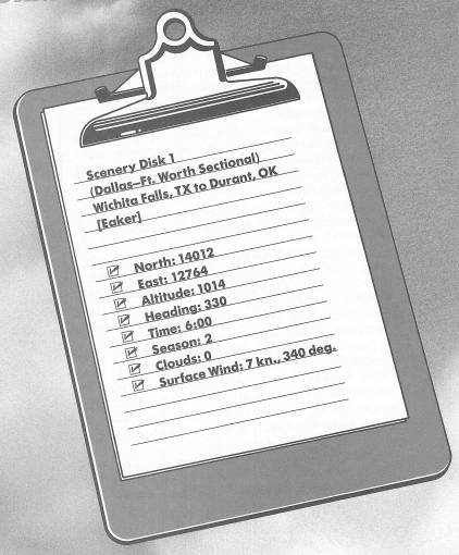
Runway 35 at Wichita Falls is just ahead. If your panel is blacked out, turn on your lights.
We'll be flying a bit more than a hundred miles this morning, and I want us to be about halfway to Durant before daylight. So let's take off immediately.
Climb out to 1500 feet. Then turn right, heading 85 degrees.
Level off at 2500 feet.
That's some town, Wichita Falls, loaded with memories for me. I was stationed there for a while in the Army, at what's now Sheppard Air Force Base. I drank my first boilermaker there, in a place that looked like a huge barn and old mill, somewhere near the river, at the tender age of 18. And a few hours later I drank my last boilermaker, forever.
That line below the horizon is the Red River. Rising in New Mexico and flowing over 1200 miles into the Mississippi River and the Gulf of Mexico, it forms a natural boundary between Texas and Oklahoma.
Take a good look back at Wichita Falls, out the right rear window.
Radar will show you your relationship to the river as you fly. You'll be flying over Texas and, sometimes, over Oklahoma. The highway bending south is U.S. 287.
Just about everybody on earth is asleep down there below us—in the small towns of Dean, Petrolia, Riverland, Henrietta, Ringgold, Rowland, and Nocona.
Soon you'll see a highway on the horizon. It's Interstate 35—the same one that forms an ellipse south of here to link Dallas and Ft. Worth, remember? You'll probably be able to pick out the ellipse on high-altitude radar, and, presently, the cities themselves. Interstate 35 also delineates, approximately, the Old Chisholm Trail.
When the sun rises, you'll see you're headed for a good-sized body of water. It's Lake Texoma—and guess where it got its name.
You're probably pointed for the approximate center of the lake, which is fine. Until its full dimensions are revealed, however, it'll look like you're headed along the southern shore. Check radar.
As you cross Interstate 35, take right front and right side views. You will be just able to make out the edges of the Dallas-Ft. Worth metropolitan areas. And that's some visibility. They're about 65 miles south of you. You should be able to spot, much closer by, the runway at Gainesville, Texas, too.
Check Lake Texoma on radar, and correct if necessary to point for the approximate center of the eastern shoreline, which looks like a wave swell or sine wave.
Check your sectional chart to see how and why I'm pointing you over the lake this way.
Start a 500 FPM letdown to about 1700 feet when you're over the lake. We're still quite a distance from Durant, but you might as well take in the lake scenery from a lower altitude. Also, that will put us at pattern altitude when we get where we're going. The field elevation at Eaker Field is 699 feet MSL.
Keep checking your radar and make further heading corrections as needed to point where you want to go.
Now just keep a lookout for the airport ahead. We'll land on Runway 35. Your downwind leg entry heading is 125. Get into slowflight as soon as the strip is in sight.
Table of Contents | Previous Chapter | Next Chapter