Runway USA
A pilot's guide to destination cities in Flight Simulator
by Charles Gulick
Time and the River
For me, the most memorable flight in my early simulator experience wasn't flying over Manhattan, or buzzing the great landmarks there and elsewhere in the Flight Simulator disk, but meandering along the Kankakee River in Illinois. There's something about rivers…whether you're tracking them in a boat, or cruising above them in a light airplane.
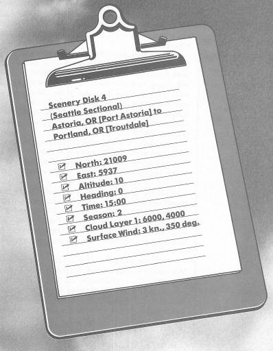
Furthermore, only a few rivers in the simulator or the Scenery Disks are truly dimensional—that is, consist of more than just a thin blue line—because they're simply not wide enough to digitize realistically. A bit later in this book, we're going to travel down one of the widest. But this afternoon we'll track the beautiful Columbia, from here at Astoria, where it empties into the Pacific Ocean, to its nearly southernmost point in Portland. We'll be flying along one of the river's widest stretches.
I've chosen a short takeoff (as you can see on radar, you're just above the intersection of the three strips) because it affords the most satisfying and realistic “feeling” as you climb out low over the water. Cruise at low altitude—1500 feet—to keep everything intimate.
Take off, and stay on your upwind heading until you're beyond that promontory you'll see ahead. Then use radar and your out-the-windshield views to line up toward the point where the river takes its first sharp bend south-eastward. Take a look behind you when you have your heading, and see that pretty airport, pristine in its setting of ocean and river.
The Columbia River rises in Canada, in the Rocky Mountains of southeast British Columbia, and flows a total of 1214 miles between Washington and Oregon. Many dams, including the concrete Grand Coulee in central Washington, convert its vast hydroelectric potential into power. (More than ten billion watts are generated at Grand Coulee alone; that's a lot of light bulbs.)
The highway that presently appears ahead of you is Interstate 5, which traverses south from Elaine, Washington, to San Diego, California.
Some of the towns on the Columbia's Washington banks are Chinook, Knappton, Altoona, and—just at the turn—Skamokawa. On the Oregon side, besides Astoria, are the towns of Fern Hill, Svensen, Knappa, and—opposite Skamokawa—Brownsmead.
Needless to say, turn with the river, and use your right side and radar views in order to stay over the middle of the water and to position yourself for the next turn, which is briefly eastward again. On your left you'll be passing Cathlamet, Washington, and on your right Westport, Oregon. Also on your right is Clatsop State Forest. Then, along the short stretch after you negotiate the point, are the towns of Marshland and later Clatskanie, Oregon, both a few miles inland.
Invariably, when I fly a river like this, I come under some kind of spell. I relax, more and more deeply, without necessarily intending to, and I could easily slip into reverie. Try a river sometime when you're uptight about something.
We are blessed in this country with great and resplendent rivers. Just to hear some of their names, even alphabetically, is to hear a kind of poetry, rich with the eloquent cadences of the American Indian: the Altamaha-Ocmulgee…the Apalachicola-Chattahoochee.…the Arkansas, Colorado, and Delaware…the Kanawha-New…the Kuskokwim…the Mississippi, Missouri, and Mobile-Alabama-Coosa. And toward the other end of the alphabet, the Sacramento, the San Joaquin, the Santee-Wateree-Catawba, and the Susquehanna. And yes, the Wabash, Washita, and White.
The first airport you'll see, before the Columbia turns to parallel Interstate 5, is Kelso-Longview. It's named for two neighboring towns in Washington, just this side of the highway. On the Oregon side is the town of Rainier. Soon after you turn southeast, the metropolitan areas of Vancouver, Washington, and Portland, Oregon, will begin to become discernible, though only intermittently at first.
Presently you'll arrive at a point where the river divides around an island. Follow the left fork, aiming for the open water you can see beyond it. You'll now also be able to spot two airports, Portland Hillsboro out the right front and Portland International out the left front. Follow the river to the point where it widens, and turn left with it. Then Portland and its big airport will be on the right side of the river, and the city of Vancouver on the left.
Just beyond Portland International Airport you should be able to spot the single runway at Portland Troutdale Airport, which is our destination. We'll land on Runway 7, and your best bet is to fly right across the intersection of Portland International Airport's runways (holding your altitude until you're clear), then transition to slowflight with carb heat and flaps, and get into position for a long final.
Use your left side views regularly to pinpoint your position until you make your turn to final. The elevation at Troutdale Airport is 36 feet.
Table of Contents | Previous Chapter | Next Chapter