Runway USA
A pilot's guide to destination cities in Flight Simulator
by Charles Gulick
How's Bayou?
Lake Charles, Louisiana, has a population of more than 75,000 today and is a major port of entry and shipping center for oil, lumber, cotton, and particularly rice. This port city is also the site of McNeese State University and Sowela Technical Institute.
But in 1781 it had a population of one, a Spaniard named Carlos Salis who came from New Orleans, built a house, and changed his name to Charles Sallier. Travelers named the little town that grew around him “Charlie's Lake.” So you can see how the present name evolved.
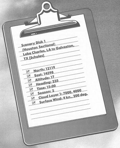
We're going to skim low over the Louisiana marshlands and bayou country, then make a landing approach over Galveston Bay to Scholes Airport. The whole flight will be at an altitude of about 900 feet.
You're in position to taxi ahead and depart via Runway 23. But before you go, tune your NAV to Sabine Pass VOR, 115.4. The station is just across the Texas—Louisiana border, and on the Gulf of Mexico. Set your OBS for a bearing to fly when you leave the airport pattern. You'll see that the runway heading puts you almost exactly on course.
Once you're on your heading at 900 feet, look out the left front window. The big lake (shaped like a hang glider when you look at it on radar, or like a square edge if you're viewing from the windshield) is Calcasieu Lake. You'll be crossing the Creole Nature Trail after you pass Calcasieu, and then the Sabine National Wildlife Refuge. There are lakes and bayous out there you don't see, and in fact anything that isn't a lake or bayou is at least pretty marshy and muddy.
When you have mostly green, or “land,” in front of you, take some rear views. It just looks soggy, doesn't it?
Louisiana is the country's major producer of rice and sweet potatoes, and one of the leaders in petroleum. The people of Louisiana are largely descended from French and Spanish settlers, who controlled the territory until the U.S. bought it in 1803 as part of the Louisiana Purchase. By the time of the Civil War, half of the population was slaves.
The big lake you'll fly over before you get to the Gulf is Sabine Lake. Northwest of the lake is Beaumont, Texas, intersected by Interstate 10.
When you're a few miles from Sabine Pass VOR, switch to Scholes VOR, 112.8, and get a new bearing to fly.
You'll be able to see the Gulf of Mexico off to your left, and if you look at your chart and/or radar you'll see you're flying toward the southern portion of Galveston Bay. Before long, the bay will begin to appear ahead of you.
On high altitude radar, you'll be able to see Houston, Texas. The highway leading to it is Interstate 10, which you'll probably be able to see out the right side.
Also, in front of you and on radar, you'll begin to make out a narrow peninsula, surrounded by the Gulf of Mexico and Galveston Bay. It's named Bolivar Peninsula, and you are—or should be—tracking up the right side of it.
Forget the OMNI now. You'll fly contact from here on in.
It's almost impossible to determine where the airport at Galveston lies from your chart. If you believe the symbol, it's right out in the Gulf of Mexico with no land under it. It's also virtually, if not literally, invisible using your out-the-windshield view. So I'll have to guide you in.
Notice, on your screen and on your radar, that Bolivar Peninsula turns sharply south and points a finger out into the Gulf of Mexico. Actually, it points to another strip of land, which only shows up when you're close to it. That land is Galveston Island.
So when you pass the edge of Bolivar Peninsula, and no longer can see any of it out front, turn left to a heading of 216. This will point you toward Scholes Airport, which will show up in a minute or so.
If you're in good position, a left turn directly to final for Runway 17 will probably be approved by the tower. Use radar to keep a check on your relationship to the strip.
And what a beautiful approach this is, isn't it?
Pure storybook.
Table of Contents | Previous Chapter | Next Chapter