Runway USA
A pilot's guide to destination cities in Flight Simulator
by Charles Gulick
One Small Step
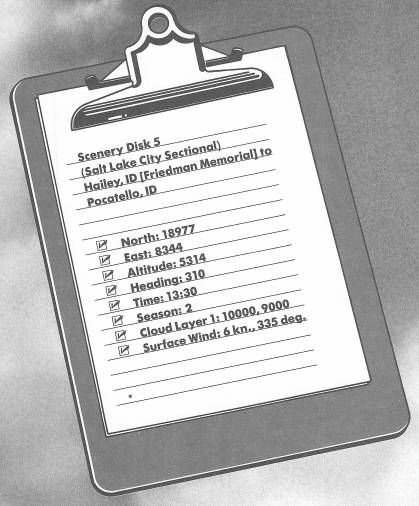
Taxi ahead to Runway 31, take off, and climb straight out to 6000 feet. Then start a two-minute turn to the right, and while you are turning, tune Pocatello VOR on 112.6 and center the OBI. The indicated radial is the one we'll fly to Pocatello Municipal Airport, so roll out of your turn and fly the needle.
You may wonder why a relatively narrow runway such as that at Hailey Airport is so long, but you should be able to infer the answer from the amount of runway consumed in your takeoff run. The airport is over a mile high.
Plan on a cruise altitude of 7500 feet.
You're flying in an interesting part of Idaho. About 18 miles north of you is famous Sun Valley, a mountain-sheltered bowl in the Sawtooth Mountain Range where not only skiing, but year-round sports of every description can be pursued. You can swim, ice-skate, go horseback riding, play golf, backpack, or try white-water rafting on the nearby Salmon River.
When your DME reads in the 50s you will be over a strange landscape (unsimulated), to which there's a monument a bit north of your course. The landscape is one of lava beds stretching for miles, with caves and craters that look like a moonscape seen through a telescope. The monument is called Craters of the Moon National Monument. Only recently (that's about 2000 years ago in geologic time), there were giant eruptions in the earth's crust, heaving up rivers of molten rock which enveloped rivers and forests. When things cooled down, the whole area was cloaked in an eerie desolation of lava and cinders, sometimes forming strange bridges or weird caves, or petrifying trees into grotesque shapes. All of that black landscape is framed by mountains, some of which are perpetually snowcapped.
Before long you'll spot (to your right) a little section of the Snake River, where it widens briefly to become Lake Walcott. Then you'll see a highway, Interstate 86, which parallels the river.
But you're flying toward a much larger section of the river, the American Falls Reservoir, which is on this side of the city of Pocatello.
Don't let the radial you're flying slip away. Because the wind is from the northwest, you will likely have to crab to the left a bit to stay on course. For instance, my OBS is set to radial 106, but my compass heading is 101 degrees, and my needle is glued to the center of the instrument.
Some 40 miles from the station you'll see the reservoir ahead, first as a thin line just below the horizon, then gradually taking on some dimension.
If you study your chart for a moment, you'll see that Pocatello Municipal Airport is several miles to the northeast of the OMNI station and just north of Interstate 86. The runways are 3/21, 7/25, and 16/34, so it's obvious which one we'll land on, isn't it? (If it isn't, think about it.) Note, too, how a section of the reservoir points right to the airport.
On this flight it makes sense to use the standard airport pattern, entering the downwind leg at a 45-degree angle. So before you get there, use a little math to plan your entire approach.
Pocatello, by the way, was on the Oregon Trail, and near the town of American Falls (at the southern end of the reservoir), some of the names of the pioneers are inscribed on Register Rock. Pocatello was also Shoshone Indian territory, and displayed in Ross Park at the southern end of town are pictographs cut into slabs of lava by the Indians. A replica of Old Fort Hall is there, too, which in the 1830s was a Hudson's Bay trading post.
About 13 DME miles from the Pocatello VOR you should be able to spot the airport ahead and to the left. It won't take much maneuvering to put you on your entry heading. Then get to pattern altitude (elevation at Pocatello is 4448 feet) and airspeed, and the rest will be just like gliding down a ski slope. Don't forget to take some views of the American Falls Reservoir on the way.
Table of Contents | Previous Chapter | Next Chapter