Runway USA
A pilot's guide to destination cities in Flight Simulator
by Charles Gulick
Climb Every Mountain
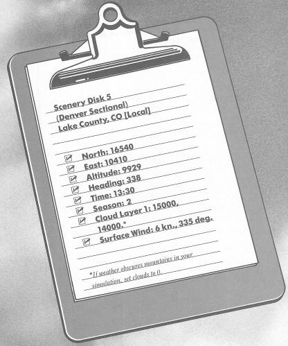
If you look at Lake County Airport on your Denver Sectional (it's airport #7), you probably won't look twice. There is absolutely nothing there to pique the curiosity—no highway, no lake or reservoir, not even a river; just a thin red line. Apparently there isn't even a town out there—just a county named Lake.
But then when you exit the Editor—lo!—a couple of beautiful mountains. And who'd ever know?
Now look out of your windows in all directions. As I certainly don't have to tell you, you're literally surrounded by mountains.
Now engage radar, and zoom out to a high altitude. Keep on zooming, until one notch before the wipeout.
A baker's dozen of mountains! This sectional is a dream come true for mountain pilots.
The highway up there is Interstate 70, which about cuts the state of Colorado in half.
Zoom back down until you can just see the runway, then return to your out-the-windshield display.
This morning we're not going anywhere in particular; we're going to do some mountaineering. And forget any idea of flying over these things. You're already at nearly 10,000 feet and haven't left the ground. Instead of over, we'll fly in and around these peaks a bit, on a tour of discovery.
Before you take off, reflect that at these altitudes you'll need extra power and extra up elevator trim too. In fact, forget flaps altogether for this takeoff—they'll just provide drag to a point where you're unlikely to build up enough speed to get off the runway (try it if you like). You will, however, need your regular takeoff trim; with neutral elevator, the airplane just won't fly. You need considerable speed to get any lift at all in this thin air.
Take her off now. (You can probably read the front page of the New York Times before the VSI budges.) Hold your takeoff trim (if you remove it, you're likely to touch down again) and the notch of rotation, too, and full power, and climb as best you can toward 11,000 feet. Meanwhile, point to fly up the valley that is to your right and ahead of you.
To level off, first back off your power a notch. This will give your overworked engine a break. From there on, adjust trim and/or power as necessary to hold your altitude at around 11,000 feet.
All the mountains in this area (they're part of the Rocky Mountains) are famous for skiing, with the season stretching from Thanksgiving through Easter. That includes Copper Mountain, to your right, and Vail, on your left.
After you cross the Interstate (check out the right side window to be sure you're beyond it), turn right (use some back pressure, or you'll lose a couple of hundred feet of altitude just turning), and follow the highway past the northern tip of Copper Mountain and along the northwestern edge of Tenderfoot Mountain, which is the one you see after you make your turn. Your heading will be in the mid-forties somewhere. Use radar to follow your progress, and take right side views of the valleys.
Don't stray too close to Tenderfoot. These mountains, as you've seen, can be deceiving.
When radar shows that you have definitely passed the northern arrowhead of Tenderfoot Mountain, turn right again, into the valley between Tenderfoot and Grays Peak. (The latter reaches a cool 14,270 feet into the overcast.) The city that drifts across your windshield as you turn is Denver. Tune to Denver VOR on 117.0 to see how far west of the city you are now.
Once you execute your turn, you'll see that Tenderfoot Mountain, on your right, is pretty monolithic. And radar will show you that your right-of-way is pretty narrow. Use your best judgment to determine how to fly through the gap. You'll recross Interstate 70 en route.
You're pretty high up here, for sure, but just a few miles ahead of you, a bit left of your course, is the highest road in the United States, on Mt. Evans. There are cars cruising along that road whose passengers can see you below them.
When you've passed Tenderfoot Mountain, turn right to a heading of about 185 to 190 degrees, or whatever points you toward the valley, this side of the last mountain you can see in the distance.
Take a look out the left side window somewhere along here, and you'll spot Eleven Mile Canyon Reservoir. Just the other side of it are the Florissant Fossil Beds—petrified stumps of sequoia trees, fossil insects, seeds, and leaf structures, all about 35 million years old. If you're a perfectionist, the beds are from the Oligocene epoch of the Tertiary period. That is old. Sequoias are mammoth evergreen trees, which live to great ages and grow to over 300 feet tall. Today they are found only in California and southern Oregon. But in geological antiquity obviously they were here in Colorado, too, which maybe offers us some kind of clue as to the distortions of continental shifting, California being well over a thousand miles away.
Don't take the broad first valley you come to; we want the farther one. Keep correcting gradually to your right to head for it; but treat the mountains with the respect due them. The mountain ahead, by the way, is Mt. Lincoln, and as you get closer you'll see that it develops a distinct, quite sharp pate.
When you're in the clear (check radar regularly), round the point and get on a heading of about 300 to 310 degrees, so you're flying along the western edge of the mountain shaped (on radar) like a diamond. You're going to make another right turn at the next edge, and fly up that narrow slot. Keep a check both on radar and out the right front cockpit window, so you'll know when and where to turn.
Point right up the center of the valley. Check radar frequently, but I recommend you take no side views at the present time.
Imagine, if you like, that there's a bit of rain snapping against your windshield. (That's what it does at this speed—snaps.) I think I just saw a few drops.
Use the lower-altitude radar settings to assess your proximity to the mountains in a case like this. Higher altitudes may lead you to think that you're closer than you really are.
Now look what we've come to!—our old acquaintance, Lake County Airport, sitting there just as nice as pie, and the business end of Runway 34 welcoming us. All you have to do is get into slowflight, start losing some altitude (elevation of the strip, remember, is 9,929 feet), fly a little way into the valley, and make a gentle turn to final. Hold your initial descent rate at around 500 FPM, and make your usual full-flaps landing.
Now if anyone asks you if you've ever done any mountain flying, you can look nonchalant (even slightly miffed) while you tell them of course you have.
Table of Contents | Previous Chapter | Next Chapter