Runway USA
A pilot's guide to destination cities in Flight Simulator
by Charles Gulick
Opportunity Knocks
You've taxied to the end of Runway 8, ready to turn 180 degrees and take off.
But where is that we're supposed to be going? Lake Powell “Opportunity?”
Okay, so I know there's no Opportunity Airport, and not even a so-called Lake Powell Airport, nor any such-named airport, in Utah.
But there is a Lake Powell in southern Utah. It's at the bottom left of your Denver sectional chart—that strange stretch of water that looks like a witch's bony finger pointing heavenward. We flew over its southern extremities in a flight from Bryce Canyon, Utah, to Page, Arizona, in Flight Simulator Co-Pilot. Actually, the lake is a stretch of the Colorado River, and Glen Canyon is the name of the canyon surrounding it.
Now, would I pass up a body of water like that, just because it's at the edge of the chart, and there's nothing but white space for miles around? No way.
So where's Opportunity?
I'll tell you when we get up in the air, and on our course.
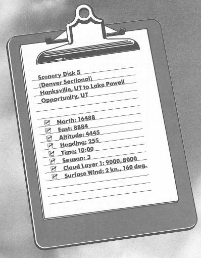
Before you take off, crank in Hanksville VOR on 115.9. We'll use its DME as a distance reference.
Climb out to 5000 feet, and then turn right to a heading of 145 degrees. Continue climbing up to a cruise altitude of 7000 feet.
About six nautical miles from Hanksville you'll see a rim of blue ahead. That's the northern end of the water we're going to sightsee.
So where's Opportunity?
Well, my idea is this:
We'll fly down a good stretch of Lake Powell, taking in the scenery. And as we get toward the southern end, we'll look for an Opportunity to set the airplane down, right along the water somewhere, and have a picnic lunch. Which is why I told you to bring a picnic lunch. (I hope you remembered the hard-boiled eggs, because without them there's no picnic.)
You see, I remember a flight we took earlier in this book, from Laredo to Brownsville, Texas, part of it over Falcon Lake, and I said that one section of the lake bank looked so inviting, I was going to come back and land there sometime. But I never did. So I'm going to make up for it now. Once we've flown most of Lake Powell, we'll look for an inviting spot and set the airplane down.
Let me assure you that I didn't prefly this. I'm heading into this experience for the first time, the same as you. I don't know what we'll find or where we'll land. But the nice part is that in a light plane we can land on any reasonable stretch of grass—that's one advantage we have over jets and other big aircraft.
There are no towns between here and where we're going. Nothing but a little unsimulated road, Utah 95. On your left, paralleling your course but also unsimulated, is Dirty Devil River.
Soon the water opens up in an eye-catching wedge shape. When you're over it, turn downstream. And just look at those lacy islets of green and blue, as far as the eye can see. I thought this would be outstanding, and it is.
Imagine, off to your right, mountains all along this section of the water—all higher than your altitude—because in reality they are there, though unsimulated.
Think what this stretch of the earth would look like if the water weren't there. You'd have a twisting, turning series of promontories and canyons. It might be one of the wonders of the world.
Use radar checks to maintain a generally down-the-middle course. Better yet, fly it as you feel it, enjoying the limitless vistas.
Well, I didn't expect that to happen here, about 52 miles out of Hanksville. If it hasn't happened to you yet, wait until it does, and then read on.
Keep flying.
According to the sectional, we were scarcely two-thirds of the way down Lake Powell when pandemonium hit. Now where do you suppose we are?
There's still water ahead, but neither it nor the skimpy little sluiceways to the left and behind us look anything like the magnificent water we just lost.
Now pause a minute. I have an idea.
Pull Scenery Disk 5 out of your drive and replace it with Scenery Disk 3. Then unpause and hit CTRL-E, following the screen directions.
Now try tuning Page VOR on 117.6.
Aha! Now it comes alive, with the DME reading 30-some miles out.
So that must still be Lake Powell ahead.
Go into radar and zoom around, and eventually you'll get the whole lake on the display again, although we've been shooed way west and somewhat north of our original position. Turn left and get over the lake proper again. We'll do this thing yet.
As you head back toward Lake Powell, look on radar, and find the slimmest piece of land that juts out into the water. On this side of the lake are two bodies of water that look like fishtails. If you sight along the right shoreline of the rightmost of these fishtails you'll see the narrow strip of land I mean. That's where we'll set down.
If you're flying to the left of this landing spot, you'll probably be able to spot it out the right side of your windshield. In any event, fly toward it and over it, and take a good look at it. Look down and watch it go by, too, so you'll have an idea of its width. The length will surely be no problem for us.
Let's make the approach over the water, toward the narrow end. That way we can best gauge where to set the plane down. From the other direction, we'd be approaching the ever-narrower end, making it more difficult to see at what point it gets too narrow.
There's no hurry. Assess your position and the situation thoroughly.
I don't know the elevation there, but I'd assume—from the elevation of Hanksville (4444 feet) and Page (4310 feet) and from the fact that the land appears to be at or near water level—we're dealing with something in the vicinity of 4000 to 4500 feet.
Nonetheless, the situation calls for a long, flat, airliner-type final approach, at about your slowflight airspeed, and at a gently downward-sloping angle, say with a VSI indication of about 200 FPM. So first get into slowflight, then fly to position yourself well out over the lake, or approximately over the shoreline opposite the landing site. What I'm doing is flying more or less a downwind leg to the right of the site, looking it over out the left side, as I would a runway.
But I want to see the whole strip and my touchdown point, behind me, before I turn “base.” I'm planning on an altitude of about 5000 feet when I get the strip of land out in front of me, and from there, it's anybody's guess.
Whatever else, I'm challenging you to land on the little peninsula, coming to a stop somewhere this side of the main shoreline. That should be easy.
I'm flying Cessna at the moment.
I made a wide-sweeping 180 and am correcting back toward the optimum approach position. My altitude is 5400 feet. My VSI reads about 700 FPM down (I had to lose altitude quite fast), and I'm easing that up with back pressure. I have 10 degrees of flaps at present, and my RPM is 1505. My airspeed is at 80 knots, and my carburetor heat is turned on.
At 5000 feet my rate of descent is 400 FPM, and I'm lined up with the point. It's closer than I thought it would be, so I've put on all my flaps to descend more steeply and at lower stalling speed.
My altitude now is 4600 feet, and I am safely over the point, but I don't have any idea what the ground elevation is. My airspeed is 50 knots indicated—lower than I'd like. The little strip looks like a giant runway now, so I increase my power setting to get out of stall range and flatten my glide angle a bit.
Now my altitude is 4500 feet, and my rate of descent is a little above 200 FPM—more like it. Touchdown must be any second now.
There it is. Cut power. Brakes on gently.
My altimeter reads about 4250 feet (not a bad estimate back there, was it?). I take a look on radar, and I'm at the very tip of the peninsula, which is much longer than it looked from the air.
Now I look at the lake out all sides, very self-satisfied and wondering how you did.
I grant you that it wasn't any picnic getting here, but now that we're here, I'm hungry. Get out those hard-boiled eggs, and let's have a picnic—my style.
Table of Contents | Previous Chapter | Next Chapter