Runway USA
A pilot's guide to destination cities in Flight Simulator
by Charles Gulick
The Big Muddy
Pierre is the capital of South Dakota. No doubt you knew that already if you're good at trivia. But unless you're from these parts I'll bet you don't know how the name is pronounced. It's pronounced “peer” —rhymes with “here.” And here I've been saying the name all these years as if it were French.
Pierre Municipal isn't a very big airport, particularly for a state capital; but then Pierre isn't a very big city as state capitals go. Rapid City, far to the west near the Wyoming border, and Sioux Falls, at the opposite end of the state, are larger and more exciting cities. Rapid City is near famous attractions like Mt. Rushmore and the Petrified Forest, and has Dinosaur Park, with its concrete behemoths of antiquity. And Sioux Falls, the largest city in the state, has the Great Plains Zoo and the Battleship South Dakota Memorial, the latter with dimensions exactly those of the battleship itself.
But Pierre has something high, wide, and handsome that those cities haven't—the Missouri River—which is what we're off to see this morning.
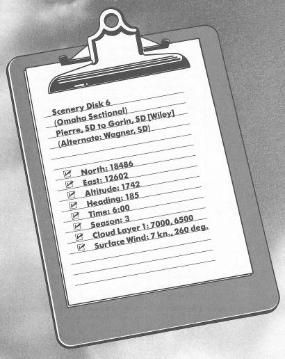
Taxi ahead into position on Runway 25, and proceed with your takeoff. When the runway disappears under your nose, turn left to a heading of 185 degrees.
Level off at 3000 feet. By then you should be over the Missouri River, so turn east and fly between its banks, on a course somewhere around 100 degrees.
Isn't this a beautiful sight? After a couple of miles, take a look behind you, too.
The 2565-mile-long Missouri is the longest river in the United States and the third longest in the world. Only Africa's Nile and the Amazon in South America are longer. It rises where three relatively tiny rivers—the Jefferson, Madison, and Gallatin—all come together in southern Montana. It then winds eastward into North Dakota, turns south through the middle of South Dakota, creates a natural border between Nebraska and Iowa, bends east across Missouri at the two Kansas Cities, and finally joins the Mississippi just above St. Louis. It's called the “Big Muddy,” not because it looks muddy, but because it constantly erodes farmland along its banks. It's a flood threat, too, particularly in springtime.
The geography off to your right, before the first distinct bend in the river, is the Farm Island Recreation Area, and south of that is the Fort Pierre National Grassland. The highway is Interstate 90.
Ahead of you is the Lower Brule Indian Reservation, all along the southern bank of the river, and on the northern bank is the Crow Creek Reservation.
Follow the zigzag course of the Missouri River, trying to judge your turns so you stay over its center. This kind of practice will help you in all your flying, particularly in judging pattern turns, which are far from easy in the simulator. In particular, the turn from base leg to final requires considerable precision, and some of the turns over this river are just as demanding (though far more forgiving). As an alternative to staying over the middle of the river, you can try following one bank or the other, keeping the shoreline ahead of the nose. This is more of a challenge, of course, because who knows where the “middle” of the river is, exactly? Because the aircraft's nose obscures your forward view, your typical error will be to turn too early, thinking you're farther along than you actually are, or then to overcompensate for this experience by turning too late. Use side views, straight-down views, radar views, or whatever helps. Depending on your degree of bank, you can allow two to six full seconds from the time your estimated turnpoint disappears under the nose before you actually start the turn. Try clocking or counting off four seconds and see how you come out, then adjust accordingly.
There's one absolutely wild bend which makes almost a full circle. Don't miss looking at it on radar. In fact, just beyond it is a dam, aptly named Big Bend. Just below the dam are numerous old forts and fort sites, including Old Fort Thompson, Fort Hale, and, considerably further downriver, Fort Kiowa.
With all these turns, don't let your altitude get away. Use back pressure to hold it while you're in a bank, and if you forget to do that, use power to get back up to 3000 feet. You should always fly within 100 feet of your selected (or assigned) altitude.
Eventually you'll cross paths with Interstate 90, where the city of Chamberlain is on your left and the town of Oacoma on your right. Tune Winner OMNI on 112.8 and get on the 216-degree radial inbound (you're very close to that spoke). Or, if you really love rivers and have plenty of time, consult your chart and fly on to Wagner Airport—the Missouri River will point you almost directly to it.
As you fly toward Wiley, don't miss left-side views of the Missouri River, which continues its long journey southeastward to Yankton and Vermillion in South Dakota, and then to Sioux City and Omaha, on opposite sides of the Iowa-Nebraska border.
You'll see from your chart that Wiley Airport in Gorin is 10 or 12 miles beyond the Winner VOR station, but almost exactly on your course, so you should have no trouble spotting it. Since the wind is from the west quadrant, your landing will be on Runway 31. Once you see the field, get over to your left and on a base heading of 220 degrees for a right-hand pattern and with the runway in optimum position for your landing. Or, if you see traffic in the pattern, make the standard 45-degree entry to the downwind leg.
Table of Contents | Previous Chapter | Next Chapter