Runway USA
A pilot's guide to destination cities in Flight Simulator
by Charles Gulick
Husking Corn
Turn on your lights and get rolling immediately, because I want you to enjoy this dawn from the air, and we have only a half hour until daylight.
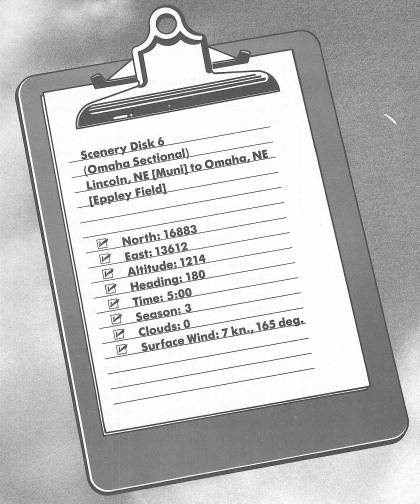
You're positioned for Runway 17L. Make your normal takeoff and climb straight out to 2000 feet on the runway heading. Enjoy some left-side views of the city of Lincoln as you climb.
The highway you'll cross just off the end of the runway is Interstate 80, which more or less parallels the famous Oregon Trail all the way across Nebraska. We'll be seeing more of it.
Continue climbing, and as you pass through an altitude of 2000 feet, tune Omaha VOR on 116.3. Center the OBI needle and turn left to fly the indicated radial. The likely number is 56.
Level off at 3000 feet.
It's too bad you can't see the State Capitol Building in Lincoln, because architects rate it the fourth architectural wonder of the modern world. It's a skyscraper, with a 400-foot-high white stone tower topped by a 32-foot-tall bronze statue called The Sower. On the capitol grounds is a statue of Abraham Lincoln by Daniel Chester French, the same sculptor who designed the famous statue of the seated Lincoln in Washington's Lincoln Memorial.
The city of Lincoln was founded in 1859 as Lancaster, and was renamed in 1867 when it became the state capital. This followed a political battle between “North Platters” and “South Platters,” who wanted a capital, respectively, north of the Platte River and south of it. The “South Platters” won.
You're headed eastward now along Interstate 80. You can see the Platte River, which is about halfway between here and Omaha, cutting across the highway ahead.
Don't let the wind, from your left, carry you off course. Correct as necessary to keep the needle centered.
When your DME reads 30, tune your NAV to Neola VOR, frequency 117.1, center the OBI needle, and take up the new indicated course. We could have flown all the way using the Neola OMNI, but the route we're using will take you more or less directly over the city of Omaha.
Omaha is Nebraska's largest city and a classic example of what the Gold Rush and the railroads—in this case the Union Pacific Railroad, which started the nation's first transcontinental railroad in Omaha—contributed to westward expansion. Today it is a great livestock, meatpacking, and grain-market center. You can enjoy livestock shows and rodeos at the Ak-Sar-Ben Coliseum. (See if you can figure out how that unusual name came about—all the clues you need are in the name itself.) And we're indebted to the Omaha Playhouse for at least two fine actors who got their starts there—Dorothy McGuire and Henry Fonda.
By the way, almost directly ahead of you, to the left of Interstate 80 and before you reach Omaha, is Boys Town, the famous nonprofit community of orphaned and abandoned boys founded in 1917 by Father Edward J. Flanagan. It's governed by its residents, who number about 1000, and survives entirely by virtue of contributions.
We'll be landing on Runway 17 at Eppley Field, which is at the northeast corner of the city. Field elevation is 984 feet. The airport is about 14 miles this side of the Neola VOR, so you'd best get into slowflight before you're over the southern outskirts of the city. Lose altitude very gradually, for a reading of about 250 FPM on your VSI, until you have the airport clearly in view. You'll fly a right-hand pattern for Runway 17, so your present heading is ideal for an entry to the downwind leg. Calculate what the headings for downwind and base will be before you get there. If, as is likely, you're on the 36-degree radial to Neola, you're perfectly positioned for entry. Pattern altitude is 1900 feet.
If you're lucky, day will break before you're on the ground, and you'll see some of the green of the Cornhusker State, and ultimately, right in the center of your windshield, all of the white centerline set off by the black of Runway 17.
Table of Contents | Previous Chapter | Next Chapter