Runway USA
A pilot's guide to destination cities in Flight Simulator
by Charles Gulick
Truman Country
The name “Missouri” is derived from an Indian word meaning “those who have canoes,” and this morning we'll see one area where a canoe makes a lot of sense.
First, however, as we head north, we will be encountering a little weather. You'll have a chance to brush up on your instrument procedure.
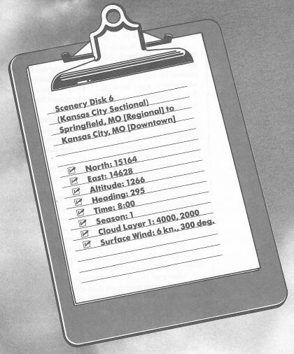
We'll fly to Kansas City via three VOR stations—Springfield, Whiteman, and, finally, Kansas City. Tune in Springfield now, on a frequency of 116.9, and use the OBS to crank in the 348-degree radial with a TO indication (the OBI will still be onscale, but at the right edge of the instrument). The 348-degree radial should point us toward the Whiteman station, which is out of range at the moment.
Take off, and as soon as your altimeter reads about 1900 feet, turn right to a heading of 55 degrees to intercept the Springfield 348-degree spoke. This close to the station, the radials will go by in a hurry, so try to anticipate a bit as your OBI moves toward the center.
At 2000 feet, of course, you'll be into the overcast and on instruments. Climb to a cruise altitude of 4500 feet, which will put you on top of the clouds.
Your OMNI will switch from TO to FROM after a bit of gyration (you're passing the station, which is over to your right). Let it settle down before you attempt to center the needle precisely. By the time you break out of the overcast, chances are things will be pretty much routine.
You can probably raise the Whiteman VOR now, on 109.0, and you'll no doubt find that you're on or within a couple of radials of 348. Fly 348.
When your DME reads 36 NM from the Whitehead VOR, reduce your power to let down through the overcast, at a rate of about 500 FPM. There's something I want you to see, and the terrain altitude is low enough to keep you safe at or a little below 2000 feet. Come back to the text when you're there.
How's that for a scene? Isn't that something?
Level off at 1900 feet and take views to all sides. You're approximately over Harry S. Truman Reservoir, and spread out below you is the giant Lake of the Ozarks. At the eastern edge of the lake is Lake of the Ozarks State Park. If you look on radar, you'll see that this body of water resembles a long-nosed man running with a pitchfork. Trailing behind him is the Osage River, which joins the Missouri River to the northeast.
This lake has an irregular, wooded shoreline nearly 1400 miles long, so you see what I meant when I said that a canoe would be useful. In fact, any type of boat would be handy. Lake of the Ozarks has about 14,000 registered boaters, and the State Park is equipped with boat-launching ramps as well as many fine beaches and campgrounds. The park is a major vacation area, covering some 16,500 acres.
You'll fly almost directly over Harry S. Truman State Park, which is up near the runner's head, on the northern banks of the reservoir.
The highway you see intermittently ahead of you is U.S. 50. Whiteman Air Force Base, where the Whiteman VOR is located, is just this side of the highway.
Maintain your cruise altitude of 1900 feet (any higher and you'll be in the weather again). When you're about five miles out from Whiteman, change your NAV frequency to 112.6 and get on a radial inbound for Kansas City. I'll be on radial 308, so join me if you like. U.S. 50 will be off to your right, and beyond that, east/west Interstate 70 is barely discernible out the window, but is clearly defined on radar.
The Kansas City we're flying to, in case you're confused (you're not the first to wonder which Kansas City is which), is the one in Missouri, not the one in Kansas. The Missouri River divides the two, although together they're regarded as the Greater Kansas City Metropolitan Area.
Go into radar and observe the three major highways that point the way. They are, from left to right, U.S. 71, U.S. 50, and Interstate 70. You're probably closest to U.S. 50, which is where you want to be. In fact, you can abandon the Kansas City VOR at this point and follow the highway. It will point you directly to Kansas City Downtown Airport, which is in the north central section of the area. Don't parallel U.S. 50 precisely, but use radar and point toward where the highway enters the metropolitan area; otherwise, you'll fly a meandering course and waste time.
The near section of the metropolitan area represents Independence as well as Kansas City, Missouri. You'll pass a bit to the left of Independence and approximately over Raytown, Missouri. Independence is justly famous as the home of Harry and Bess Truman, and the site of the Truman Library-Museum. The former president is buried there. On the southwestern edge of Independence is the Harry S. Truman Sports Complex, just this side of Interstate 70.
Kansas City Downtown Airport is the first airport you'll see as you approach the city. The airport sits at a bend on the north shore of the Missouri River, at its junction with the Kansas River. The airport field elevation is 751 feet. Our landing will be on Runway 36 (or 0, if you like). If you get on a heading of 270 degrees, with the airport well to the right on your windshield, you'll be on a right base leg, which is fine for this strip. Give me a nice approach and I'll buy you a drink at Kelly's Westport Inn, the oldest building in town.
Table of Contents | Previous Chapter | Next Chapter