Runway USA
A pilot's guide to destination cities in Flight Simulator
by Charles Gulick
High Drama
NOTE: The mountains described in this and the following chapter are not, unfortunately, in the Scenery Disks for all computers. If you see no mountains, you'll just have to make the flights as described and try to imagine them.
Talk about beautiful! This has to be (if you have mountains) one of the most inviting runway scenes in the simulator world. Spend a minute just looking at it. You and I may be the only ones who ever see it just this way.
Those are the Sangre de Cristo Mountains, with peaks such as Thompson (10,546 feet) and Baldy (12,623 feet). You'll see them up closer, because Santa Fe is on the other side of them. The whole area between here and there is Santa Fe National Forest.
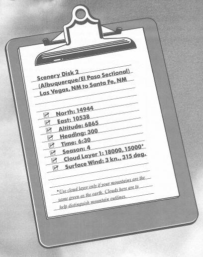
This is Runway 32 at Las Vegas, New Mexico—a Las Vegas for those who choose mountains, streams, and wilderness over slot machines, smoke, and gambling tables.
Let's go flying!
Tune your NAV to Santa Fe, 110.6, and crank in a course on your OBS—my readout is 252 degrees.
We're already at high altitude, nearly 7000 feet, so your takeoff run will be long. Rotate as usual, but after rotating, don't trim elevator at all. Dump your flaps when you're climbing better than 500 FPM, but still don't trim at all, and stay at full power until I tell you otherwise. We have a big mountain to clear.
When you've climbed to 7500 feet, make a standard-rate left turn to the heading on your OBS. You'll find that the OBI needle has moved a few degrees to the left, but in this case, reset the OBS to center the needle and then fly it, rather than correcting to get on the original radial. The radial I'm flying now, as a result of the foregoing adjustment, is 248 degrees.
Remember, don't change your power setting. Keep climbing, and now use gradual up-elevator trim as needed to keep your rate as close to 1000 FPM as you can. You'll find you're trimming constantly, which is what you should be doing. But notice how your airspeed drops very slowly.
Soon you'll see some signs of civilization over on the other side of the mountain. The highway that you see is Interstate 25.
At some point, you're likely to get a stall warning. Respond with one stroke (or two if necessary) of down elevator, and let the climb rate slowly settle lower. By now you should have sufficient altitude to clear the mountain.
When you're over the top, slowly adjust trim and reduce your power for straight-and-level flight. To achieve this, primarily use trim, together with a power reduction of perhaps 100 RPM. Your elevator-position indicator should be at the three-quarter mark by the time you're level.
Ahead are the foothills of another mountain range and another beautiful scene, composed of Interstate 25, the Santa Fe National Forest, and the Rio Grande River. The river and the highway are headed for Albuquerque, but we're traveling to Santa Fe.
If you've let the OBI needle stray, don't worry; it hasn't moved very far. If you keep a lookout to the right, using a 45-degree view, you'll soon see the city of Santa Fe, north of the highway. Santa Fe County Airport, however, is south and west of the city.
You climbed to a pretty high altitude, didn't you? And now you have to shed all those thousands of feet. Here's an exciting, but completely safe, way to do it:
(Just before you do this, you may want to go briefly into the Editor, save the mode exactly as it is, and exit again. Then, if you misjudge your approach, you can return to this moment of the flight and try the procedure again.)
Leave your elevator where it is.
Notch by notch, take off all your power. The aircraft will, of course, pitch down.
Again notch by notch, extend your flaps fully.
You'll start a descent at better than 1500 FPM. Take a look out the side of the aircraft, to get an idea of your attitude in relation to the horizon.
Note your airspeed, and realize that you are not diving out of control toward the ground. If you were, your airspeed would be redlining, but we're approaching this maneuver very conservatively.
Observe your altimeter carefully. When it reads 8000 feet (remember that you're above 10,000 feet as long as the thousands indicator is on 1; you'll be at 8000 when the short hand is on 8 and the long hand on 0), take up your flaps, a notch at a time, then gradually add power to achieve your normal slowflight airspeed (which is approximately 70 KIAS in Cessna, and 84 KIAS in Piper).
Try to achieve a straight-and-level slowflight condition by the time your altimeter reads 7500 feet. Your throttle (RPM) setting to achieve slowflight at this altitude will be higher than at, say, 2000 feet.
Now, wasn't that delightful? From the ground, it might look as if you were doing something dangerous; but you were in precise control all the way. (At least I hope so; and if you weren't, press Recall and try it again.)
This hurry-up descent demonstrates one of the great things about flaps: They let you descend more steeply without excess increase in airspeed. In fact, although you seemed to be “diving,” your airspeed throughout was in the slowflight range. Isn't that a neat maneuver?
But now we have a landing to make.
Continue on your present heading until, out the right front window, you see Santa Fe County Airport—just across the highway. A heading of 240 degrees will put you on a course paralleling the right base leg for Runway 33. The field elevation is 6344 feet. Take over visually and when you're ready, turn right for a long final approach.
In Cessna, if your altimeter is like mine, it may read deceptively at this altitude. In my version, the thousands hand is definitely below the 6 on the ground at Santa Fe, so the altitude looks like five thousand something, even though the hundreds hand indicates correctly at about 344 feet. A check of the Editor, however, will show the actual elevation to be 6344 feet at this airport.
Table of Contents | Previous Chapter | Next Chapter