Runway USA
A pilot's guide to destination cities in Flight Simulator
by Charles Gulick
The Devil You Say
Here's where we'd be if it weren't for the malevolence of those mountains. After crossing the last two ridges we'd have seen this pretty little Tracy Municipal Airport lying here. Well, the scene may have been ruined, but the play isn't over yet.
Take a right rear view. You see the same two mountains we made a heroic effort to cross, and on the other side of them are still two more, which we did cross. On the other side of all four mountains is San Jose Municipal Airport.
Now, here's a curious thing. Take a radar view, and zoom to high altitude. Keep zooming and you'll see all four mountains behind you and to the right. Two that shall be nameless, then Eylar Mountain, and then Mt. Hamilton. The curious thing is that radar views from San Jose—no matter how high one zooms—show only Eylar Mountain and Mt. Hamilton. Yet from Tracy we can see all four mountains.
This leads me to a prediction, and a proposition. The prediction is that because all four of the mountains are acknowledged by radar, we can fly over them without incident and will be able to view them all—ahead of us, and then behind us—before we get to San Jose. Since they're already part of the stage set, there should be no sudden curtain fall as in our last flight. In short, I predict that there is a way over the mountains, but only one way—this way.
The proposition is that we follow our original flight plan, but in reverse—from here at Tracy Airport to our destination at San Jose International Airport. I think you'll agree that it's worth finding out whether it can be done. The prospect of seeing more mountain scenes such as we saw on the earlier flight, though only briefly, is itself exciting. What's more, we'll discover something—though I'm not sure what—about the way the simulator behaves.
I anticipate disk accesses along the way, and possibly a sudden mountain appearance or disappearance, although I think that less likely. What I do not anticipate, based on the radar clue mentioned above, is—you know—curtains.
This could be one of our most scenic flights, or one of our most catastrophic. But surely, it will be one of our most suspenseful.
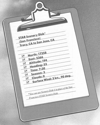
If our heading to get here from San Jose last evening was 30 degrees, then we'll fly the reciprocal, 210 degrees, to go the other way this morning.
The same rules apply. We'll take off, climb to 1000 feet before turning to our 120-degree heading, and then keep climbing, 500 FPM all the way, unless something dictates that we do otherwise.
If you're ready, let's go.
When you have reached 1000 feet, make a right turn toward your course, with a bank of about 25 degrees. That's the shorter way around, considering the runway heading is 70 degrees.
Looks like we're headed close to the peak of Nameless One, doesn't it? But we should have the altitude we need when we get there.
Not a great deal to spare, though. Wow!
Beautiful valley when you see it, hmm? Keep climbing. Hopefully we're going to top the next ridge in the same way.
Did you know that this whole string of mountains is part of the Diablo Range?
I wonder why.
Table of Contents | Previous Chapter | Next Chapter