Runway USA
A pilot's guide to destination cities in Flight Simulator
by Charles Gulick
East Side Story
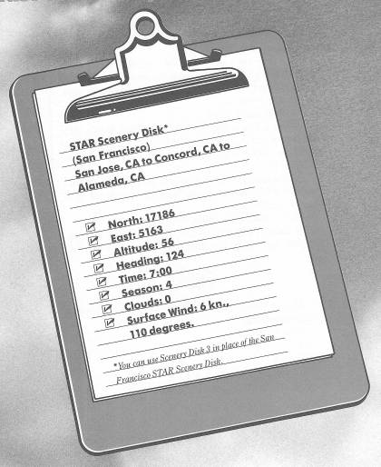
On this perfect fall morning we're going to fly north to Buchanan Field, in Concord, California. We'll take off from Runway 13L, which is about 45 degrees to your left across Runway 13R, and then you'll have tried all the runways here at San Jose. Line up right behind the numbers, so that they're visible over your nose, and then hold for a minute.
Since you may opt to adopt San Jose as your home airport in the San Francisco Bay area, I want to tell you a couple of other things about this city.
Zoom up to the highest radar view that still provides some representation of San Jose's runways. You'll see just a piece of Mt. Hamilton over to the left, a cluster of buildings straight ahead, and the network of highways leading into and out of the city.
The highway right off your nose, you'll remember, is Highway 17, or the Nimitz Freeway. It's intersected just to your left by U.S. 101. If U.S. 101 were continuous in the display, it would draw a diagonal straight through your position. The highway to the far left is Interstate 680, or the Sinclair Freeway, which turns sharply right and links with Interstate 280 to skirt the San Jose business district. It then connects with Highway 17 at about 2 o'clock in relation to your position.
Just this side of that Interstate 280/Highway 17 intersection is a house called the Winchester Mystery House.
Do you remember reading or seeing a TV feature about a wealthy Mrs. Winchester who was told by a medium that she'd never die as long as she kept adding to her mansion? So for 38 years she had carpenters build rooms upon rooms and stairways leading nowhere, and then, as you might expect, she died anyway. The carpenters no doubt got rich; and one wonders about the medium who gave Mrs. Winchester the sage advice. The house is a tourist attraction in San Jose, on Winchester Road.
Another feature of San Jose is the Rosicrucian Egyptian Museum located in Rosicrucian Park, to your right across Highway 17.
There are also numerous wineries in the area that offer free tastings (to those who are not going flying, of course).
Tune your NAV to Concord VOR, 117.0, and center your OBI needle for a heading that we'll fly to Buchanan Field. Then take off and climb to 1000 feet before you turn left to get on course, continuing your climb to our cruise altitude of 4000 feet.
The airport you'll see along the way, left of Highway 17, is Fremont. Off to your left, though it's not visible in the simulation, is Marriott's Great America Theme Park. The whole area of Santa Clara County, to your left and behind you, and including San Jose, is famed as “Silicon Valley” for its pre-eminence in the high-technology industries. Silicon Valley's brain trust is Stanford University, in Palo Alto. It has one of the highest academic standings in the United States.
Somewhere out the left side you should be able to spot Dumbarton Bridge and its companion, the Hetch Hetchy Aqueduct, and out the right side the Calaveras Reservoir.
Across Highway 17 from Fremont Airport is something reminiscent of the Santa Clara County Fairgrounds, but I'm not sure what it is. You may pass directly over it, in which case take a down view.
If you've been climbing all this while at about 500 FPM, you're probably just reaching your cruise altitude (3500 feet) as you approach the mountain that intersects your course. I don't know about you, but I've come to suspect every mountain in the San Francisco area, almost to the point of paranoia. However, this one looks civilized, by which I mean you can see highways and parts of metropolitan areas on the other side of it. Not to mention still another shape like a county fairground in the distance.
Whew!—we made it over the mountain! When you can no longer see any of it, you can ease back your power and descend to 1000 feet. Buchanan Field's elevation is only 23 feet. The airport is about four nautical miles this side of the Concord OMNI, so you can deduct that many miles from your DME reading in judging your descent.
After the disk access, you'll see the namesake of the Diablo Range, Mt. Diablo itself, out the windshield to your right. The highway going through the Concord metropolitan area (you've paralleled it all the way from San Jose) is Interstate 680.
Contact the Buchanan ATIS on 124.7 and see what runway is in use. If Runway 14 is in use, then we'll use 14R, which is the strip for small private aircraft. Whatever the runway, follow a left-hand traffic pattern.
Referring to your sectional chart, where in general do you expect to see Buchanan Field as you approach the Concord OMNI? You should have it in view when your DME reads 10 NM, which would put you about six miles out.
This is a sizable major airport, so enter the pattern in a regulation manner.
After you land, steer over onto the grass to your right, turn 180 degrees, and taxi back to take off again on Runway 14R. We'll fly right on to Nimitz Field, which is in the shadow of the eastern end of the San Francisco-Oakland Bay Bridge. Don't change anything. Just line up for 14R, make your takeoff check (carb heat off, flaps 10 degrees, elevators trimmed up two notches), and depart.
As you reach 500 feet, turn right and take up a heading of 210 degrees.
Well, looks like we've some more mountains to cross. But actually, they're just hills—called the Briones Hills. Plan to cruise at 2500 feet.
A panoramic landscape unfolds as you approach the hills, and you begin to see the world on the other side. There's another disk access, and then you can see the city of Berkeley ahead, San Francisco's downtown buildings far off to the right, and all the way to the Pacific Ocean.
A right front view shortly will show you the Golden Gate Bridge to Sausalito, with the San Francisco-Oakland Bay Bridge in the foreground. Nimitz Field is on the edge of the bay, but fly on out over the water, transition to slowflight as you go, and prepare to descend to 1000 feet.
Your reveries will likely be disturbed by an ILS marker signal, but ignore it; it isn't for you.
As you near the bay shore on the San Francisco side, turn right to a heading of 40 degrees, or whatever aims you over the approximate center of Nimitz Field. You'll be more or less at right angles to the runway on which you're going to land, Runway 13. When you can see the runway behind you, set up a 90-degree view to your left, and at the same time turn left, heading 310 degrees. You should wind up just about opposite, and downwind from, the business end of Runway 13, so proceed with your landing. Your heading for base leg is, of course, 220 degrees.
After we land, I'll show you around Alameda Naval Air Station. And we'll be back in San Jose in time for lunch.
Table of Contents | Previous Chapter | Next Chapter