40 Great Flight Simulator Adventures
by Charles Gulick
Fasten Seat
Belts
Belts
| North Position: 14758 | Rudder: 32767 |
| East Position: 6106 | Ailerons: 32767 |
| Altitude: 15 | Flaps: 0 |
| Pitch: 0 | Elevators: 32767 |
| Bank: 0 | Time: 13:30 |
| Heading: 9 | Season: 1-Winter |
| Airspeed: 0 | Wind 415 Kts, 300 (415 Kts = 15 Kts + Turbulence Factor 4)* |
| Throttle: 0 | |
| *If
turbulence is
not implemented in your version of the simulator, set wind to 4 Kts and
ignore turbulence commentary. |
|
| Add for this mode: Cloud Layer 2: Tops, 6000; Bottoms, 5000 Cloud Layer 1: Tops, 2000; Bottoms, 1500 Shear Zone Altitude 1: 3000 |
|
| Not the best possible day for
it, but you'll be making a trip up the
southern coast of California, from San Diego's International Airport
(Lindbergh Field) to Fallbrook Community Airpark, about 40 miles north.
Fallbrook is a city (population 9000) just west of Interstate 15. |
|
 |
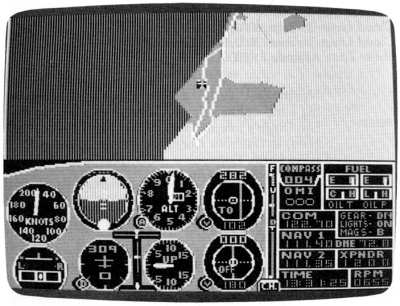
You're on the taxiway for runway
31. Go into radar and zoom until you can see the runway numbers ahead. |
 |
Call the tower on 134.8. They'll
advise you of the ceiling. But not of
the turbulence. You've heard other pilots reporting that. Anyway, it
shouldn't be too bad (the factor is 4 of a possible 9). Tune your NAV to Mission Bay VOR, 117.8,and set your OBI to intersect the 346-degree radial after you fly past the station, which will be a few minutes after you're airborne. |
|
Zoom your radar out to a high
altitude view so that you see Mission Bay
behind your aircraft, together with most of the San Diego metropolitan
area. Though it isn't featured in the simulation, there's a U.S. Naval
Air Station across the bay on a little nub of land called North Island.
And there's a Naval Training Center a few miles to your left. So watch
out for navy jets. The highway right off your nose is Interstate 5, and it's approximately paralleled by Interstate 805. Where they meet on the lower right of your screen is just about Tijuana, Mexico. (International, hmm?) |
 |
Continue taxiing, line up on the
runway, and take off. Plan to cruise
at 4500, between the cloud layers. And get on the 346 radial as soon as
you have a FROM reading on your VOR indicator. Wow! If this turbulence factor is 4, what's a 9? Thought this would be an easy flight, didn't you? Fifty miles of this!? And weather on top of everything else. What in the world is so important that you just have to do at Fallbrook? Will it ease off when we stop climbing? Whatever you do, don't let that turbulence flip you over (it can). Then, ah-h-h. Above 3000. Ah-h-h! Glass. A mere. Serenity. Bliss. So that's what shear altitude does. The wind and turbulence go from the surface to the shear zone altitude. Then both the wind and the turbulence quit. Lovely. |
|
When your OBI indicates FROM,
start flying to intersect the 346 radial.
You were probably buffeted off your takeoff heading, and perhaps you're
a bit disoriented. Remember, you can use the indicator to find out what
radial you are on, if the
needle is off the scale. Then you'll know
which way to turn to intersect the radial you want. And ultimately, fly
the needle (turn toward the needle). When the needle is centered, with
your heading on the course selector, at that moment you're on the
radial, so turn directly to the selected heading. You can, of course,
anticipate it with a little practice. If you find, once you get on the
radial, that the needle keeps moving to the left or right, correct your
heading accordingly until it stays put. Just because your heading is
346 doesn't mean you'll stay on the 346 radial. Your nose could be
pointed 330 or 360 or anywhere in between. You're only on the 346
radial if the OBI needle is centered on that heading. The culprit, of
course, is the wind. |
|
When you're settled down, at
your altitude and on your heading, take a
look at radar. You're pointed a bit inland. The metropolitan area ahead
of you is Oceanside, California. When your DME reads about 19.5 miles, adjust your radar to spot the city of Carlsbad's McClellan-Palomar runway to your left (nice how radar penetrates right through the overcast, isn't it?). |
|
When you're 25 or 30 miles out
from Mission Bay VOR, you might as well
face the fact that you have to let down and make a landing in all that
turbulence. Because, of course, the turbulence didn't go away below
you. Where would it go? Fallbrook's elevation is 708 feet, and the runway you're supposed to land on is 36. As you descend through the overcast, your instruments are all you have. So don't even consider the possibility that they're wrong. At such times, they're right even if they're wrong, because your instincts are worse than the worst instruments. In fact, in this stuff there's no such thing as instinct. Or seat of the pants, either. Just look at that artificial horizon dance! |
|
The ground comes into view at
1500. So try to stay on (or get back to) that heading of 346. Won't you be glad when this turkey's on the ground? Anywhere on the ground! If you happen to see a black (orange on the IBM) mountain, the runway's somewhere this side of it. By the same token, if you happen to see a runway, there's a black mountain somewhere the other side of it. If you land even close to the runway at Fallbrook, you can be very proud of yourself. And it you don't, so what? Who ever heard of a black (or orange) mountain anyway? |
Table of Contents | Previous Section | Next Section